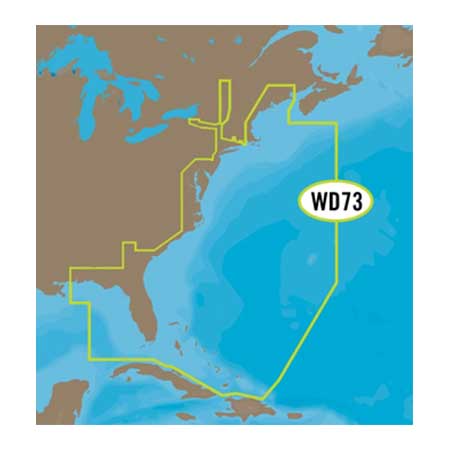
C-MAP 4D Full, US East Coast, Bahamas, SD/MSD
Item: NA-D022-SD
This item is brand new
$275.95
This item ships within 2 days


This item is brand new
$275.95
This item ships within 2 days
Contents of the package
Features
4D NA-D022 USA EAST COAST AND BAHAMASC-Map 4D Chart for U.S. East Coast and Bahamas, on SD/MSD Card
Full Option, with 3D Viewing, Satellite Images, and Digital Raster Charts
C-MAP 4D is the only maritime chartplotting solution that lets you completely customize your digital navigation charts. You choose the content (MAX or 4D), and you choose when to purchase additional Value-Added-Data (Hi-Res Bathymetry) to enhance your boating or sailing experience.
Base Cartogrpahy
Port Info
Tidal Heights
Tidal Flows
Animated Tidal Arrows
Ocean Currents
Guardian Alarm
Detailed Harbor Charts
C-Marina Port Database
California MPA's (US only)
Major Roads
Detailed Roads
Aerial Photos
European POI's
Land Elevations
Nav-Aids
Multi-Language (UNICODE)
Perspective (Bird's Eye) View
3D View
Satellite Images Overlay
Raster Charts Overlay
Easy Routing (on some plotters)
Specifications
Item number: NA-D022-SD
UPC: 686074003361
Package weight: 0.10 lb
List of Compatible Units:
Note: Displayed are products sold in gps4us store.
There might be more GPS units compatible with chosen accessory.