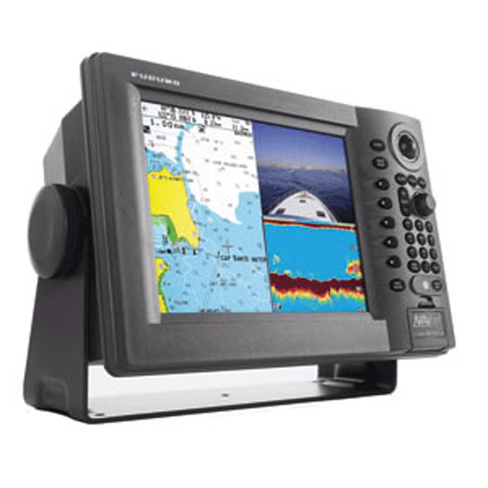
FURUNO NavNet 1834C NT vx2 Radar - C-Map NT
Item: 1834C/NT
This item is brand new
$5,095.95
This item ships within 9 days


This item is brand new
$5,095.95
This item ships within 9 days
Cables


000-159-705
NavNet PC Adapter Cable, 6 pin to RJ45
NavNet PC Adapter Cable, 6 pin to RJ45
No Longer Available

Connectors

Kits

Mounts


Marine Networking


Kjm-c50R
Dome Camera, Surface Mount,Rev. Image
Dome Camera, Surface Mount,Rev. Image
No Longer Available

BBWGPS
NavNet WAAS/GPS Antenna w/ NMEA0183
NavNet WAAS/GPS Antenna w/ NMEA0183
No Longer Available

DFF1
DFF1 Digital(FDF) BLACK BOX Echosounder Module f/NavNet
DFF1 Digital(FDF) BLACK BOX Echosounder Module f/NavNet
No Longer Available


MU-170C
MU170C 17 inch Color Marine LCD Monitor
MU170C 17 inch Color Marine LCD Monitor
No Longer Available
Radars


Sensors and Boards

Compatible maps
Suggested Maps and Software:
 | Navionics Marine Charts |
MAX Charts SD Card |
Contents of the package
Box 1 Dimensions
15"H x 15"W x 19"L WT: 24.4lbs
Box 2 Dimensions
14"H x 27"W x 28"L WT: 25.0lbs
Box 3 Dimensions
5"H x 17"W x 17"L WT: 9.9lbs
15"H x 15"W x 19"L WT: 24.4lbs
Box 2 Dimensions
14"H x 27"W x 28"L WT: 25.0lbs
Box 3 Dimensions
5"H x 17"W x 17"L WT: 9.9lbs
Features
NavNet vx2 combines radar, GPS/WAAS chart plotter, fish finder, and network weather facsimile into an all-round navigation network. Its wide range of options fulfills virtually every desire you may have for navigation system.Radar, GPS, Network fish finder, Network weather facsimile - a multistation integrated navigation network, NavNet vx2 lets you build your navigation system according to your needs. Utilizing state-of-the-art network technology, NavNet vx2 provides you with seamless data sharing and vast future expandability.
The heart of NavNet vx2 is its Ethernet-based network. Up to four displays, together with various navigational sensors, can be interconnected in addition to new MaxSea-NavNet navigational software, which adds even more features to your NavNet vx2 network. Stress-free navigation can be performed from any display unit connected to the onboard network, due to the high-speed transfer of data available.
- All display units are capable of controlling any component connected to the NavNet network
- Perfect for single or multi display installations
- Fully supports C-Map NT MAX charts
- Utilizes SD cards for chart and memory
- Fast chart drawing speed
- Straightforward Plug n Play installation with wizard style set-up
- AR-coated, high-brightness display unit for improved sunlight viewability
- Sunlight Viewable 10.4" Color VGA (640 x 480) TFT LCD Display
- AR-coated, high-brightness display unit for improved sunlight viewability.
- Automatic GST (Gain, Sea Clutter, Tuning) Receiver
- Target or Echo Trails with Selectable Time Intervals
- Commercially popular SD chart/memory card format
- Full compatibility with C-Map NT MAX charts
- Enhanced graphics with 256 color full VGA presentations
- Improved screen redraw, scroll refresh, and memory cache
- New Quick Point L/L direct entry waypoint
- 100 target AIS display with I/F module and external AIS Rx
- Simplified installation with new Network Wizard set-up
- Adjustable (In or Out) Radar Guard Zone Alarm
- Picture Off-Centering or Target Zoom Mode
- Cursor L/L Position Display **
- Watchman Mode activates the Radar for Safety and Security
- On-Screen Display of Vessel Position, Heading, etc. *
- Waypoint Lollipop On-Screen, to simplify Navigation * or **
- Full Functioning Infrared Remote Control
- Radar Overlay available with appropriate heading sensor (i.e. PG500R)
- Vessel Position Display in L/L or Loran-C TD's
- North-Up, Course-Up or Automatic Course-Up display modes
- Plotter, Nav Data, Steering Director or Highway display modes
- Up to 8,000 points for ship's track and marks, 999 waypoints, 35 quick points, 1 MOB, 200
- planned routes (max. 35 waypoints/route) and 1 quick route
- Add Multiple Displays by Connecting to NavNet Interface
- Add Network Sounder by Connecting to NavNet Interface
Power Requirements:
Specifications
ARPA AvailableYes
Array Size (Inches)
24"
Basemap
Yes
Cable Length (Meters)
15m
Card Format
SD
Cartography - Preloaded
No
Cartography Brand
C-Map
Cartography Type
MAX
Hor/Vert Beam Width
3.9 -20
Power - Output (Kilowatts)
4kW
Range - Max (Miles)
36nm
Range Scale
1/8 - 36
Resolution (VxH)
480 x 640
Screen Size
10.4"
Touchscreen
Yes
Product Dimensions
10.4"H x 15.1"W x 7.1"D
Item number: 1834C/NT
UPC: 611679288714
Package weight: 59.3 lb