GARMIN Dezl 760LMT


Video cable for backup camera

Universal 7 inch soft carrying case


Cup Holder Universal Mount RAM-A-CAN II with 6 in Flex Arm


Cradle Adapter with G-Ball

FMI 45 Fleet Management Interface Cable with data and traffic

GTM 36 lifetime traffic

BC 20 Wireless Backup Camera
Suggested Maps and Software:
 | Inland Lakes |
 | Garmin Street Maps and City Navigation |
 | Garmin Topographic Maps |
 | Garmin Extras |
Contents of the package
- dēzl 760
- Preloaded City Navigator® NT for North America (full coverage)
- Lifetime maps and traffic (indicated by "LMT" after model number on the box)
- FM traffic receiver with 12/24 volt power cable
- Vehicle suction cup mount
- micro-USB cable
- Quick start manual
Features
The dēzl 760LMT is the navigator with a big 7 screen designed specifically to make a truckers life easier. Not only can it guide you along a route customized for your truck and trailer, it helps ensure youre in the proper lane with Active Lane Guidance. It also helps with IFTA and HOS logging. It also shows you exit services ahead, along with trucking points of interest (POIs). When you trust dēzl 760LMT to create a route for you, youll know its a good route for both you and your rig.Track and Report Your Trips
The dēzl 760LMT makes logging and retaining trip information easy. You record fuel usage, and the 760LMT automatically records state mileage for IFTA fuel logging. Log your hours of service and driving status, and the 760LMT tracks your hours and automatically warns you of HOS violations. Conveniently export all logs for improved reporting and tracking of each trip.
See More
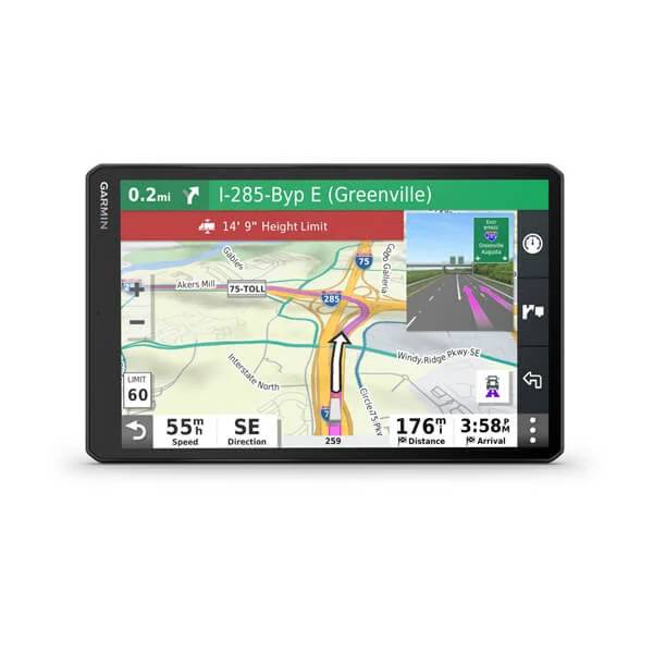
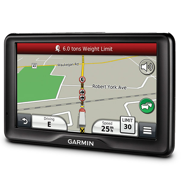
With a large 7" high-resolution touchscreen display, dēzl 760LMT allows you to see tons of information in great detail. Clearly follow the highlighted truck-friendly route, view truck warnings, notifications and alerts. And only a dēzl 760LMT includes exclusive Garmin Active Lane Guidance (ALG). ALG shows you constantly updated animation of the preferred lane to be in. It also includes photoReal junction view, which provides photo-realistic views of upcoming junctions to guide you to the right lane at the right time. All of which are especially helpful when navigating complex highway interchanges in unfamiliar metros.
Navigate with Confidence
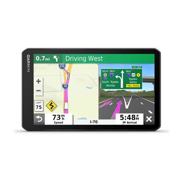
With detailed maps and turn-by-turn directions that speak street names loud and clear through the speaker, dēzl 760LMT provides specialized routing¹ to support truck-related restrictions in both the U.S. and Canada (customizable by height, weight, length, width and hazardous materials). Simply enter dimensions and load restrictions, and dēzl 760LMT guides you according to your requirements on a route that fits your load. The onboard Trip Planner lets you create multiple-stop routes and plan and save future trips. And, you can operate dēzl 760LMT with voice-activated navigation. Its so easy, you just talk to it!
NOTE: Always defer to all posted road signs and road conditions.
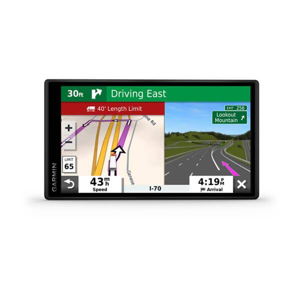
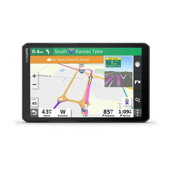
Drive Safedēzl 760LMT keeps you informed of upcoming road conditions, such as sharp curves, bridge heights, weight limits, high wind areas and restrictions, including no trailer or hazardous materials. A grade data field that appears on the map enables drivers to anticipate descents and ascents and shift accordingly. Trucking speed limits appear if they are different than the posted automotive speed limit. It also provides mile marker information. Plus its clock automatically changes time zones and provides sunrise/sunset times. You also receive notifications when crossing state or country borders. For added peace of mind, there also is a video input for backup camera compatibility.
Locate Trucking Service Areas and POIs
dēzl 760LMT has truck-specific POIs to let you search roadway exits for truck stops, food, lodging, rest areas, service locations, tire repair and weigh stations. Truck stop information includes a list of services offered, such as WiFi, showers and truck scales. And enhanced exit services let you know what services are available at upcoming exits along your route.
Includes Lifetime Map Updates
Right out of the box, the dēzl 760LMT comes bundled with nüMaps Lifetime. Which means you can download the newest map data when it becomes available no monthly fees or maintenance costs for the lifetime of your device².
Includes Lifetime Traffic
A combination power cable/traffic receiver in the box gives you traffic services for the life of your device. Youll avoid traffic jams and keep moving when your dēzl 760LMT alerts you and offers detours. No additional purchases are necessary its 100 percent subscription-free traffic³.
Smartphone Link Compatible
Smartphone Link makes your smartphone the best thing next to your dēzl 760LMT. Its an application available from Google Play. Smartphone Link creates a seamless navigation experience between your dēzl 760LMT truck navigator and an Android smartphone. It allows the devices to share information, such as saved and recently found locations, where you parked and your current destination. It also links your compatible dēzl to Garmin Live Services4, such as weather and fuel prices using your smartphones current mobile data plan. Theres no need for an additional data connection5.
For example, a subscription to Garmin Live Services Advanced Weather allows you to receive severe weather alerts and view animated radar images on the dēzl.
Make Hands-free CallsFor hands-free calling, dēzl 760LMT integrates Bluetooth® wireless technology with a built-in microphone and speaker. Just pair it with your compatible Bluetooth phone and talk hands-free through the 760LMT while staying focused on the road. Simply dial numbers with the dēzl touchscreen keypad to make a call. To answer calls, just tap the screen and speak into its built-in microphone. Enjoy convenient one-touch dialing for contacts and POIs.
¹Only available on certain roads in the lower 48 states. Entering your trucks profile characteristics does not guarantee your trucks characteristics will be accounted for in all route suggestions. Always defer to all posted road signs and road conditions.
²If you purchase a nüMaps Lifetime subscription (sold separately or bundled together with certain GPS models), you will receive up to 4 map data updates per year, when and as such updates are made available on Garmins website, for 1 compatible Garmin product until your products useful life expires or Garmin no longer receives map data from its third party supplier, whichever is shorter. A products useful life means the period during which the product (a) has sufficient memory capacity and other required technical capabilities to utilize current map data and (b) is capable of operating as intended without major repairs. A product will be deemed to be out of service and its useful life to be ended if no updates have been downloaded for such product for a period of 24 months or more. Unless otherwise stated, the updates you receive under the subscription will be updates to the same geographic map data originally included with your Garmin product when originally purchased. In some instances, your Garmin product might not have sufficient memory remaining for you to load an update to the map data, in which case you will need to either (a) select reduced map data coverage for your updates, or (b) purchase separately a microSD/SD card (if and as applicable to your Garmin product) and load all or a portion of the map data coverage for your updates to the card and insert the card into the microSD/SD card slot contained in your Garmin product. If neither of the measures in (a) or (b) can be used to address your products lack of sufficient remaining memory, then Garmin may conclude that the useful life of your product has expired. Garmin may terminate your nüMaps Lifetime subscription at any time if you violate any of the terms of this agreement or your subscription. Your nüMaps Lifetime subscription may not be transferred to another Garmin product.
³FREE lifetime traffic updates may not be transferred to another
person or another Garmin product. Lifetime traffic extends for the
useful life of your Garmin traffic receiver (as long as you own a
compatible Garmin GPS) or as long as Garmin receives traffic data from
its traffic supplier, whichever is shorter. A traffic receivers useful
life means the period during which the receiver (a) has the required
technical capabilities to utilize current traffic data service and (b)
is capable of operating as intended without major repairs. Traffic
content not available for all areas.
4Subscription required.
5Users data plan charges, if any, will apply. Contact your mobile service provider for more information about your service plans data and roaming rates.
Specifications
Physical & PerformanceUnit dimensions, WxHxD: 7.4"W x 4.5"H x .9"D (18.7 x 11.4 x 2.3 cm)
Display size, WxH: 6.1"W x 3.4"H (15.4 x 8.6 cm); 7" diag (17.8 cm)
Display resolution, WxH: 800 x 480 pixels
Display type: Color TFT with white backlight
Weight: 8.9 ounces (252.0 g)
Battery: rechargeable lithium-ion
Battery life: up to 1 hour
Headphone jack/audio line-out: yes
High-sensitivity receiver: yes
Waterproof: no
Maps & Memory
Preloaded street maps: yes
Includes lifetime map updates: yes
nüMaps Guarantee: yes
3-D terrain view: no
3-D buildings and landmarks view: no
Built-in memory: internal solid state
Accepts data cards: microSD card (not included)
Waypoints/favorites/locations: 1000
Routes: 15
Features & Benefits
Drive stress-free. Save time and money.
Voice prompts (e.g. "Turn right in 500 ft."): yes (internal speaker)
Speaks street names (e.g. "Turn right ON ELM STREET in 500 ft."): yes
Voice-activated navigation (operate device with spoken commands): yes
Traffic compatible (routes around traffic with a receiver and subscription): yes (receiver and lifetime traffic included)
Lifetime traffic updates (receive free lifetime traffic updates): yes
Lane assist (guides to proper lane for navigation): yes
Junction view (displays junction signs): yes
myTrends (predicts your routes): yes
trafficTrends (calculates routes based on predicted traffic flow): yes
ecoRoute (calculates a more fuel-efficient route): no
Auto sort multiple destinations (provides most direct route): yes
Route avoidance (avoid highways, tolls etc.): yes
Garmin nüLink! services: (receive accurate real-time travel information): no
XM® compatible for U.S: no
Navigate safely and easily.
Bluetooth® wireless technology: yes
Speed limit indicator (displays speed limit for most major roads in the U.S. and Europe): yes
Where Am I? (find closest hospitals, police & gas stations, nearest address & intersection): yes
Garmin Locate (marks position when removed from windshield mount): yes
Enhanced pedestrian navigation (guides you as you walk around town): no
Photo navigation (navigate to geotagged photos): yes
Exit services (tells you approaching services on highway): yes
Custom POIs (ability to add additional points of interest): yes
World travel clock, currency & unit converter, calculator: yes
Qwerty or ABC keyboard (choose keyboard layout): yes
Alarm clock: no
Garmin Lock (anti-theft feature): yes
Enjoy the drive and customize.
Garmin Garage vehicles compatible (download car-shaped icons to your device): yes
Garmin Garage voices compatible (download custom voices to your device): yes
Picture viewer: yes
MP3 player: no
Audio book player: no
Additional
IFTA fuel logging capability
HOS violation warnings
Specialized truck routing supports truck-related restrictions in both the U.S. and Canada (customizable by height, weight, length, width and hazardous materials).
Truck-specific points of interest
Exit services (such as rest areas, food, lodging)
Display elevation grade of current road while driving
Includes truck specific features such as state border notices, speed limit changes, sunrise/sunset and mile marker info
External video input for backup cameras
This USB mass storage device is compatible with Windows® XP or newer and Mac® OS X 10.4 or later.
Item number: 010-01062-02
UPC: 753759994648
Package weight: 2 lb
Following reviews were written by actual customers.
Every GPS4US customer has a chance to live a feedback after receiving a product.
 by Galin P, , 6/25/2013
Great GPS. and large screen looks great.
Other Products in the Series: