GARMIN ECHOMAP Ultra 2 126sv LIVESCOPE Plus Bundle

This item is brand new
$3,209.95
Request price match
This item ships within 1 day
wi|cw|sw|wi|ln


GPS 19x NMEA 2000 GPS Receiver


Split Connector 50 ft Right Angle RJ45 Plug


Panoptix PS31 Forward Transducer

Panoptix PS60 Thru-hull Down Transducer
Panoptix PS21 LiveVu Forward Transducer
Panoptix PS21-TM Forward Transom Mount Transducer


NMEA 2000 Transducer Adapter Kit

GNT 10 NMEA 2000 - ANT Transceiver


GBT 10 Bennett Trim Tab Adapter


GT41-TH Thru-Hull CHIRP DownVu, SideVu, Traditional Transducer with Temp 12-pin
GT41-THP Traditional 600W, 50/200kHz, ClearVu/SideVu CHIRP 260kHz, 455kHz Pair w/Fairing Block
GT50M-TH Thru-Hull CHIRP DownVu, SideVu, CHIRP Traditional Transducer with Temp 12-pin
GT50M-THP Pair Thru-Hull CHIRP DownVu, SideVu, CHIRP Traditional Transducer with Temp 12-pin


Airmar Smart Triducer, Plastic Thru, NMEA 2000

Access, Smart Transducer, P39 Transom, Temp, NMEA 2000


DT800 12 tilt NMEA2000 Smart Transducer Plastic

Xdcr, Panoptix PS22-TR, LiveVu Fwd/Down


Panoptix LiveScope System GLS 10 and LVS32

Panoptix LiveScope LVS 12


Suggested Maps and Software:
 | Inland Lakes |
 | BlueChart g2, g3 Vision |
 | BlueChart g2, g3 on micro SD card with adapter |
 | Garmin Extras |
 | LakeVu HD Ultra |
 | LakeVu HD |
Contents of the package
Features
Garmin ECHOMAP Ultra 2 126sv 12" Chartplotter LIVESCOPE Bundle without Transducer; Includes Garmin Navionics+ U.S. Inland & Coastal Mapping
Model: 010-02882-10- SUPPORTS LIVESCOPE SONAR1 AND MORE
- WIRELESSLY NETWORK; SHARE SONAR, WAYPOINTS AND ROUTES2
- CAPTURE SCREEN RECORDINGS TO SHARE FISH CATCHES
- MULTI-BAND GPS FOR IMPROVED POSITION ACCURACY
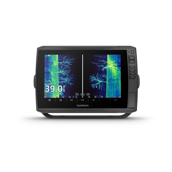
With big, crisp, sunlight-readable touchscreen displays, these versatile chartplotters put a world of fishfinding capability at your fingertips. Theyre available with built-in Garmin Navionics+ mapping, and the transducer bundle adds Ultra High-Definition scanning sonars as well as CHIRP traditional sonar.
The ECHOMAP Ultra 2 series supports the full lineup of LiveScope live-scanning sonar products (transducers sold separately).
High-contrast vivid scanning sonar color palettes make it easier than ever to distinguish targets and structure.
Bring a fresh new look and feel to your chartplotter with optional Garmin Navionics Vision+ premium mapping (sold separately), featuring high-resolution relief shading, satellite imagery and more.
If you have another compatible ECHOMAP Ultra 2 or ECHOMAP UHD2 chartplotter on your boat, you can wirelessly share information such as sonar3, waypoints and routes with them.
1LiveScope System sonar transducer sold separately 2Via one-to-one unit wireless connection only 3LiveScope sonar cannot be shared wirelessly between two ECHOMAP Ultra 2 or ECHOMAP UHD2 chartplotters 4Requires the ActiveCaptain app on your compatible smartphone paired to your ECHOMAP Ultra 2 series chartplotter
Specifications
| General | |
| DIMENSION | 13.4" x 9.0" x 3.9" (34.1 x 22.9 x 9.8 cm) |
| WEIGHT | 5.5 lbs (2.5 kg) |
| WATERPROOF | IPX7 |
| TOUCHSCREEN | Yes |
| DISPLAY TYPE | WXGA, IPS |
| DISPLAY SIZE | 10.3" x 6.4"; 12.1" diagonal (26.1 x 16.3 cm; 30.7 cm diagonal) |
| DISPLAY RESOLUTION | 1280 x 800 pixels |
| MOUNTING OPTIONS | Bail or flush |
| INPUT | Touchscreen with Keyed Assist |
| Maps & Memory | |
| ACCEPTS DATA CARDS | 2 microSD cards |
| WAYPOINTS | 5000 |
| TRACK POINTS | 50,000 |
| TRACKS | 50 saved tracks |
| NAVIGATION ROUTES | 100 |
| Sensors | |
| GPS | Yes |
| GLONASS | Yes |
| GALILEO | Yes |
| BEIDOU | Yes |
| HAS BUILT-IN RECEIVER | Yes |
| RECEIVER | 10 Hz |
| NMEA 2000 COMPATIBLE | Yes |
| NMEA 0183 COMPATIBLE | Yes |
| SUPPORTS WAAS | Yes |
| SUPPORTS MULTI-BAND, MULTI-CONSTELLATION GPS | Yes |
| Built-in Maps | |
| BUILT-IN AUTO GUIDANCE+ | Yes |
| GARMIN NAVIONICS+ INLAND & COASTAL | Includes Garmin Navionics+ U.S. Inland & Coastal Mapping |
| TIDE TABLES | Yes |
| Optional Map Support | |
| BLUECHART G3 | Yes |
| BLUECHART G3 VISION | Yes |
| LAKEVü G3 | Yes |
| LAKEVü G3 ULTRA | Yes |
| GARMIN NAVIONICS+ | Yes |
| GARMIN NAVIONICS VISION+ | Yes |
| TOPO 100K | Yes |
| STANDARD MAPPING | Yes |
| GARMIN QUICKDRAW CONTOURS | Yes |
| Electrical Features | |
| POWER INPUT | 9 to 18 Vdc |
| TYPICAL CURRENT DRAW AT 12 VDC | 2.5 A |
| MAXIMUM CURRENT DRAW AT 12 VDC | 5.0 A |
| MAXIMUM POWER USAGE AT 10 VDC | 36 W |
| Connections | |
| NMEA 2000® PORTS | 1 |
| GARMIN MARINE NETWORK PORTS | 2 (large connector) |
| 12-PIN TRANSDUCER PORTS | 12-pin scanning sonar |
| ANT+ (CONNECTIVITY) | Yes |
| GARMIN WI-FI NETWORK (LOCAL CONNECTION) | Yes |
| Sonar Features | |
| DISPLAYS SONAR | Yes |
| POWER OUTPUT | 600 watt |
| TRADITIONAL SONAR (DUAL FREQUENCY/BEAM) | built-in (single channel CHIRP, 70/83/200 kHz, L, M, H CHIRP) |
| CLEARVü | built-in 260/455/800/1000/1200 kHz |
| SIDEVü | built-in 260/455/800/1000/1200 kHz |
| PANOPTIX SONAR | Yes |
| LIVESCOPE | Yes |
Item number: 010-02882-10
UPC: 753759345099
Package weight: 25.20 lb
Other Products in the Series: