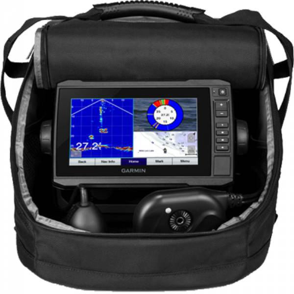
GARMIN EchoMap plus 73cv Ice Bundle w/ GT10, PS22
This item is brand new
$1,614.95
Backorder, ships in 3 - 4 weeks
sw|cw|sw


MotorGuide Adapter Cable 8-pin


Panoptix PS31 Forward Transducer

Panoptix PS60 Thru-hull Down Transducer
Panoptix PS21 LiveVu Forward Transducer
Panoptix PS21-TM Forward Transom Mount Transducer


NMEA 2000 Transducer Adapter Kit

GNT 10 NMEA 2000 - ANT Transceiver


M260-8G 1kW 200/50kHz In-Hull Plastic Transducer


M265LH DO 42 210 kHz 1kW CHIRP In-hull/Pocket Plastic Transducer


R599LH 2-3kW CHIRP Transducer


B175L no connector 1kW 12 tilt CHIRP Bronze Transducer
B175H no connector 1kW 20 tilt CHIRP Bronze Transducer

P72-8G 500W 77/200 kHz Transducer


B175M 8pin1kW 12 tilt CHIRP Transducer

B175M 8pin 1kW 20 tilt CHIRP Transducer


B75H 0 deg tilt CHIRP Transducer


B75L 12 deg tilt CHIRP Transducer


B164 1kW 0 tilt 200/50kHz Bronze Transducer 8-pin


Wide beam bare wires 0 Tilt 150-250 kHz 1kW CHIRP Bronze Transducer
Wide beam bare wires 12 Tilt 150-250 kHz 1kW CHIRP Bronze Transducer
Wide beam bare wires 20 Tilt 150-250 kHz 1kW CHIRP Bronze Transducer
B175H no connector 1kW 0 tilt CHIRP Bronze Transducer
B175H no connector 1kW 12 tilt CHIRP Bronze Transducer
B175L 8pin 1kW 0 tilt CHIRP Bronze Transducer
B175L no connector 1kW 20 tilt CHIRP Bronze Transducer
B175M no connector 1kW 0 tilt CHIRP Bronze Transducer
B175M no connector 1kW 12 tilt CHIRP Bronze Transducer
B175M no connector 1kW 20 tilt CHIRP Bronze Transducer

B265LH CHIRP Transducer
B45-DT-8G Thru-Hull 50/200 kHz Bronz Narrow Stem 8pin Transducer

CM599 LH 2-3kW CHIRP Transducer

CM599 LM 2-3kW CHIRP Pocket Mount Transducer

PM265LM DT 42-135 kHz 1kW CHIRP Poket Bronze Transducer

R109LH 38-210 kHz 2kW CHIRP Urethane Thru-Hull Transducer

R509LH DT 28-210 kHz 2-3kW CHIRP Epoxy Thru-Hull Transducer

R509LM DT 28-130 kHz 2-3kW CHIRP Epoxy Thru-Hull Transducer

SS164 0 deg tilt 1kW Transducer 8pin

SS164 12 deg tilt 1kW Transducer 8 pin

SS164 20 deg tilt 1kW Transducer 8 pin


P32-8G DST 77/200 Khz 45/15 beam Transom Mount 8pin Triducer

TM150M 95-155 kHz Trunsom mount Plastic CHIRP 8pinTransducer
GT21-TM - Transom Mount DownVu 500W CHIRP 260/455 kHz Traditional 600W 50/200 kHz Transducer w/Temp


TM265LH DT 42-210 Khz 1kW CHIRP Urth Transom Transducer

For Garmin TM258-8G DT Cone 3-21 1kW 200/50kHz Transom 8pin Transducer
Suggested Maps and Software:
 | Inland Lakes |
 | BlueChart g2, g3 Vision |
 | BlueChart g2, g3 on micro SD card with adapter |
 | Garmin Extras |
 | LakeVu HD Ultra |
 | LakeVu HD |
Contents of the package
Features
Echomap Plus 73cv Ice Bundle, MFG# 010-01893-20, with GT10HN-IF & Panoptix PS22 Xdcrs, bag, battery, charger. 7 in LCD, internal GPS, US LakeVU HD maps. Sonar: 500 Watts, 50/77/83/200 KHz, CHIRP L/M/H, 260/455/800 KHz ClearVu down-imaging. WiFi/NMEA 2000.Specifications
Item number: 010-01893-20
UPC: 753759215286
Package weight: 25.80 lb