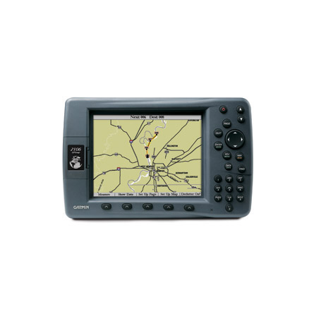
GARMIN Gpsmap 2106
This item is brand new
$1,599.99
This item ships within 9 days


16 MB data card, RoHS

32 MB data card, RoHS

64 MB data card, RoHS

128 MB data card, RoHS

256 MB data card, RoHS

512 MB data card, RoHS


Suggested Maps and Software:
 | BlueChart on Garmin Datacard |
 | Garmin Extras |
 | nuMaps Updates |
Contents of the package
- GPSMAP 2106
- Basemap: Worldwide Marine
- GPS 17 WAAS-enabled sensor
- Bail mount
- Protective cover
- Power/data cable
- CANet cable
- Owner's manual
- Quick reference guide
Features
For worldwide capability in an affordable big picture chartplotter, this is the GPSMAP series for you. Whether you choose the crisp 6.4-inch diagonal screen on the GPSMAP 2106, or the larger 10-inch display on the 2110, these large-format, non-network navigators offer great picture clarity and readability, even in direct sunlight. An enhanced worldwide basemap depicts shorelines, highways and surface features in rich, colorful detail while GPS tracks your position with graphical bearing and course guidance.
Although not preloaded with detailed cartography, the units will accept the new BlueChart® g2 series data cards. This new generation of BlueChart features a smoother layering and better integration of map graphics for easy panning, scrolling and zooming. It also offers a choice between a 3D "mariner's-eye-view", or the familiar 2D direct-overhead view to help you better visualize your way around busy harbors, navaids or tricky coastlines.
Specifications
noneItem number: 010-00535-00
UPC: -
Package weight: 7 lb
Other Products in the Series:
 | GARMIN Gpsmap 172 | |
 | GARMIN GPSMAP 172c | |
 | GARMIN Gpsmap 176 | |
 | GARMIN Gpsmap 178 | |
 | GARMIN GPSMAP 178c | |
 | GARMIN Gpsmap 182 | |
 | GARMIN Gpsmap 188 | |
 | GARMIN GPSMAP 192c | |
 | GARMIN Gpsmap 196 | |
 | GARMIN GPSMAP 198c | |
 | GARMIN Gpsmap 2206 | |
 | GARMIN Gpsmap 2210 | |
 | GARMIN Gpsmap 232 | |
 | GARMIN Gpsmap 238 | |
 | GARMIN Gpsmap 292 | |
 | GARMIN Gpsmap 295 | |
 | GARMIN Gpsmap 298 | |
 | GARMIN Gpsmap 398 | |
 | GARMIN Gpsmap 492 | |
 | GARMIN StreetPilot III |