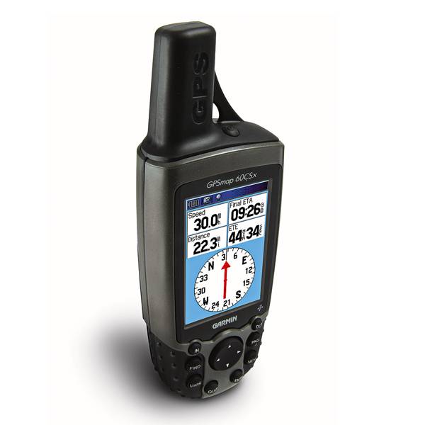
GARMIN GPSMAP 60CSx


AC adapter, USA, 4 Pin

GA 30 GPS antenna (GA 29 replacement)
GA 27C low-profile remote automobile antenna

GA 25MCX low profile remote GPS antenna


Cup Holder Universal Mount RAM-A-CAN II with 6 in Flex Arm


Suggested Maps and Software:
 | Inland Lakes |
 | BlueChart g2, g3 on micro SD card with adapter |
 | Garmin Street Maps and City Navigation |
 | Garmin Topographic Maps |
Contents of the package
Features
Hardworking, rugged handheldelectronic compass, barometric altimeter, high-sensitivity GPS receiver, color display, microSD card slot, 64 MB microSD card
Specifications
Physical & Performance:
Unit dimensions, WxHxD: 2.4" x 6.1" x 1.3" (6.1 x 15.5 x 3.3 cm)
Display size, WxH: 1.5" x 2.2" (3.8 x 5.6 cm)
Display resolution, WxH: 160 x 240 pixels
Display type: 256 level color TFT
Weight: 7.5 oz (213 g) with batteries
Battery: 2 AA batteries (not included)
Battery life: 18 hours, typical
Waterproof: yes (IPX7)
Floats: no
High-sensitivity receiver: yes
Interface: serial and USB
RoHS version available: yes
Maps & Memory:
Basemap: yes
Preloaded maps: no
Ability to add maps: yes
Built-in memory: no
Accepts data cards: 64 MB microSD card (included)
Waypoints/favorites/locations: 1000
Routes: 50
Track log: 10,000 points, 20 saved tracks
Features:
Automatic routing (turn by turn routing on roads): yes
Electronic compass: yes
Touchscreen: no
Barometric altimeter: yes
Geocaching-friendly: yes
Outdoor GPS games: yes
Hunt/fish calendar: yes
Sun and moon information: yes
Tide tables: no
Area calculation: yes
Custom POIs (ability to add additional points of interest): yes
Unit-to-unit transfer (shares data wirelessly with similar units): no
Picture viewer: no
Item number: 010-00422-00
UPC: 753759049126
Package weight: 2 lb
Following reviews were written by actual customers.
Every GPS4US customer has a chance to live a feedback after receiving a product.
 by tengku I, , 11/16/2011
yes
by steve C, , 11/12/2011Absolutely fantastic piece of equipment. I use it solely for hunting.
by Daniel G, , 7/18/2011Very strong signal. The best GPS unit.
by Manon M.N. P, , 7/9/2011works great! Am using this receiver for geocaching. just love it.
by Daniel G, , 6/1/2011Strong signal.Very reliable at good price.
by Daniel G, , 5/9/2011The best outdoor GPS and the GPS4US staff was very kind.Thanks
by bogdan A, , 4/23/2011Very high accuracy, efficient power consumption, lightweight, complex trip data analysis.Reliable mountaineering gear
by khir R, , 3/21/2011love at all
by สวัà¸à¸£à¸ รà¸à¹ À, , 12/17/2010 by สวัà¸à¸£à¸ รà¸à¹ À, , 12/17/2010Other Products in the Series:
| GARMIN Gpsmap 60 | Add to comparison |
| GARMIN Gpsmap 60Cs | Add to comparison |
| GARMIN GPSMAP 60CSx NOH | |
| GARMIN GPSMAP 60Cx | Add to comparison |
| GARMIN GPSMAP 60Cx NOH |