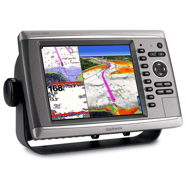
GARMIN Gpsmap 6208


GPS 17x NMEA 2000 GPS Receiver

GPS 17x GPS Receiver

GPS 19x NMEA 2000 GPS Receiver


GXM 52 - SiriusXM Marine Receiver

Gdl 30A

GDL 40 Weather Receiver

GXM 51 - Weather and Audio XM Receiver

GHP 10 Marine Autopilot System with GHC 20

GHP 10 Marine Autopilot System with GHC 10

GHP 10V Marine Autopilot System with GHC 10

GHP 10V Marine Autopilot System with GHC 20


GHP 12 Sailboat Autopilot System with GHC 10

GHP 20 Marine Autopilot System for Steer-by-Wire with GHC 10

GHP 20 Marine Autopilot System for Viking with GHC 10


GHP 20 Marine Autopilot System for Yamaha Helm Master with GHC 10


GHP 20 Marine Autopilot System with SmartPump and GHC 10


GHP Reactor Hydraulic Autopilot Corepack

GHP Reactor Mechanical Retrofit Solenoid Corepack

GHP Reactor Hydraulic Corepack with SmartPump

GHP Reactor Steer-by-wire Standard Corepack

GHP Reactor Steer-by-wire Corepack for Yamaha Helm Master

GHP Reactor Steer-by-wire Corepack for Viking VIPER

GHP Reactor Steer-by-wire Corepack for Volvo-Penta

GHP Compact Reactor Hydraulic Autopilot Starter Pack


GSD 26 Digital Sonar

GSD 22 Digital Sonar


Ais 300

Ais 600

VHF 100i Black

VHF 100 Silver Grey
VHF 100i International

VHF 200 Silver Gray

VHF 200i Black
VHF 200i International

VHF 300 Silver Gray
VHF 300i International

VHF 300i Black

VHF 300i AIS Black
VHF 300 AIS Silver Gray
VHF 300i AIS International


Split Connector 50ft Right Angle RJ45 Plug


NMEA 2000 Transducer Adapter Kit

GNT 10 NMEA 2000 - ANT Transceiver

GMR 18 HD Radar

GMR 18 xHD Radar


GMR 604 xHD Open Array and Pedestal

GMR 606 xHD Open Array and Pedestal
GMR 1204 xHD Open Array and Pedestal
GMR 1206 xHD Open Array and Pedestal

GMR 404/406 Radar Pedestal

GMR 404 Open Array Radar

GMR 406 Open Array Radar

GMR 18 Radar

GMR 24 Radar

GMR 18 HD Plus Radar

GMR 24 HD Radar

GMR 406 xHD Open Array Radar and Pedestal

GMR 424 xHD2 Open Array Radar and Pedestal

GMR 624 xHD2 Open Array Radar and Pedestal

GMR 626 xHD2 Open Array Radar and Pedestal

GMR 1224 xHD2 Open Array Radar and Pedestal

GMR 1226 xHD2 Open Array Radar and Pedestal


GC 10 NTSC Marine Camera
GC 10 NTSC Reverse Marine Camera

GWind, GMI 20, DST800 Bundle


GWind, GMI 20, GNX 20, DST800 Bundle

GWind, GMI 20, DST800, GNX 20 Wireless Bundle


GC 10 PAL Marine Camera
GC 10 PAL Reverse Marine Camera

GCL 20 NTSC Low-light Imaging Camera

GCT 20 QVGA 30Hz Thermal Imaging Camera

GCT 30 VGA 9Hz Thermal Imaging Camera
GCL 20 PAL Low-light Imaging Camera
GCT 20 QVGA 9Hz Thermal Imaging Camera
GCT 30 VGA 30Hz Thermal Imaging Camera

Gmi 10


GNX Wind Wired Sail Pack

GWS 10 Wind Sensor with GMI 20 Bundle

GWS 10 Wind Sensor with GMI 20 and DST800 Bundle

GWS 10 Wind Sensor with GMI 10 and Smart Triducer Bundle

GWS 10 Wind Sensor

GWS 10 Wind Sensor with GMI 10 Bundle


GWind Wireless Transducer


GWind, GMI 20, DST800 Wireless Bundle


Airmar Smart Triducer, Plastic Thru, NMEA 2000

Access, Smart Transducer, P39 Transom, Temp, NMEA 2000


DT800 12 tilt NMEA2000 Smart Transducer Plastic


Suggested Maps and Software:
 | Inland Lakes |
 | BlueChart g2, g3 Vision |
 | BlueChart g2, g3 on micro SD card with adapter |
 | Garmin Extras |
 | LakeVu HD |
Contents of the package
- GPSMAP 6208
- Top & bottom snap covers
- Bail mount & knobs
- GPS 17x NMEA 2000 (with pole mount, flush mount and under deck mount adapters)
- Protective front cover
- Power cable
- Video cable
- NMEA 0183 cable
- NMEA 2000 drop cable
- NMEA 2000 10 m backbone cable
- NMEA 2000 power cable
- NMEA 2000 T-connector & terminator kit
- Flush mount hardware
- Flush mount gasket
- Marine grommet kit
- Manual case
- Manual case with user documentation
Features
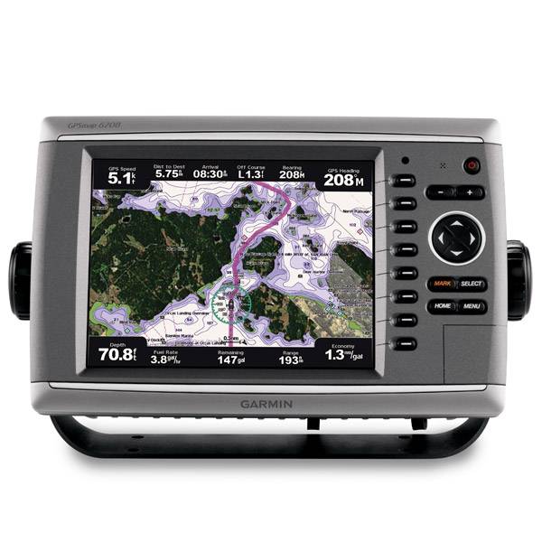
Unleash a new level of power across your helm with the GPSMAP 6208. This premier chartplotter is the next evolution in Garmins series of full-featured marine products. The GPSMAP 6208 comes standard with preloaded BlueChart® g2 maps of the U.S. coast as well as video-quality resolution on an 8.4 VGA display. The GPSMAP 6208 also provides total system integration allowing support for the addition of sonar, radar, weather and more. For additional enhanced features, you can add the optional BlueChart® g2 Vision® card.
Designed to MoveThe GPSMAP 6208 brings unprecedented speed to your vessel with Garmin G MotionTM technology the future of marine technology today. With blazing-fast map redraw and refresh rates, youll have near real-time data to guide you. Whether youre in a crowded harbor or in uncertain weather, youll have the confidence you need to navigate your surroundings with the GPSMAP 6208 as your guide. The GPSMAP 6208 is also compatible with an optional remote for added flexibility. And with a sleek and stylish design that was built to brave the elements, the GPSMAP 6208 looks great in any helm.
View Detailed Graphics and Video
The GPSMAP 6208 features highly detailed BlueChart g2 marine cartography of the coastal United States, including Alaska, Hawaii and the Bahamas. And for more detail, you can easily add maps with the SD card slot without having to connect to a computer. The GPSMAP 6208s high-speed processor draws maps quickly, and its simple intuitive interface makes navigating easy. To keep tabs on your engine room or other area of your boat, you can also connect a live video feed with the GPSMAP 6208s video input and output options. The GPSMAP 6208 also comes standard with a wide range of brightness options - from sunlight-readable to low-light conditions, you can adjust the setting to match the your conditions.
Add Extras with BlueChart g2 Vision
With the optional BlueChart g2 Vision SD card, you can add a whole new dimension of exceptional features to your chartplotter.
- MarinerEye view and FishEye view provide you a 3-dimensional perspective of map information, both above and below the waterline.
- High-resolution satellite images and aerial photographs help you orient yourself in unfamiliar areas.
- Auto Guidance technology searches through all relevant charts to create a route you can actually follow one that avoids obstacles, shallow water, buoys and other obstructions.
Connect to your network
The GPSMAP 6208 easily connects to your network - providing system integration so you can interface with additional MFDs and add remote sensors. Once connected, you can share information between the GPSMAP 6008 and other chartplotters on your boat. You can also add high-powered radar, sonar and XM satellite weather and radio to your system.


Specifications
Physical & Performance:
Unit dimensions, WxHxD: 11.5" x 7.4" x 5.9" (29.2 x 18.9 x 14.9 cm)
Display size, WxH: 6.8" x 5.1", 8.4" diagonal (17.1 x 13 cm, 21.3 cm diagonal)
Display resolution, WxH: 640 x 480 pixels
Display type: VGA display
Weight: 11.3 lb (5.1 kg)
Battery: none
Battery life: none
Waterproof: yes (IPX7)
High-sensitivity receiver: yes
Antenna: external
NMEA input/output: NMEA 0183, NMEA 2000
Maps & Memory:
Basemap: yes
Preloaded maps: yes (coastal maps)
Ability to add maps: yes
Built-in memory: none (cannot load maps to internal memory)
Accepts data cards: SD card slot (BlueChart g2 Vision cards sold separately)
Waypoints/favorites/locations: 5,000
Routes: 100
Track log: 50,000 points; 50 saved tracks
Features:
Garmin radar compatible: yes
Garmin sonar compatible: yes
Garmin Marine Network compatible: yes
Touchscreen: no
Supports AIS (tracks target ships' position): yes
Supports DSC (displays position data from DSC capable VHF radio): yes
Audible alarms: yes
Tide tables: yes
Hunt/fish calendar: no
Sun and moon information: yes
3-D map view: yes (with optional BlueChart g2 Vision card)
Auto Guidance: yes (with optional BlueChart g2 Vision card)
XM WX Weather & Radio for U.S. & Canada compatible: yes
Automatic routing (turn by turn routing on roads): no
Voice prompts (e.g. "Turn right in 500 ft."): no
Speaks street names (e.g. "Turn right ON ELM STREET in 500 ft."): no
Headphone jack/audio line-out: no
Audio/video input/output: yes
Portable: no
Automotive/motorcycle-friendly: no
Additional: Interface Inputs/Outputs: 4 NMEA 0183 inputs, 2 NMEA 0183 outputs; 2 video inputs for onboard cameras, 1 PC monitor video output
Item number: 010-00750-01
UPC: -
Package weight: 20 lb