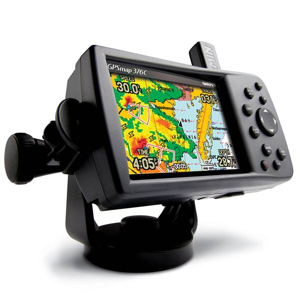
GARMIN Gpsmap 376C


This item is brand new
$559.99
This item ships within 9 days


GA 26C low-profile remote automobile antenna

GA 30 GPS antenna (GA 29 replacement)
GXM 30 - XM Traffic Receiver
Lithium Ion battery pack (replacement)


16 MB data card, RoHS

32 MB data card, RoHS

64 MB data card, RoHS

128 MB data card, RoHS

256 MB data card, RoHS
512 MB data card, RoHS


Suggested Maps and Software:
 | BlueChart on Garmin Datacard |
 | Garmin Extras |
 | nuMaps Updates |
Contents of the package
Features
The GPSMAP 376C is perfect for land or water. This portable navigator features a sunlight-readable 256-color TFT display and a built-in autorouting basemap that can route you on major interstates and highways.
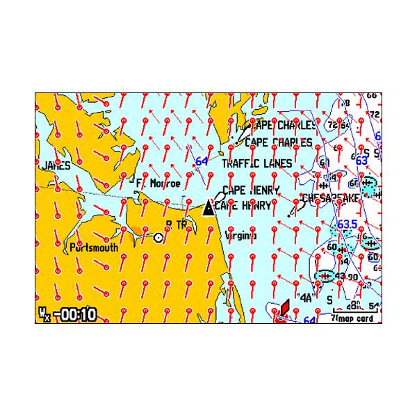
On water, the GPSMAP 376C is a dependable color chartplotter with built-in basemap enhanced by Garmin's marine cartography. 376C has a Course Deviation Indicator (CDI) a feature normally found on aircraft. The CDI quickly indicates whether your boat has veered off-course and helps you get back on track quickly. The 376C also supports external NMEA sources for water depth, water temperature, and water speed through two serial interfaces.
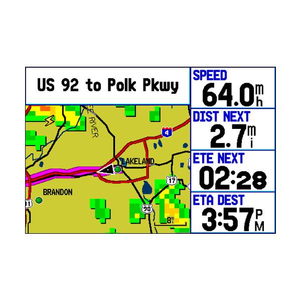
On land, the GPSMAP 376Cs autoroute basemap can route you on interstates and major highways. For even more detail, get the optional automotive kit (sold separately), which includes City Navigator detailed maps, a data card and an automotive mount. With this kit, just load the detailed street maps on your 376C and pop it into the automotive mount for voice-prompted turn-by-turn directions to over six million addresses and points of interest, including restaurants, hotels, gas stations, marinas and other attractions.
Get XM Satellite Weather
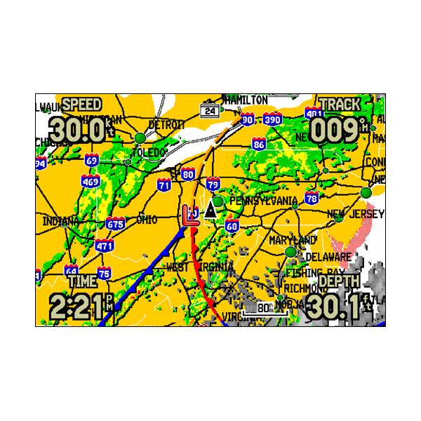
See real-time weather on the 376C's high-resolution TFT with the included GXM 30 XM antenna and a subscription to XM Satellite Weather and Radio services. View vital weather data, including NEXRAD radar, storm cells, wind speeds, surface temperatures, forecasts and more than a dozen other weather attributes, so you can enjoy the water without worrying about the weather. You can also subscribe to XM Satellite Radio to receive over 100 channels of commercial-free music, sports, news and talk radio.
Add More Marine Maps
The 376C is compatible with BlueChart® maps, which add extra detail when you're out on the seas. It also accepts optional MapSource® data cards, so you can add other types of map data easily. For convenience and easy map transfer, you can connect the 376C to your computer with the included USB cable.


Specifications
Physical & Performance:
Unit dimensions, WxHxD: 5.7" x 3.2" x 1.9" (14.5 x 8.1 x 4.8 cm)
Display size, WxH: 3.0" x 2.2" (7.6 x 5.6 cm)
Display resolution, WxH: 480 x 320 pixels
Display type: 256-color TFT
Weight: 13.6 oz (385 g)
Battery: rechargeable internal lithium-ion
Battery life: up to 15 hours
Waterproof: yes (IPX7)
Antenna: detachable
NMEA input/output: NMEA 0183
RoHS version available: no
Maps & Memory:
Basemap: yes
Preloaded maps: no
Ability to add maps: yes
Built-in memory: none (cannot load maps to internal memory)
Accepts data cards: Garmin data cards
Waypoints/favorites/locations: 3,000
Routes: 50
Track log: 10,000 points; 20 saved tracks
Features:
Garmin radar compatible: no
Garmin sonar compatible: yes
CANet® compatible: no
Garmin Marine Network compatible: no
Touchscreen: no
Supports AIS (tracks target ships' position): no
Supports DSC (displays position data from DSC capable VHF radio): yes
Audible alarms: yes
Tide tables: yes
Hunt/fish calendar: yes
Sun and moon information: yes
3-D map view: no
Auto Guidance: no
Automatic routing (turn by turn routing on roads): yes
XM WX Weather & Radio for U.S. compatible: yes
Voice prompts (e.g. "Turn right in 500 ft."): no
Remote control: no
Headphone jack/audio line-out: yes
Audio/video input/output: no
Portable: yes
Automotive/motorcycle-friendly: yes
Item number: 010-00438-00
UPC: 753759049010
Package weight: 4.3 lb
Other Products in the Series:
| GARMIN Gpsmap 276C | Add to comparison |
| GARMIN GPSMAP 276C Plus NOH | |
| GARMIN Gpsmap 278 | Add to comparison |
| GARMIN Gpsmap 296 | |
| GARMIN Gpsmap 376C NOH | |
| GARMIN Gpsmap 378 NOH | |
| GARMIN Gpsmap 378 | Add to comparison |
| GARMIN Gpsmap 396 | |
| GARMIN Gpsmap 478 | Add to comparison |
| GARMIN Gpsmap 478 NOH | |
| GARMIN Gpsmap 495 | |
| GARMIN Gpsmap 496 | |
| GARMIN GPSMAP 498 with transducer External antenna | Add to comparison |