GARMIN Gpsmap 640


GXM 40 - XM Traffic Receiver

Li-Ion battery pack

Carrying case

Protective cover


Cradle Adapter with G-Ball
Suggested Maps and Software:
 | Inland Lakes |
 | BlueChart g2, g3 Vision |
 | BlueChart g2, g3 on micro SD card with adapter |
 | Garmin Street Maps and City Navigation |
 | Garmin Topographic Maps |
 | Garmin Extras |
Contents of the package
- GPSMAP 640
- Preloaded BlueChart® g2 marine charts of the coastal U.S
- Preloaded City Navigator NT North America maps (U.S. and Canada) and worldwide satellite basemap
- Marine mount with power/data cable
- Automotive mount with integrated vehicle power cable
- Automotive friction mount
- Lithium-ion battery pack
- USB cable
- Protective cover
- Owner's manual
- Quick reference guide
- Installation instructions
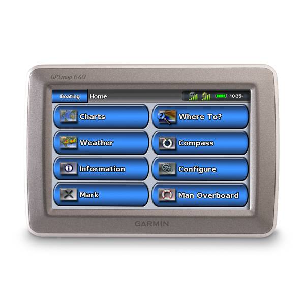
Features
The Garmin GPSMAP 640 will make your life easier on both the water and the road. Itspreloaded with BlueChart g2 data and City Navigator North American road maps, so
youll always know where youre headed. Plus, the GPSMAP 640 gives you a
high-sensitivity GPS receiver with a vivid high-resolution touchscreen display. In
marine mode, your device can receive XM and WX satellite weather data, and CM
NavTraffic data makes automotive mode a breeze with the optional GXM 40 antenna and
an XM subscription.
When you use the marine mount, you get easy access to your marine data. And, when you
use the optional automotive mount and City Navigator NT for North America map data,
your GPSMAP 620 automatically shifts to automotive mode. The GPSMAP 640 has a vivid
5.2-inch WNGA touchscreen display and an easy-to-use interface. Its also preloaded
with a worldwide satellite basemap so youll see vivid space images of all the
surface features around you.
When youre on your boat, the GPSMAP 640 gives you both Mariners and Fish eye view,
which lets you see whats going on both above and below the waterline. The Auto
Guidance feature searches chart data to offer you the best passage through BlueChart
g2 Vision data. The GPSMAP 640 is NMEA-0183 compliant, so you can add it to an
existing marine network. Plus, youll always be on point with access to fishing
charts, tide and current data, marine services coastal roads and more with the
BlueChart g2 Vision data. And, the worldwide basemap comes standard on your GPSMAP
640.
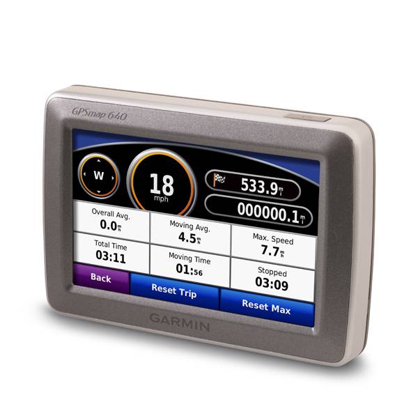
When youre back in your car, GPSMAP 640s automotive mode tells you where to go with
turn-by-turn directions. And, route planning is easy, so youll have no problem
planning your trip. Use your GPSMAP 640 to create custom points of interest and set
up proximity alerts so you know whats ahead before you get there.


Specifications
Physical & Performance:
Unit dimensions, WxHxD: 5.9"W x 4"H x 1.9"D (15.0 x 10.2 x 4.8 cm)
Display size, WxH: 4.5"W x 2.7"H (11.4 x 6.9 cm); 5.2" diag (13.2 cm)
Display resolution, WxH: 800 x 480 pixels
Display type: WVGA
Weight: 17.3 ounces (490.4 g)
Battery: rechargeable lithium-ion
Battery life: up to 9 hours
Waterproof: yes (IPX7)
Antenna: internal
NMEA input/output: NMEA 0183
RoHS version available: yes
Maps & Memory:
Basemap: yes
Preloaded maps: yes (coastal and detailed road maps)
Ability to add maps: yes
Built-in memory: internal solid state
Accepts data cards: SD card slot
Waypoints/favorites/locations: 1500 (marine mode); 1000 (automotive mode)
Routes: 50 (marine mode); 10 (automotive mode)
Track log: 10,000 points, 20 saved tracks (marine mode); 10,000 points, no saved tracks (automotive mode)
Features:
Garmin radar compatible: no
Garmin sonar compatible: no
CANet® compatible: no
Garmin Marine Network compatible: no
Touchscreen: yes
Supports AIS (tracks target ships' position): yes
Supports DSC (displays position data from DSC capable VHF radio): yes
Audible alarms: yes
Tide tables: yes
Hunt/fish calendar: no
Sun and moon information: yes
3-D map view: yes (with optional BlueChart g2 Vision card)
Auto Guidance: yes (with optional BlueChart g2 Vision card)
Automatic routing (turn by turn routing on roads): yes
XM WX Weather & Radio for U.S. compatible: yes
Voice prompts (e.g. "Turn right in 500 ft."): yes (12v/speaker)
Speaks street names (e.g. "Turn right ON ELM STREET in 500 ft."): yes
Remote control: no
Headphone jack/audio line-out: yes
Audio/video input/output: no
Portable: yes
Automotive/motorcycle-friendly: yes
Item number: 010-00696-60
UPC: 753759117962
Package weight: 5 lb
Following reviews were written by actual customers.
Every GPS4US customer has a chance to live a feedback after receiving a product.
 by Aleksey Z, , 12/3/2015
Super
Other Products in the Series:
| GARMIN Gpsmap 620 | Add to comparison |
| GARMIN Gpsmap 620 NOH | |
| GARMIN Gpsmap 640 NOH |