GARMIN Overlander


Item: 010-02195-00
This item is brand new
$699.99
This item ships within 1 day
an|cw|sw|ln


This item is brand new
$699.99
This item ships within 1 day
an|cw|sw|ln
Adapters Chargers


Cables


Cases and Covers

010-11917-00
Universal 7 inch soft carrying case
Universal 7 inch soft carrying case
No Longer Available
Memory

Mounts


010-10908-00
Portable Friction Mount
Portable Friction Mount
No Longer Available


010-12944-00
RAM Ball Adapter With AMPS Plate
RAM Ball Adapter With AMPS Plate
Out of stock

010-12943-00
Suction Cup with Magnetic Mount
Suction Cup with Magnetic Mount
Out of stock

RAM Mounts Build your own


RAP-299-2U
Cup Holder Universal Mount RAM-A-CAN II with 6 in Flex Arm
Cup Holder Universal Mount RAM-A-CAN II with 6 in Flex Arm
No Longer Available


RAM-HOL-GA22U
Cradle Adapter with G-Ball
Cradle Adapter with G-Ball
Out of stock
Traffic Receivers

010-01031-00
GTM 60 HD Digital Traffic Receiver and Power Cable, Open box
GTM 60 HD Digital Traffic Receiver and Power Cable, Open box
No Longer Available

010-01009-02
GTM 36 lifetime traffic
GTM 36 lifetime traffic
Out of stock
Compatible maps
Suggested Maps and Software:
 | Garmin Street Maps and City Navigation |
 | Garmin Topographic Maps |
Contents of the package
Overlander
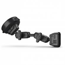
Vehicle suction cup mount
RAM ball adapter with AMPS plate
Vehicle power cable
USB cable
Documentation
Vehicle suction cup mount
RAM ball adapter with AMPS plate
Vehicle power cable
USB cable
Documentation
Features
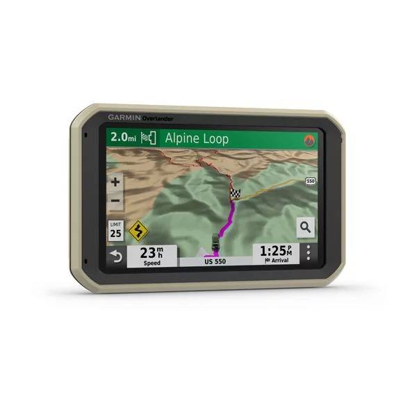
Roam the UnknownBuilt for every part of the journey, Overlander is a rugged, all-terrain navigator that can easily switch from turn-by-turn directions for on-road navigation to topography maps for off-grid guidance in North and South America.
Overlander features integrated pitch and roll angles as well as a compass, altimeter and barometer to help you and your vehicle navigate difficult terrain. A built-in rechargeable battery means you can even take it beyond your vehicle.
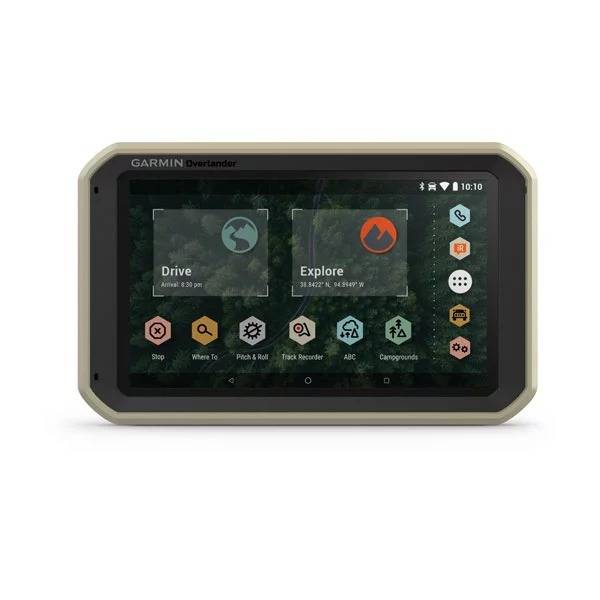
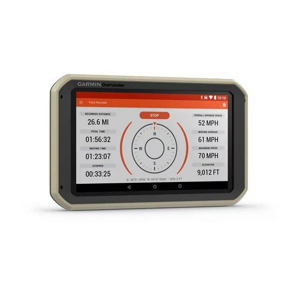
Create a Garmin Explore account to plan and map out your next adventure. You can easily record and create routes by tapping the screen on your Overlander navigator. Use your account to wirelessly sync via Wi-Fi® connectivity¹ your tracks, routes and waypoints across all your devices.
On/Off Road
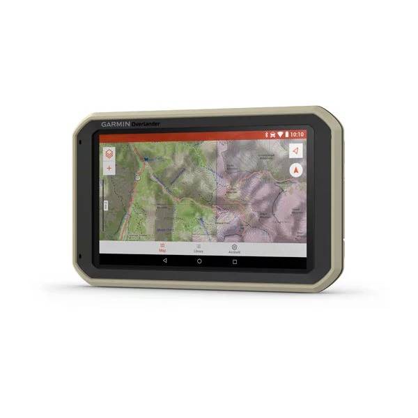
7 color touchscreen features turn-by-turn directions for on-road navigation and topography maps for off-road guidance covering North and South America.
Garmin Explore
Use the Garmin Explore app to download additional maps and USGS quad sheets on 64 GB of storage, and sync all of your data between devices¹.
Find Campsites
Preloaded with iOverlander points of interest (POIs) and Ultimate Public Campgrounds, so you dont need a cell signal to find the best-established, wild and dispersed campsites.
Find Boundaries
Features topographic maps with public land boundaries and 4x4 roads.
Know Your Vehicle
Routing is based on height, weight and length for large overlanding vehicles.
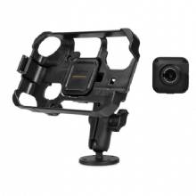
RAM Mounted
Can be mounted anywhere with a powered magnetic mount that comes with a suction cup or RAM-compatible adapter.
InReach Compatible
Pairs with inReach satellite communicators² (sold separately) for two-way text messaging, interactive SOS and weather forecasts.
BC 35 Compatible
Pairs with up to four BC 35 backup cameras (sold separately) so you can see whats behind you.
Multi-GNSS Support
GPS, GLONASS and Galileo support helps track in more challenging environments than GPS alone.
¹Requires an active Wi-Fi connection
²Active satellite subscription required for inReach device
Wi-Fi is a registered trademark of the Wi-Fi Alliance.
Specifications
General | |
| Physical dimensions | 7.84" W x 4.79" H x 0.93" D (19.9 x 12.2 x 2.4 cm) |
|---|---|
| Display size | 6.0" W x 3.5" H (15.2 x 8.9 cm); 6.95" (17.7 cm) |
| Display resolution | 1024 x 600 pixels |
| Display type | multi-touch, glass, WSVGA color TFT with white backlight |
| Weight | 15.4 oz (437 g) |
| Battery | rechargeable lithium-ion |
| Battery life | up to 3 hours |
| Drop rating | MIL-STD-810 |
| Dust rating | IP5X |
| Magnetic Mount | |
| AMPS plate RAM ball adapter | |
Maps & Memory | |
| Preloaded street maps | |
|---|---|
| 3D Terrain | |
| Downloadable satellite imagery | Yes (U.S. only) |
| Downloadable USGS Quad Sheets | |
| Includes map updates | |
| Internal storage | 64 GB |
| Data cards | microSD card (not included) |
Sensors | |
| GPS | |
|---|---|
| GLONASS | |
| Galileo | |
| Barometric altimeter | |
| Compass | |
Outdoor Recreation Features | |
| Preloaded topographical maps | |
|---|---|
Camera Features | |
| Backup camera compatible | yes (BC 35) |
|---|---|
Navigation Features | |
| Garmin Real Directions landmark guidance | |
|---|---|
| Millions of Foursquare® points of interest | |
| TripAdvisor® ratings for points of interest | |
| Route shaping through preferred cities/streets | |
| Voice-activated navigation (operate device with spoken commands) | |
| Includes traffic | no (optional traffic cable accessory) |
| Lane assist with junction view (displays junction signs) | |
| Bluetooth® calling | |
| Speed limit indicator (displays speed limit for most major roads in the U.S. and Europe) | |
| Driver alerts for sharp curves, school zones, red light and speed camera warnings and more | |
Advanced Features | |
| Wi-Fi® map and software updates | |
|---|---|
RV Features | |
| Specialized RV routing | |
|---|---|
| RV Parks & Services directory | |
| Road elevations | |
| Speed limit changes | |
| State border notices - RV | |
| Sunrise/sunset times - RV | |
| Mile marker info - RV | |
Overlanding Features | |
| Pair with compatible inReach® devices | |
|---|---|
| Track recorder (breadcrumbs) | |
| Compatible with Garmin Explore for waypoints, tracks, route and activities | |
| iOverlander points of interest | |
| Ultimate Public Campgrounds | |
| Pitch and Roll gauges | |
Item number: 010-02195-00
UPC: 753759235109
Package weight: 2 lb