GARMIN Tread - Base Edition


Item: 010-02406-01
This item is brand new
$609.95
This item ships within 1 day
|sw|pe


This item is brand new
$609.95
This item ships within 1 day
|sw|pe
Adapters Chargers

Antennas

010-12998-12
Long-range Antenna with Tube Mount Kit
Long-range Antenna with Tube Mount Kit
Out of stock
Cables


010-12998-02
High-Current Power Cable
High-Current Power Cable
Out of stock

010-12998-03
Auto Accessory Kit
Auto Accessory Kit
Out of stock
Mounts


Various


Compatible maps
Also available


Suggested Maps and Software:
 | Inland Lakes |
 | Garmin Street Maps and City Navigation |
 | Garmin Topographic Maps |
 | Garmin Extras |
Contents of the package
Tread
Trim ring kit (blue, black, red and green)
Tube mount kit
Power cable
USB cable
Documentation
Trim ring kit (blue, black, red and green)
Tube mount kit
Power cable
USB cable
Documentation
Features
ROAM THE UNKNOWNThis rugged powersport GPS navigator keep you on track.
Take your side-by-side off the beaten path with topographic mapping, private and public land info, forest service roads and trails.
The rugged Tread off-road GPS is IPX7 weather-resistant and features a glove-friendly 5.5 touchscreen display.
Use the Tread® app1 to sync data across your various devices.
Direct-to-device BirdsEye Satellite Imagery can be downloaded to Tread without a computer.
Easily install on your powersport vehicle with the included powered mount and wiring harness with tube mount.
.
OFF-ROAD RUGGEDNESS
Purpose-built for all-terrain use, Tread stands up to anything the elements can throw at it. Its IPX7-rated for water-resistance and built to U.S. military standard 810 for thermal and shock resistance.
HIGH-VISIBILITY DISPLAY
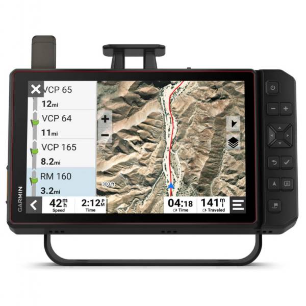
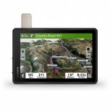
With its ultrabright 5.5 glove-friendly touchscreen, the Tread navigator is designed for easy viewing in bright sunlight or pitch dark. It can be mounted in portrait or landscape mode.
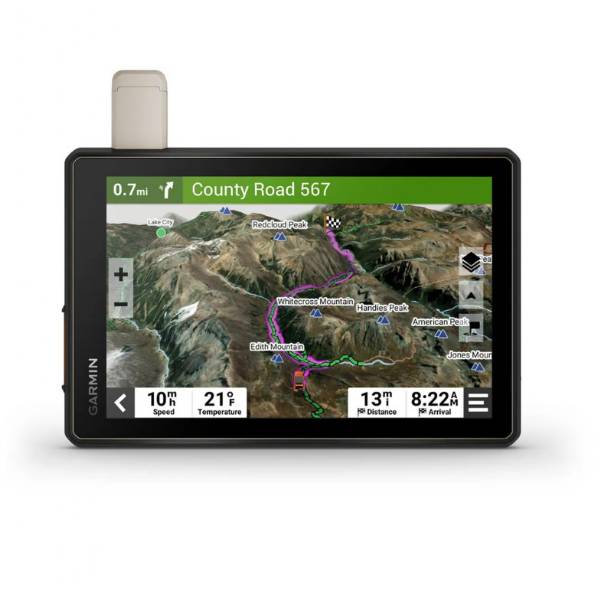
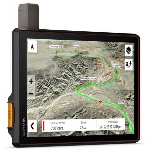
TRAIL NAVIGATION
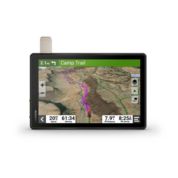
Enjoy turn-by-turn trail navigation2 for traversing unpaved roads and trails using Adventure Roads and Trails map content comprised of OpenStreetMap and USFS Motor Vehicle Use Maps.
MAPS FOR OFF-ROAD
Tread features preloaded topographic maps of North and Central America and detailed street maps of North America. It also includes U.S. Forest Service Roads and trails and Motor Vehicle Use Maps (MVUM) for full-sized 4x4s, side-by-side, ATVs and motorcycles.
SATELLITE IMAGERY
Download high-resolution BirdsEye Satellite Imagery directly via Wi-Fi® connectivity, with no annual subscription required.
KNOW YOUR BOUNDARIES
Access public land boundaries for national forests, Bureau of Land Management (BLM), wilderness areas and more. Also, see private land boundaries and landowner information for parcels greater than 4 acres.
EASILY SYNC YOUR DEVICES
Use the Tread app1 to sync waypoints, tracks, routes and collections across your devices, including your mobile device, computer and Tread navigator. Easily import and share GPX files, too.
MOUNTS WITH MUSCLE
The included powered mount and wiring harness with tube mount secure your Tread navigator to your powersport vehicle for riding over rough terrain.
ABC SENSORS
For tough-terrain guidance, built-in sensors include an altimeter, barometer, compass and pitch/roll gauges.
INREACH® COMPATIBLE
Pair your Tread powersport navigator with one of the compatible inReach global satellite communicators3 (sold separately) for two-way text messaging, interactive SOS and weather.
GO-ANYWHERE GUIDANCE
Get spoken turn-by-turn directions if you choose to take Tread with you when you head back to civilization and want on-road navigation. Includes driver alerts for sharp curves, red light/speed cameras4 and more.
DOG TRACKING
Wirelessly pair Tread with select Garmin GPS dog systems (sold separately) to help track and retrieve your sporting dogs in the field. Youll see markers for each dog within tracking range, overlaid right on the navigators map screen. Directional cues help you easily follow and locate each dog youre tracking.
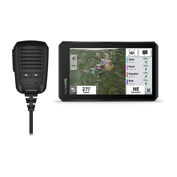
GROUP RIDE MOBILE
Track friends from your compatible smartphone or Tread device when you and your friends use the Tread apps Group Ride mobile feature.
EASY ROUTE PLANNER
Use the Tread app to easily plan routes with the same maps, vehicle profiles and route preferences that you have on the Tread device.
LIVE WEATHER
Weather ahead? Pair Tread with your compatible smartphone, and download the Tread app to access live weather, storm alerts, animated radar and more1.
CONTROL YOUR ACCESSORIES
Pair Tread with the compatible Garmin PowerSwitch digital switch box (sold separately) to enable on-screen control for your side-by-sides 12-volt electronics light bars, differential locks and more.
POINTS OF INTEREST
Tread comes preloaded with iOverlander points of interest and Ultimate Public Campgrounds, so you dont need a cell signal to route to the best-established, wild and dispersed campsites.
ADD A CAMERA
Whats around your side-by-side? Maximize visibility by pairing Tread with a rugged BC 40 wireless camera with tube mount (sold separately). It easily mounts to your vehicles tube frame, flat panel or roll cage.
TRAVELING MUSIC
A built-in media player lets you easily control music loaded on your compatible smartphone on the navigators display and hear your tunes through your helmet or headset (sold separately) enabled with BLUETOOTH technology.
Specifications
GeneralDIMENSION 5.8W x 3.5H x 1D (8.8 x 14.8 x 2.4 cm)
DISPLAY SIZE 4.8W x 2.7H (12.1 x 6.8 cm); 5.5 diagonal (13.9 cm)
DISPLAY RESOLUTION 1280 x 720 pixels
DISPLAY TYPE multi-touch, glass, high brightness HD color TFT with white backlight
DUAL-ORIENTATION DISPLAY
WEIGHT 9.2 oz (262 g)
BATTERY TYPE rechargeable lithium-ion
BATTERY LIFE up to 6 hours (up to 3.5 hours at 100% backlight)
WATERPROOF IPX7
DROP RATING MIL-STD-810
TUBE MOUNT (1.5" - 2.375")
1" BALL ADAPTER WITH AMPS PLATE
PRELOADED STREET MAPS
DATA CARDS microSD card (not included)
3D TERRAIN
INTERNAL STORAGE 32 GB
ABILITY TO ADD MAPS
EXTERNAL MEMORY STORAGE yes (256 GB max microSD card)
INCLUDES MAP UPDATES
DOWNLOADABLE SATELLITE IMAGERY yes (BirdsEye)
GPS
GALILEO
BAROMETRIC ALTIMETER
COMPASS
POINT-TO-POINT NAVIGATION
PRELOADED TOPOGRAPHICAL MAPS
NAVIGATE-A-TRACK NAVIGATION
TURN-BY-TURN TRAIL NAVIGATION
BACKUP CAMERA COMPATIBLE yes (BC 40)
GARMIN REAL DIRECTIONS LANDMARK GUIDANCE
TRIPADVISOR® TRAVELER RATINGS
ROUTE SHAPING THROUGH PREFERRED CITIES/STREETS
INCLUDES TRAFFIC yes (with Garmin Tread app)
LANE ASSIST WITH JUNCTION VIEW (DISPLAYS JUNCTION SIGNS)
SPEED LIMIT INDICATOR (DISPLAYS SPEED LIMIT FOR MOST MAJOR ROADS IN THE U.S. AND EUROPE)
DRIVER ALERTS FOR SHARP CURVES, SCHOOL ZONES, RED LIGHT AND SPEED CAMERA WARNINGS AND MORE
SMART NOTIFICATIONS VIA APP
WI-FI® MAP AND SOFTWARE UPDATES
ACCESS TO LIVE SERVICES VIA APP (TRAFFIC, WEATHER, ETC.)
RV Features
EASY ROUTE PLANNER WITH GPX FILE SHARING
PAIR WITH COMPATIBLE INREACH® DEVICES
PAIR WITH GARMIN POWERSWITCH DIGITAL SWITCH BOX
COMPATIBLE WITH GROUP RIDE RADIO
COMPATIBLE WITH EXTERNAL GPS ANTENNA WITH MOUNT
COMPATIBLE WITH EXTERNAL INREACH® SATELLITE ANTENNA
GROUP RIDE MOBILE yes (with Garmin Tread app)
TRACK RECORDER (BREADCRUMBS)
IOVERLANDER POINTS OF INTEREST
ULTIMATE PUBLIC CAMPGROUNDS
PITCH AND ROLL GAUGES
BIRDSEYE SATELLITE IMAGERY (DOWNLOAD VIA WI-FI)
DOG TRACKING yes (when paired to compatible dog track system)
Item number: 010-02406-01
UPC: 753759291716
Package weight: 2 lb
Other Products in the Series: