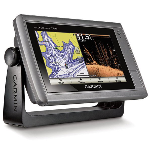
GARMIN echoMAP 73SV w/US LakeVu and Transom Mount Transducer CV40-TM


GPS 19x NMEA 2000 GPS Receiver


Panoptix PS60 Thru-hull Down Transducer

Panoptix PS21 LiveVu Forward Transducer

Panoptix PS21-TM Forward Transom Mount Transducer


NMEA 2000 Transducer Adapter Kit

GNT 10 NMEA 2000 - ANT Transceiver


GT41-TH Thru-Hull CHIRP DownVu, SideVu, Traditional Transducer with Temp 12-pin

GT41-THP Traditional 600W, 50/200kHz, ClearVu/SideVu CHIRP 260kHz, 455kHz Pair w/Fairing Block

GT50M-TH Thru-Hull CHIRP DownVu, SideVu, CHIRP Traditional Transducer with Temp 12-pin

GT50M-THP Pair Thru-Hull CHIRP DownVu, SideVu, CHIRP Traditional Transducer with Temp 12-pin


GT40-TM Transom CHIRP DownVu, SideVu, Traditional Transducer with Temp 12-pin


M260-8G 1kW 200/50kHz In-Hull Plastic Transducer


M265LH DO 42 210 kHz 1kW CHIRP In-hull/Pocket Plastic Transducer


R599LH 2-3kW CHIRP Transducer


B175L no connector 1kW 12 tilt CHIRP Bronze Transducer
B175H no connector 1kW 20 tilt CHIRP Bronze Transducer

P72-8G 500W 77/200 kHz Transducer


B175H 8pin 1kW 12 tilt CHIRP Transducer


B75H 0 deg tilt CHIRP Transducer


B75L 12 deg tilt CHIRP Transducer


Wide beam bare wires 0 Tilt 150-250 kHz 1kW CHIRP Bronze Transducer
Wide beam bare wires 12 Tilt 150-250 kHz 1kW CHIRP Bronze Transducer
Wide beam bare wires 20 Tilt 150-250 kHz 1kW CHIRP Bronze Transducer
B175H no connector 1kW 0 tilt CHIRP Bronze Transducer
B175H no connector 1kW 12 tilt CHIRP Bronze Transducer
B175L 8pin 1kW 0 tilt CHIRP Bronze Transducer
B175L no connector 1kW 20 tilt CHIRP Bronze Transducer
B175M no connector 1kW 0 tilt CHIRP Bronze Transducer
B175M no connector 1kW 12 tilt CHIRP Bronze Transducer
B175M no connector 1kW 20 tilt CHIRP Bronze Transducer

B265LH CHIRP Transducer

B45-DT-8G Thru-Hull 50/200 kHz Bronz Narrow Stem 8pin Transducer

CM599 LH 2-3kW CHIRP Transducer

CM599 LM 2-3kW CHIRP Pocket Mount Transducer


R109LH 38-210 kHz 2kW CHIRP Urethane Thru-Hull Transducer

R509LH DT 28-210 kHz 2-3kW CHIRP Epoxy Thru-Hull Transducer

R509LM DT 28-130 kHz 2-3kW CHIRP Epoxy Thru-Hull Transducer

SS164 0 deg tilt 1kW Transducer 8pin

SS164 12 deg tilt 1kW Transducer 8 pin

SS164 20 deg tilt 1kW Transducer 8 pin


TM150M 95-155 kHz Trunsom mount Plastic CHIRP 8pinTransducer

GT21-TM - Transom Mount DownVu 500W CHIRP 260/455 kHz Traditional 600W 50/200 kHz Transducer w/Temp


For Garmin Cone 19/6 1kW 50/200KHz 8pin Tank-Mount Transducer

For Garmin Beam 25 1kW 50/200KHz 8pin Tank-Mount Wide-Beam Transducer


For Garmin TM260 1kW DT 200/50kHz plastic Transom Mount 6 pin Transducer

TM265LH DT 42-210 Khz 1kW CHIRP Urth Transom Transducer


Airmar Smart Triducer, Plastic Thru, NMEA 2000


Contents of the package
- echoMAP unit
- Power/data cable
- Tilt/swivel mount
- Transom mount transducer cv40-TM
- Installation hardware
- Documentation
Features
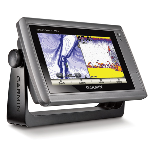
echoMAP 73SV w/US LakeVü HD & Transom Mount Transducer7" Combo with ClearVü and SideVü Scanning Sonar
- High-contrast color display with keypad control with preloaded Garmin LakeVü HD maps
- Built-in ClearVü and SideVü scanning sonar with the clearest images on the water
- Built-in 500 W (RMS) HD-ID sonar (4,000 W peak-to-peak)
- 5 Hz Internal GPS updates position and heading 5 times per second
- Tilting, quick-disconnect mount
echoMAP 73sv includes a 7-inch high-contrast color display with automatic backlight adjustment. Fast, responsive 5 Hz GPS/GLONASS refreshes your position and heading 5 times each second to make your movement on the screen more fluid. echoMAP comes with 1 transducer for 77/200 kHz HD-ID sonar and Garmin ClearVü/Garmin SideVü, the clearest scanning sonars on the water. It also supports Minn Kota® and MotorGuide® trolling motors with integrated transducers. The combo's cords plug directly into the mount, allowing you to quickly install and remove your device from power and the mount. Transom mount included.
Clearest Scanning Sonar on the Water
Garmin ClearVü scanning sonar gives you a nearly photographic image of what passes below your boat. Garmin SideVü scanning sonar gives you a crisp, clear view of what lies up to 750-feet off to each side of your boat. You clearly see structure, submerged objects and fish! Traditional Garmin HD-ID sonar and both ClearVü and SideVü scanning sonar are combined into one transducer. Also provides HD-ID support for Minn Kota and MotorGuide trolling motors with integrated transducers. The echoMAP 73sv also includes sonar-recording capability that coordinates the timing of the sonar return with your boat's position and saves digital information for playback on a computer using free HomePort planning software. Use the User Data Sharing Cable to share waypoints and routes between multiple devices.
Preloaded LakeVü HD Maps
These highly detailed freshwater maps include 17,000+ U.S. lakes, rivers and reservoirs (more than double the number of preloaded lakes of any competitor). That number also includes more than 6,700 HD lakes with 1-foot contours shoreline to shoreline (again, two times more than our competition). LakeVü HD gives you excellent detail of underwater features plus Safety Shading that allows you to designate a minimum depth; interstates, highways, general roads and bridges; designated fishing areas; and points of interest, such as docks, boat ramps, marinas and campgrounds.
Heading and Position Refreshed 5 Times per Second
Fast, responsive 5 Hz GPS/GLONASS refreshes your position and heading 5 times each second to make your movement on the screen more fluid. It makes dropping up to 5,000 accurate waypoints and finding your way back to your secret fishing hot spots quick and easy.
Take Your echoMAP with You
When youre off the water, its easy to keep your echoMAP safe and secure. You dont have to mess with plugging and unplugging wires from the unit because the cords plug directly into the mount. This allows you to quickly install and remove your echoMAP from power and the mount.
Upgrade with the Best Garmin Maps on the Water
A single microSD card slot provides expandable memory for accessory map purchases such as LakeVü HD Ultra or BlueChart® g2 or BlueChart g2 Vision. LakeVü HD Ultra adds high-resolution relief shading, Dynamic Lake Level, Depth Range Shading and more than 70 MaxDef lakes. LakeVü HD Ultra and BlueChart g2 Vision also provide exclusive Garmin Auto Guidance that directs you right to your hot spots by instantly creating an on-screen path based on your boats specifications that you can follow to avoid shallow water and other charted obstructions.
Enhanced Auto Guidance
Just enter the location where you want to go and patented Garmin Auto Guidance² technology instantly searches through relevant charts to create a virtual pathway on the display that helps you avoid low bridges, shallow water and other charted obstructions en route.
Better still, with enhanced Version 2.0, you now have access to even more features and capabilities. Youre able to adjust the calculated Auto Guidance pathway by inserting via points at interim stops or landmarks along your desired route. You can easily review hazard points along your calculated path. And you can even engage your compatible Garmin autopilot to follow the Auto Guidance route, automatically. Other 2.0 enhancements give you the ability to calculate arrival times at any point on your route (great for timing arrivals to correspond with bridge openings and other time-critical events). Better still, you can now save your plotted Auto Guidance paths for future navigation by backing them up on an SD card with your BlueChart® g2 Vision® or Garmin LakeVü HD Ultra cartography¹.
GPX Waypoints Transfer
If you have waypoints, tracks or frequently used routes stored on another manufacturers GPS product or on a Garmin handheld device now its easier than ever to transfer those items to your new Garmin chartplotter, via industry-standard GPX software formatting. GPX is an open standard format for GPS data exchange across platforms and applications. With this easy-to-use interface technology, Garmin has taken no waypoint left behind to a whole new level of trade-up convenience.
Create your own HD maps
Quickdraw Contours is a free, easy-to-use software feature that is already installed on your compatible Garmin device. It instantly creates your very own personalized HD fishing maps with 1-foot contours. Tailor them to fit your needs. They are your maps. You own them. Keep the data to yourself or share it with Garmin or your friends. Theres no special surveying expertise required. You just fish while it creates maps. You dont have to wait around or send your files away like other mapping software requires your results appear instantly. Use with any Garmin Panoptix, any HD-ID, any CHIRP-enabled, Garmin ClearVü transducer or NMEA 2000®-compatible depth transducer. Have more than 1 sonar device installed onboard? Quickdraw Contours automatically selects the most capable sonar device to provide the very best results for you!
Multiple Depth Range Shading
Designate up to 10 different depth ranges each with its own color. Makes it easier to view target depths at a glance.
Specifications
| Display | 7" diag. color LCD |
|---|---|
| Resolution | 480 x 800 pixels |
| Antenna | Internal, 5Hz |
| Power | 500 Watts RMS |
| Frequency | 50/77/200 KHz traditional sonar, 455/800KHz Down/SideVu sonar |
| Transducer | Includes CV40 transom mount transducer |
| Mapping | Pre-loaded LakeVu US Charts. Ability to add additional maps via micro-SD card slots. |
| Waypoints/Routes | 5,000 waypoints; 100 routes; 50,000 trackpoints; 50 saved tracks |
| Interface | NMEA 0183 in/out |
| Other Functions | Optional AIS, Quickdraw Contours custom maps, Auto Guidance, GPX waypoint transfer, optional Panoptix scanning sonar. |
| Dimensions | 9.8"W x 5.5"H x 2"D; Wt: 1.7 lb. |
| Warranty | One Year |
Item number: 010-01795-01
UPC: 753759175757
Package weight: 8 lb
Following reviews were written by actual customers.
Every GPS4US customer has a chance to live a feedback after receiving a product.
 by christopher N, , 8/25/2018
Smoking hot deal for a brand new unit......easy install with everything I wanted
by Aleksandr K, , 6/25/2018Спасибо огромное вашему магазину! Очень понравилось общение с вашим сотрудником! Отвечал очень быстро и главное по русски) быстро отправили покупку и отличный товар. Еще раз спасибо, буду рекомендовать вас!
Other Products in the Series: