LOWRANCE Elite-12 TI2, US Inland, No Transducer
Item: 000-14653-001
This item is brand new
$1,269.95
This item ships within 1 day
|cw|sw|wi|ss


Suggested Maps and Software:
 | Navionics Marine Charts
Navionics charts are now a fundamental tool of navigation, featuring water depths, navaids, obstructions, and other information necessary for safe navigation. Marine and lake maps presented. |
 | Lowrance Maps
TOPO Insight HD maps are used with all-terrain vehicles, snowmobiles, etc., for off-road navigation. Nautic insight NEW! Improved Bathymetric Contour Detail with greater coverage and more accurate detail to navigate more safely and identify key fishing areas.
|
 | C-Map Charts
C-MAP serves boaters worldwide, providing cartography products and
services for all types of leisure boaters, from fishermen and sailing
enthusiasts to powerboat owners.
|
 | Cmor maps
CMOR Mapping data is the result of methodical surveys with
high-resolution echosounders. There is no interpolation, no guesswork,
and no unverified "hotspots" reported by local captains. All you see is a
complete, accurate, and highly detailed representation of the bottom,
including many features that are not shown on any other chart or fishing
map |
Contents of the package
Features
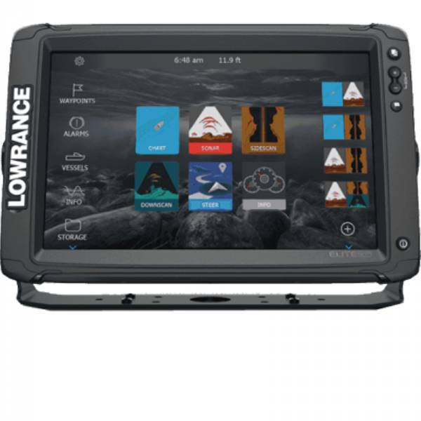
Elite-12 TI2, MFG# 000-14653-001, combo plotter/sounder with 12 in LCD, internal GPS/Chartplotter with US Inland maps, Active Imaging 3-in-1 sonar (CHIRP/SideScan/DownScan), Bluetooth and WiFi. Transducer not included.
Specifications
Item number: 000-14653-001
UPC: 9420024175408
Package weight: 14.30 lb