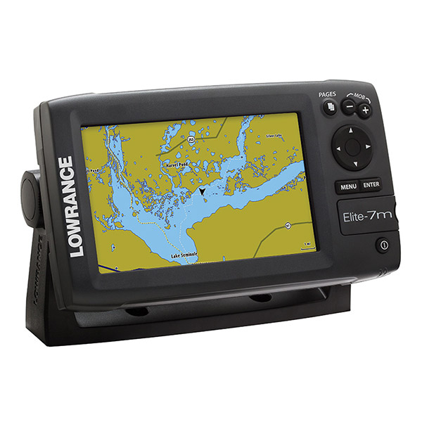
LOWRANCE Elite-7 Broadband Combo
This item is brand new
$599.95
This item ships within 8 days


Point-1 GPS Antenna


LMF-200 Compact Multi - Function Gauge w/out Sensor

LMF-400 Multi - Function Gauge w/out Sensor


Temperature Sensor

Speed and Temp Probe

P79-BL 50 200 Khz Plastic In-Hull Transducer Blue


PD-WSU 20 Cone 200 Khz Transducer


Suggested Maps and Software:
 | Navionics Marine Charts |
 | Lowrance Maps |
 | C-Map Charts |
 | Cmor maps |
Contents of the package
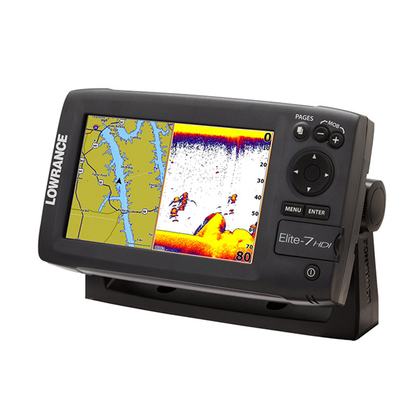
Features
- 70% larger Elite color display
- Multi-Window displays lets you choose up to threepanels in split-screen mode to view chart, sonar and DownScan Imaging -- all on one screen
- Reliable navigation thats easy-to-use
- Exclusive technology overlays DownScan Imaging onto Broadband Sounder display for one stunning view
- TrackBack through sonar history Hybrid Dual Imaging (HDI) ready Supported by Lowrance Advantage Service
Specifications
OverviewDisplay 7" / 178mm Widescreen 16:9
Resolution 800 x 480
Backlighting LED
Power Output: RMS (PTP) Max 250W RMS, 30,000W Peak to Peak analog equivalent
Operating Frequency (50/200 kHz or 83/200 kHz) + 455/800 kHz
Waypoint Management 3000
Languages 31
Operating Voltage 12 vDC (10-17 vDC min-max)
Warranty One Year
Display
Display Resolution 800 x 480
Display Type 16-bit color, Full VGA SolarMax PlusTFT
Display: Backlighting LED
Backlighting Levels Adjustable Screen
Display Size 7 inches / 178 mm
Technical
Housing Plastic
Sonar
Depth Alarm Yes
EchoSounder Frequencies (50/200 or 83/200 kHz) + 455/800 kHz
Shallow Alarm Yes
Temperature Readings Yes
Transducer Type Multiple selections Lowrance and Airmar®
Max Depth per Type
DownScan Imaging: Max 300 ft / 91 m @ 455/800 KHz
Broadband Sounder: Max 1000 ft / 305 m @ 83/200 kHz
Broadband Sounder: Max 2500 ft / 762 m @ 50/200 kHz
Technical/Environmental
Waterproof Standard/rating IPx7
Product Width 9.26 inches
Product Depth 3.0 inches
Product Height 5.3 inches
Power
Power Supply (Supply Voltage) 12 vDC (10-17 vDC min-max)
GPS Navigation
Navigation: Routes 100
Navigation: Waypoint Storage 3000
GPS Antenna Type Internal high-sensitivity GPS+WAAS
Plot Trails Up to 100 trails - up to 10,000 points / trail
Background Mapping Worldwide background map
Networking Connectors
NMEA Output NMEA 2000, NMEA 0183
Other
Languages 31
Output Power kW 12 W (0.9 A @ 13 vDC)
Item number: 000-10968-001
UPC: 9420024121719
Package weight: 7 lb