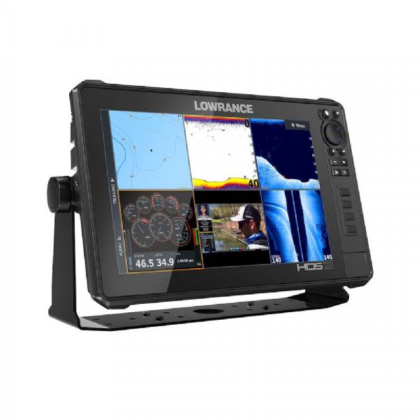
LOWRANCE HDS-12 Live MFD, w/ AI 3-In-1 Transducer
This item is brand new
$1,779.00
Request price match
This item ships within 1 day
st|cw|sw|wi|ss|ln


Xsonic ss60 12 deg tilted element thru hull - 9-pin connector - 10m cable


Xsonic ss75m stainless steel thru-hull medium chirp transducer - 12 deg element - 9-pin


XSONIC SS75M Depth/Temperature Transducer 0deg - 9-Pin - 600W - 10M Cable

XSONIC SS75H Depth/Temperature Transducer 20deg - 9-Pin - 600W - 10M Cable


XSONIC SS75H Depth/Temperature Transducer 0deg - 9-Pin - 600W - 10M Cable


LiveScope Transducer


Camera w/Infra Red f/Low Light Conditions


Suggested Maps and Software:
 | Navionics Marine Charts |
C-Map MAX-N+ | |
C-Map MAX-N | |
 | Cmor maps |
Contents of the package
Features
Lowrance HDS-12 Live MFDModel: 00014428001
Active Imaging 3-in-1 (CHIRP/SideScan/DownScan)
LiveSight real-time sonar compatible
Smartphone notifications
C-MAP Genesis Live onscreen mapping
StructureScan® 3D with Active Imaging enhancements
High-performance quad-core processor
FishReveal Smart Target View
Full high-definition HDS SolarMAX HD multi-touch screen with the widest range of viewing angles viewable even through polarized sunglasses
Preloaded high-detail C-MAP® US Enhanced charts with 1-foot contours on 4,000-plus lakes
C-MAP Easy Routing, Navionics Autorouting capability
Dual-Channel CHIRP dual sonar-range coverage from the same transducer
Live Network Sonar cover more water and mark fish targets more clearly from a network of CHIRP sonar transducers
Wireless and Bluetooth® connectivity
Heat Map feature allows anglers to see trends in water temperature changes to quickly target key fishing areas
Enhanced Surface Clarity lets you see more fish targets near the surface
Quick Access Control Bar provides onetouch access to system controls
Built-in CHIRP and Broadband Sounder
SmartSteer control for Xi5 Trolling Motor and Outboard Pilot
Radar and SonicHub®2 audio server connectivity
Radar and SonicHub®2 audio server connectivity
Optional mapping upgrades include C-MAP, Navionics® and more
The Lowrance HDS-12 LIVE with Active Imaging 3-1 Transducer offers the best collection of innovative sonar features available, including Active Imaging, StructureScan® 3D with Active Imaging, FishReveal and LiveSight sonar plus exciting functionality like C-MAP® Genesis Live mapping and LiveCast smartphone integration.
Full high-definition SolarMAX HD multi-touch screen - Preloaded C-MAP® US Enhanced mapping. Compatible with Active Imaging, StructureScan® 3D with Active Imaging and LiveSight real-time sonar. Includes wireless connectivity, Ethernet, NMEA 2000®, LiveCast smartphone Integration + ultimate integration capability. Includes Active Imaging 3-in-1 Transducer. Year after year, more fishing tour pros use HDS than all other fishfinder brands combined. HDS LIVE is poised to carry on that tradition behind premium performance and the best collection of innovative sonar features available from new Active Imaging and StructureScan® 3D with Active Imaging to FishReveal and LiveSight real-time sonar you will experience a new level of fishfinding performance with HDS LIVE. Navigating to your favorite fishing spot or finding a new one has never been easier, behind the best suite of navigation features ever built into the HDS Live display -- including preloaded C-MAP® US Enhanced mapping with 1-foot contours on 4,000-plus lakes, C-MAP® Easy Routing, Navionics® Autorouting and C-MAP Genesis Live mapping. HDS LIVE also simplifies your time on the water with onscreen text messages and call notifications, as well as LiveCast smartphone connection, which allows you to display video, Google Maps and fishing data on your fishfinder display.
Specifications
Resolution 1280 x 800Brightness > 1200 nits
Type 12" IPS
Touch Screen Multi-Touch
Viewing Angle 80° top/bottom, 80° left/right
Supply Voltage 12 V DC (10 - 17 V DC min - max)
Power Consumption - MAX 49.68 W (3.6A at 13.8 V DC)
Recommended Fuse 5 A
Operating Temp Range -15°C to +55°C (5°F to 131°F)
Storage Temp Range -20°C to +60°C (4°F to 140°F)
Waterproof Rating IPX6 and IPX7
NMEA 2000 1 port (Micro-C)
NMEA 0183 1 port (In Power Cable)
Ethernet 2 ports
2 ports 1 port
Analog Video In 1 port (optional cable)
USB 1 port (USB-A 5V DC, 1.5A)
Card Slots 2 slots microSD
Wireless Built-in 802.11 b/g/n
Bluetooth Bluetooth 4.0 with support for Bluetooth Classic
Item number: 000-14428-001
UPC: 9420024171950
Package weight: 15.70 lb