LOWRANCE HDS 7 Gen2 Insight USA 83/200 kHz TM Transducer


This item is brand new
$899.00
This item ships within 3 days


LGC 4000 GPS Receiver Antenna

Point-1 GPS Antenna

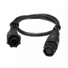
15 inh Transducer Extension Cable


Protective Cover (replacement)


Suncover, HDS-7 GEN2 Touch


LMF-200 Compact Multi - Function Gauge w/out Sensor
LMF-400 Multi - Function Gauge w/out Sensor


Outboard Pilot Hydraulic Pack


LSS 1 StructureScan Sounder with Transducer

NEP 1 Navico Expansion Port 1
Temperature Sensor
Speed and Temp Probe

LSS-2 StructureScan HD w/TM Transducer f/Lowrance and Simrad


Navico LSS-2 StructureScan HD w/o Transducer f/and Simrad
P79-BL 50 200 Khz Plastic In-Hull Transducer Blue


StructureScan HD Bronze Thru-Hull Single

StructureScan HD Bronze Thru-Hull Transducer - Pair

Structure Scan HD Bronze Thru-Hull, Port


B164 12 Tilt Transducer 50 200 Khz bronze 6 pin thru-hull
B258-BL 50 200 kHz Bronze Thru Hull 7pin Transducer Blue

HS-WSBL 20 Cone 200 Khz Transducer Skimmer


M260-BL 50 200 kHz Plastic1 kW In Hull w/Tank Kit 7pin Blue


SonicHub Marine Audio Server with MP3 Dock and 2 Speakers

SonicHub Marine Audio Server Pack
Suggested Maps and Software:
 | Navionics Marine Charts |
 | Lowrance Maps Topo |
 | Lowrance Maps Nautic Lake |
C-Map MAX-N+ | |
C-Map MAX-N | |
 | Cmor maps |
Contents of the package
Features
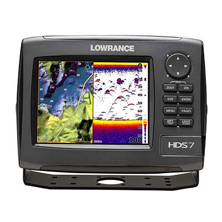
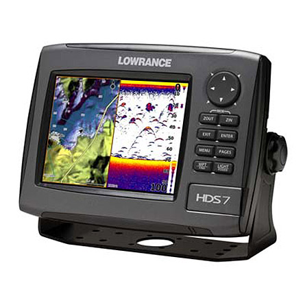
The 6.4 in/16.3 cm display with LED backlight provides an easy-to-view, two-panel splitscreen for example, with chart and Broadband Sounder all at a more affordable price. Plus, HDS-7 offers the added option of a three-window view.
Available in a variety of transducer-pack options:
- 83/200 kHz for inland/freshwater uses.
- 50/200 kHz for deeper Great Lakes/coastal saltwater uses
- Also compatible with Airmar® in-hull or thru-hull transducers for up to 1 kW operation for deeper, saltwater applications
One waterproof SD card slot to load high-detail charting options. Users can also and save sonar and navigational data, and upload future HDS® software feature updates.
HDS built-in cartography options:
- Americas*: Enhanced U.S. basemap, or intuitive, life-like Insight USA mapping.
- Worldwide (non-Americas): Navionics® world background map
All HDS models are fully compatible with third party mapping
solutions including Insight HD and Fishing Hot Spots® PRO, as well as
Navionics® Gold, Platinum and Platinum+ with TurboView® for the best
possible chartplotter experience.
New, fastest HDS® ever
Realtime StructureMap capability
Super-accurate, internal GPS antenna
High-bright, sunlight-viewable display with LED backlighting.
TrackBack feature to review sonar history and save waypoints on key locations.
Built-in Insight USA mapping options (Americas models) or Navionics® world background map.
High-detail mapping options including Insight HD, Navionics® Platinum+ with TurboVIew, and Fishing Hot Spots® PRO
NMEA 2000® and high-speed Ethernet networking options
Two-year limited warranty
Specifications
DISPLAY
| Display Size | 6.4 in \ 163 mm |
| Display Resolution | 480 x 640 (H x W) |
| Display Type | 16-bit color Full VGA SolarMAX PLUS TFT |
| Backlighting | Screen/Keypad |
| Backlighting Type | Pure white LED |
| Sonar And GPS Overlay Data | Yes |
| Split Screen Presentation | Yes |
| Multilanguage Display | Yes |
| Languages Supported | 32 |
SONAR / SOUNDER
| Sonar Frequency | 50/83/200 kHz |
| Transducer Type | Multiple selections for Lowrance® and Airmar® |
| Sonar Output Power | Max 250W Broadband, analog equivalent 30,000W and 32W Broadband, analog equivalent 3,750 W |
| Sonar Depth | Max 5000 ft \ 1524 m |
| Standard Fishfinder Features: COLORLINE/GRAYLINE®, ASP, FishSymbol I.D., FishTrack, and more | Yes |
| FasTrack | Yes |
| Ping Speed HyperScroll | Yes |
| Depth Alarm | Yes |
| Shallow Alarm | Yes |
| Temperature Display | Yes |
GPS / NAVIGATION
| GPS Antenna Type | Internal, high-sensitivity GPS+WAAS (Americas) or GPS+EGNOS+MSAS (non-Americas) |
| Background Map | Expanded U.S. BaseMap or Insight USA (Americas) or Worldwide background map (non-Americas) |
| Custom Mapping | Optional Lowrance Lake Insight HD, Lake Insight PRO, Nautic Insight HD, Nautic Insight PRO, Navionics Platinum+ and Platinum chartcards with Turboview for worldwide coverage - as well as Navionics® HotMaps Platinum, Fishing Hot Spots® PRO and legacy LakeMaster® Promaps |
| Waypoint Storage | 5000 |
| Routes | 200 |
| Plot Trails | Up to 10 trails - up to 12,000 points/trail |
| Man Overboard Feature | Yes |
| GPS Alarms | Yes |
RADAR
| Antenna Type | Optional Lowrance radar choices available |
NETWORKING / CONNECTORS
| NMEA 0183 Input | Yes |
| NMEA 0183 Interface | Type 422 {(1) Tx (1) Rx} |
| NMEA 2000 Certified | Yes |
| NMEA Output | 0183/2000 |
| Connectors | NMEA 2000®, NMEA 0183 and Ethernet |
TECHNICAL / ENVIRONMENTAL
| Built-in Backup Memory | Yes |
| Casing | Sealed and waterproof IPX7 |
| Width | 8.8 in \ 223 mm |
| Height | 6.5 in \ 164 mm |
| Depth | 3.5 in \ 88 mm |
| Operating Temperature | (5F - 130F) (-15C - 55C) |
POWER
| Power Supply | 10 - 17 vDC |
| Power Consumption | 0.7A at 13 vDC with backlight on, 0.4A with backlight off |
| NMEA 2000 Load Equivalency Number | 1 network load (50mA) |
OTHER
| Memory Card Capable | One SD/MMC memory card slot |
| Operating Temperature Stored | (-40F - 185F) (-40C - 85C) |
| Other Features |
Performance Modules: StructureScan with optional LSS-1 module (8 color palette options), Broadband Sounder technology (with 14 color palette options), ethernet networking, optional SIRIUS Satellite Weather/Radio, Broadband Radar, Digital Radar, SonicHub, AIS, DSC VHF new 2-year limited warranty |
Item number: 000-10530-001
UPC: 9420024113240
Package weight: 8 lb
Other Products in the Series: