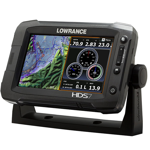
LOWRANCE HDS 7 Gen2 Touch Insight USA Multifunction (transducer solid separetely


This item is brand new
$1,149.95
This item ships within 2 days


LGC 4000 GPS Receiver Antenna

Point-1 GPS Antenna

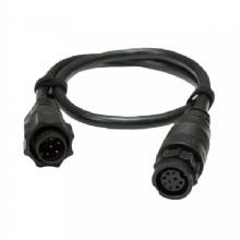
15 inh Transducer Extension Cable


LMF-200 Compact Multi - Function Gauge w/out Sensor
LMF-400 Multi - Function Gauge w/out Sensor


Outboard Pilot Hydraulic Pack


LSS 1 StructureScan Sounder with Transducer

NEP 1 Navico Expansion Port 1
3G Broadband Radar Dome w/10M Cable
4G Broadband Radar w/10M Cable
Temperature Sensor
Speed and Temp Probe

LSS-2 StructureScan HD w/TM Transducer f/Lowrance and Simrad


Navico LSS-2 StructureScan HD w/o Transducer f/and Simrad
P79-BL 50 200 Khz Plastic In-Hull Transducer Blue


StructureScan HD Bronze Thru-Hull Single

StructureScan HD Bronze Thru-Hull Transducer - Pair

Structure Scan HD Bronze Thru-Hull, Port


B164 12 Tilt Transducer 50 200 Khz bronze 6 pin thru-hull
B258-BL 50 200 kHz Bronze Thru Hull 7pin Transducer Blue

HS-WSBL 20 Cone 200 Khz Transducer Skimmer


M260-BL 50 200 kHz Plastic1 kW In Hull w/Tank Kit 7pin Blue


SonicHub Marine Audio Server with MP3 Dock and 2 Speakers

SonicHub Marine Audio Server Pack
Suggested Maps and Software:
 | Navionics Marine Charts |
 | Lowrance Maps Topo |
 | Lowrance Maps Nautic Lake |
C-Map MAX-N+ | |
C-Map MAX-N | |
 | Cmor maps |
Contents of the package
Features
OverviewDisplay Widescreen, 16:9 ; WVGA color TFT LCD
Resolution 800 x 480
Power Output: RMS (PTP) Max 250W RMS, 30,000W Peak to Peak analog equivalent
Operating Frequency (50/200 or 83/200 kHz) + 455/800 kHz
Languages 36
Media Port 1 SD (full size)
Warranty Two Year
Display
Display Resolution 800 x 480
Display Type WVGA color TFT LCD
GPS and Sonar Overlay Data Yes
Split Screen Presentation 4
Display Size 7"/ 178 mm
Brightness 1250 nits
Sonar
Depth Alarm Yes
Shallow Alarm Yes
Standard Fishfinding Features: COLORLINE or GRAYLINE®, ASP, FishSymbol I.D., FishTrack, and more Yes
Temperature Readings Yes
Transducer Type Multiple Selections Lowrance and Airmar
Technical/Environmental
Operating Temperature -15° C to + 55° C (+ 5° F to + 131° F)
Product Width 8.44"
Product Depth 3.24"
Product Height 5.76"
Power
Power Consumption 12 W (0.9 A @ 13 V DC)
Power Supply (Supply Voltage) 12 V DC (10.8 - 17.0 V DC min - max) 31
GPS Navigation
Navigation: Routes 200
Navigation: Waypoint Storage 5000
GPS Alarms Yes
Background Mapping Built in Insight USA (Americas) or Worldwide background map (non-Americas)
Other
Languages 36 total, available on 5 Language Packs
Specifications
OverviewDisplay Widescreen, 16:9 ; WVGA color TFT LCD
Resolution 800 x 480
Power Output: RMS (PTP) Max 250W RMS, 30,000W Peak to Peak analog equivalent
Operating Frequency (50/200 or 83/200 kHz) + 455/800 kHz
Languages 36
Media Port 1 SD (full size)
Warranty Two Year
Display
Display Resolution 800 x 480
Display Type WVGA color TFT LCD
GPS and Sonar Overlay Data Yes
Split Screen Presentation 4
Display Size 7"/ 178 mm
Brightness 1250 nits
Sonar
Depth Alarm Yes
Shallow Alarm Yes
Standard Fishfinding Features: COLORLINE or GRAYLINE®, ASP, FishSymbol I.D., FishTrack, and more Yes
Temperature Readings Yes
Transducer Type Multiple Selections Lowrance and Airmar
Technical/Environmental
Operating Temperature -15° C to + 55° C (+ 5° F to + 131° F)
Product Width 8.44"
Product Depth 3.24"
Product Height 5.76"
Power
Power Consumption 12 W (0.9 A @ 13 V DC)
Power Supply (Supply Voltage) 12 V DC (10.8 - 17.0 V DC min - max) 31
GPS Navigation
Navigation: Routes 200
Navigation: Waypoint Storage 5000
GPS Alarms Yes
Background Mapping Built in Insight USA (Americas) or Worldwide background map (non-Americas)
Other
Languages 36 total, available on 5 Language Packs
Item number: 000-10764-001
UPC: 9420024118443
Package weight: 8 lb
Other Products in the Series: