LOWRANCE HDS-9 GEN2 Touch Insight w/83/200
This item is brand new
$1,299.95
This item ships within 2 days


LGC 4000 GPS Receiver Antenna

Point-1 GPS Antenna


15 inh Transducer Extension Cable


LMF-200 Compact Multi - Function Gauge w/out Sensor

LMF-400 Multi - Function Gauge w/out Sensor


Outboard Pilot Hydraulic Pack


Dome Camera, Surface Mount,Rev. Image

LSS 1 StructureScan Sounder with Transducer

NEP 1 Navico Expansion Port 1

Temperature Sensor

Speed and Temp Probe

LSS-2 StructureScan HD w/TM Transducer f/Lowrance and Simrad


Navico LSS-2 StructureScan HD w/o Transducer f/Lowrance and Simrad

P79-BL 50 200 Khz Plastic In-Hull Transducer Blue


StructureScan HD Bronze Thru-Hull Single

StructureScan HD Bronze Thru-Hull Transducer - Pair

Structure Scan HD Bronze Thru-Hull, Port


B164 12 Tilt Transducer 50 200 Khz bronze 6 pin thru-hull

B258-BL 50 200 kHz Bronze Thru Hull 7pin Transducer Blue


HS-WSBL 20 Cone 200 Khz Transducer Skimmer


M260-BL 50 200 kHz Plastic1 kW In Hull w/Tank Kit 7pin Blue


SonicHub Marine Audio Server with MP3 Dock and 2 Speakers

SonicHub Marine Audio Server Pack
Suggested Maps and Software:
 | Navionics Marine Charts |
 | Lowrance Maps Topo |
 | Lowrance Maps Nautic Lake |
C-Map MAX-N+ | |
C-Map MAX-N | |
 | Cmor maps |
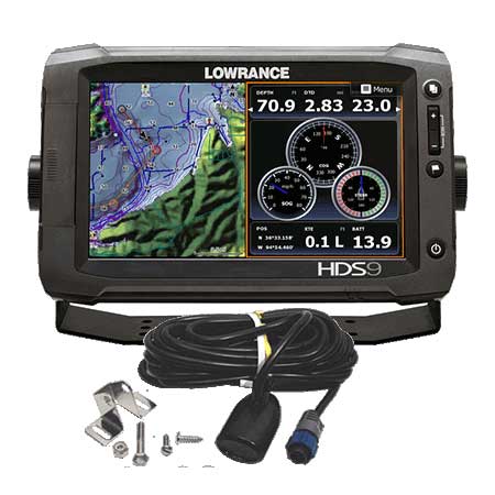
Contents of the package
Mounting bracket
Sun cover
Power cable
Installation hardware
Owner's manual and Quick Start guide
83/200KHz transom mount transducer
Features
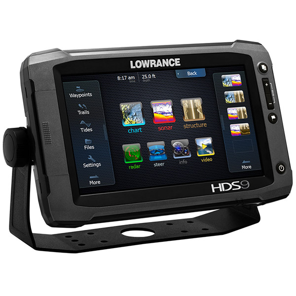
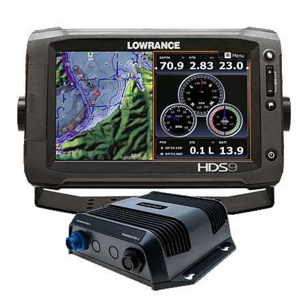
HDS-9 Gen2 Touchscreen Chartplotter/Fishfinder w/83/200KHz Transducer9" Widescreen LCD, Insight USA (Coastal & Inland) Charts
The new, Generation 2 Touch series of multi-function displays are a revolutionary step forward in fishfinding and navigation-electronics innovation. Featuring lightning-fast chart redraw, they combine the legendary, best-in-class Lowrance technology, fully integrated weather and radar solutions and an attractive case design that is more convenient to install. Plus, a new easier-to-use operating system simplifies access to frequently used (and more advanced) features, to enhance your boating pleasure and fishing success. For building an onboard system, HDS provides a truly advanced definition in multi-tasking compatibilities.
Personalized or built-in Insight mapping and optional Navionics® charts. View both at once in 3D perspective view, plus StructureMap, Broadband Radar and SIRIUS® weather overlay capability. A super-accurate, internal GPS receiver comes standard on all HDS Gen2 Touch models, plus built-in Insight USA high-definition mapping with contour shading. 3D perspective view is also now available with both Insight USA maps and optional Navionics charts, plus a dual-view option allows you to simultaneously use two maps at once.
Built-in StructureScan HD sonar imaging, plus award-winning Broadband Sounder with DownScan Overlay and TrackBack feature. The ultimate fish- and structure-finding display. Dedicated StructureScan HD signals for left-, right- and down-looking images, plus award-winning Broadband Sounder. Real-time StructureMap capability allows you to overlay StructureScan Sonar Imaging data onto your favorite chart for a life-like underwater view with greater perspective of your boat's position to nearby structure. Overlay DownScan Imaging onto your BroadBand Sounder view for the ultimate fish-and structure-finding display.
Powerful touchscreen with redesigned menus and five push-button controls simplify operation without sacrificing features.
Make your own map! Create high-definition contours, bottom hardness, and more from personalized sonar log recordings on a powerful, new Lowrance web-based map creation tool.
Standard on all HDS® Gen2 Touch models, network and share data across all HDS displays for the ultimate flexibility and cost-savings. NMEA 2000®, NMEA 0183 and Ethernet-compatible with up to two Ethernet ports.
Compatible with Broadband 4G and 3G Radar, SIRIUS® satellite radio and weather receiver, LGC-4000 external GPS antenna, SonicHub marine audio server, AIS collision-avoidance system, engine interface cables, plus video camera inputs on 9- and 12-inch models.
Up to two waterproof SD card slots to load Insight HD, Navionics® map options, Fishing HotSpots PRO®, backup waypoints, routes, trails and settings, and create personalized Insight Genesis maps and StructureMap from recorded sonar log recordings.
GoFree WiFi-1 module compatible via Ethernet, when combined with a GoFree Wireless app provides remote viewing and control of HDS Gen2 Touch on the iPhone, iPad and Android devices.
Supported by 5-Year Lowrance Advantage and two-year limited warranty.
Specifications
Display 9" diag. 16:9 touchscreen color LCDResolution 800x 480 pixels; VGA
Antenna Internal; external option
Mapping Preloaded w/ Insight USA w/ contour shading. Optional Insight HD or Navionics Platinum on SD
card (2 slots).
Waypoints/Routes 5,000 waypoints; 200 routes; 12,000 trackpoints
Sounder Built-in 50/83/200KHz conventinal sounder and 455/800KHz StructureScan sonar. Includes
83/200KHz transom mount transducer.
Radar Available radar antennas include 2KW or 4KW radomes, 6KW open array, as well as a 165mW,
19" FMCW broadband radome
Interface Ethernet (2 ports); NMEA 2000; NMEA 0183
Other Functions Options: Video input, Sonic Hub, Sirius WX/Audio, AIS, engine/fuel montoring, WiFi connectivity
(2013)
Dimensions 10.43"W x 6.65"H x 3.32"D
Warranty Two Year
Item number: HDS-9 PROMO 2
UPC: -
Package weight: 8.5 lb
Other Products in the Series: