LOWRANCE HDS 9 Gen2 Touch with CMAP Max-N (Latin America ONLY)


This item is brand new
$3,267.95
This item ships within 8 days


LGC 4000 GPS Receiver Antenna

Point-1 GPS Antenna


15 inh Transducer Extension Cable


LMF-200 Compact Multi - Function Gauge w/out Sensor

LMF-400 Multi - Function Gauge w/out Sensor


Outboard Pilot Hydraulic Pack


Dome Camera, Surface Mount,Rev. Image

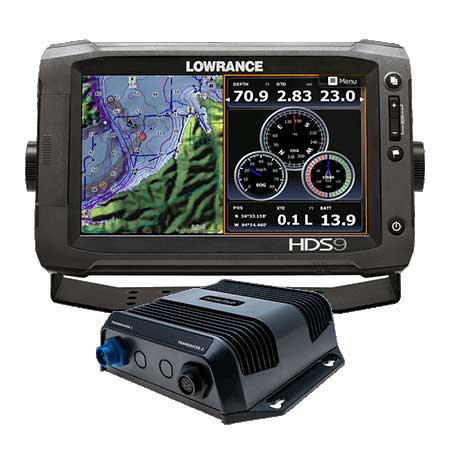
LSS 1 StructureScan Sounder with Transducer

NEP 1 Navico Expansion Port 1

3G Broadband Radar Dome w/10M Cable

4G Broadband Radar w/10M Cable

Temperature Sensor

Speed and Temp Probe

LSS-2 StructureScan HD w/TM Transducer f/Lowrance and Simrad


Navico LSS-2 StructureScan HD w/o Transducer f/Lowrance and Simrad

P79-BL 50 200 Khz Plastic In-Hull Transducer Blue


StructureScan HD Bronze Thru-Hull Single

StructureScan HD Bronze Thru-Hull Transducer - Pair

Structure Scan HD Bronze Thru-Hull, Port


B164 12 Tilt Transducer 50 200 Khz bronze 6 pin thru-hull

B258-BL 50 200 kHz Bronze Thru Hull 7pin Transducer Blue


HS-WSBL 20 Cone 200 Khz Transducer Skimmer


M260-BL 50 200 kHz Plastic1 kW In Hull w/Tank Kit 7pin Blue


SonicHub Marine Audio Server with MP3 Dock and 2 Speakers

SonicHub Marine Audio Server Pack
Suggested Maps and Software:
 | Navionics Marine Charts |
 | Lowrance Maps Topo |
 | Lowrance Maps Nautic Lake |
C-Map MAX-N+ | |
C-Map MAX-N | |
 | Cmor maps |
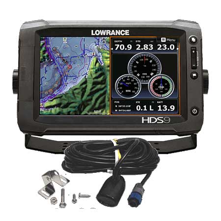
Contents of the package
Features
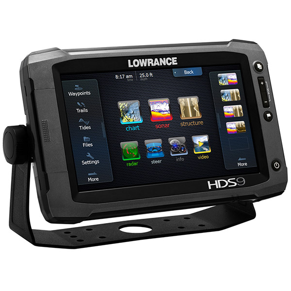
- Easy to use touchscreen Revolutionary new user interface provides lightning-fast, fingertip access to all HDS features. Intuitive menus, cursor assist, snap-to setting markers and innovative preview panes with quick-touch slider bars provide unparalleled control in all weather and water conditions.
- Built-in StructureScan® HD sonar imaging - Enjoy picture-like, 180-degree views of structure and fish below your boat. Plus, overlay live high-definition bottom imagery on top of your charts using the innovative StructureMap feature. Requires optional StructureScan® HD transducer.
- Built-in, award-winning Broadband Sounder - Display and mark gamefish, baitfish and structure at higher speeds and at greater depths from 1 to 3,000 feet.
- New, StructureMap HD capability Use recorded StructureScan® HD logs to create stunning underwater images of lakes, rivers or seafloor. StructureMap can be viewed as an overlay, and toggled on and off to provide the ultimate in situational awareness in relation to both chart and bottom detail.
- Super-accurate, internal 5Hz GPS antenna - 5Hz position update rate provides more accurate trails and smoother chart performance for the maximum in reliable position accuracy. Supports WAAS/EGNOS/MSAS corrections. For even greater performance and functionality, add an external Lowrance Point-1 10Hz GPS antenna with built in compass.
- TrackBack to review and save key hotspots - Scroll-back thru Broadband Sounder or StructureScan® HD sonar imaging history to review structure or fish targets and pinpoint the location with a waypoint.
- GoFree Wireless ready View and control select fishfinder and chartplotter displays wirelessly using supported tablets and smartphones and the free GoFree app. Requires the revolutionary WIFI-1 module.
- Extensive mapping options HDS Gen2 Touch includes built-in charts or bundled map options, and is compatible with the most expansive selection of cartography on the market. Options include Insight HD, Insight PRO, Insight Genesis, Navionics®, C-Map Max-N, TOPO, and more. All charting options can be used with Insight Planner PC planning software. Visit the Insight Store for more details.
- Multi-view and chart sharing View Navionics® cartography simultaneously with the charts of your choice, in 2D or 3D perspective view, with independent control, range and overlay capabilities. Plus, get the maximum from your chart card purchases; buy one map card and view it on all networked HDS Gen2 or Gen2 Touch chartplotter displays.
- Depth contour shading and shallow water highlight - Use these new features with Navionics Charts to quickly identify fishing areas of interest or to highlight shallow water areas requiring extra caution.
- New, Insight Genesis personalized maps Make your own maps using recorded sonar logs, upload data to Insight Genesis account, view secure custom chart detail online, adjust contour lines, add optional vegetation or bottom-hardness overlays, download to an SD card and use on the water.
- Optional video-camera input (video camera input cable sold separately). Brilliant, enhanced SolarMAX PLUS display for superior sunlight and wider-angle viewing. Affordable NMEA 2000® and high-speed dual Ethernet ports. Two full-sized SD card slots.
Specifications
OverviewDisplay Widescreen, 16:9 ; WVGA color TFT LCD
Resolution 800 x 480
Operating Frequency (50/200 or 83/ 200 kHz) + 455/800 kHz
Languages 36 total, available on 5 language packs
Media Port 2 SD (full size)
Warranty Two Year
Display
Display Resolution 800 x 480
Display Type WVGA color TFT LCD
Display Size 9" / 228 mm
Brightness 1400 nits
Sonar
Depth Alarm Yes
Shallow Alarm Yes
Standard Fishfinding Features: COLORLINE or GRAYLINE®, ASP, FishSymbol I.D., FishTrack, and more Yes
Technical/Environmental
Operating Temperature -15° C to + 55° C (+5° F to + 131°F)
Weight kg 2
Product Width 10.43
Product Depth 3.32
Product Height 6.65
Power
Power Consumption 15.6 W (1.2 A @ 13 V DC)
Power Supply (Supply Voltage) 12 V DC (10.8 - 17.0 V DC min - max)
GPS Navigation
Navigation: Routes 200
Navigation: Waypoint Storage 5000
GPS Antenna Type Internal, high-sensitivity GPS+WAAS (Americas) or GPS+EGNOS+MSAS (non-Americas)
Background Mapping Built-in Insight USA (Americas) or Worldwide background map (non-Americas)
Other
Languages 36 available on 5 language packs
Item number: 000-10769-003
UPC: -
Package weight: 11 lb
Other Products in the Series: