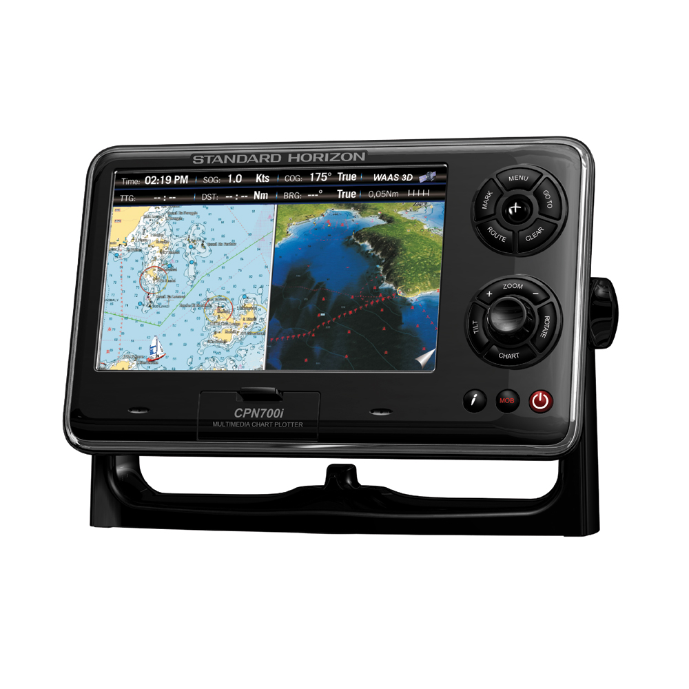
STANDARD HORIZON 10 inch Touchscreen Network Plotter Internal GPS
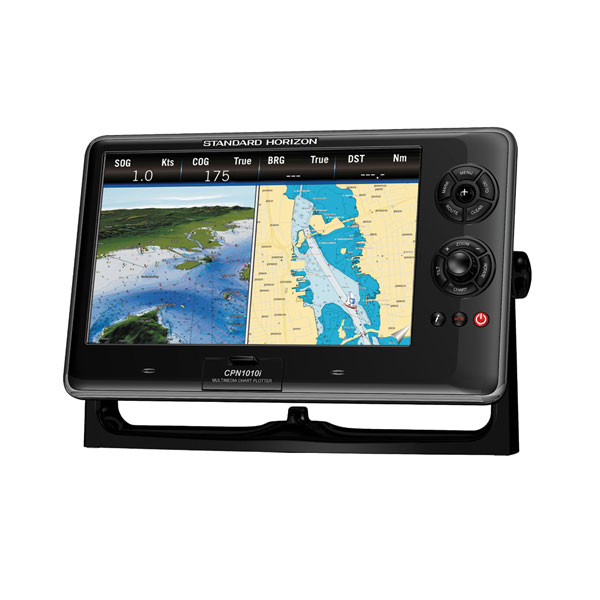
Item: CPN1010i
This item is brand new
$1,999.99
This item ships within 2 days


This item is brand new
$1,999.99
This item ships within 2 days
Communication

010-00892-00
Ais 300
Ais 300
No Longer Available
010-00865-00
Ais 600
Ais 600
No Longer Available
Mounts


Marine Networking

Kjm-c50R
Dome Camera, Surface Mount,Rev. Image
Dome Camera, Surface Mount,Rev. Image
No Longer Available
Kjm-c50-j
Mini Dome Camera, with OSD Switch
Mini Dome Camera, with OSD Switch
No Longer Available
Transducers Standard
FF525
FF525 Black Box Fishfinder, 50/200KHz
FF525 Black Box Fishfinder, 50/200KHz
No Longer Available
Compatible maps
Suggested Maps and Software:
C-Map 4D Charts |
Contents of the package
CPN1010i
Installation hardware
Owner's manual
Features
Standard CPN1010i
Multimedia/Networking Chart Plotter with Built-in C-Map Cartography
The new Standard Horizon CPN1010i will grant you the confidence you need to navigate safely to your destination and gives you something to do along the way. The CPN series plotters come with built in Wi-Fi, multimedia capabilities, USB and Bluetooth technology, Ethernet networking, XM Weather overlay, and more, all on an easy-to-use touch screen display.
With built-in Wi-Fi you will have full internet access from any Wi-Fi hot spot. Stream live music or video and listen effortlessly from the chart plotter?s front panel built-in speakers. Or for improved audio quality take advantage of an auxiliary output to connect your onboard stereo speakers. Check your email or even reply with an onscreen touch sensitive keyboard. If you prefer, connect a mouse and keyboard via Bluetooth or an easily accessible USB port. For onboard entertainment, connect a USB memory drive to the CPN series plotter to watch
movies, view pictures, or listen to music.
When you are ready to depart from a local Wi-Fi hotspot, check your CPN series plotter for up-to-date weather conditions with XM Weather overlay. You can even bring the weather report along, with an optional network XM Weather receiver. Overlay current weather conditions, radar, or AIS information on the CPN series preloaded charts of Coastal US, Canada, Great Lakes, Mexico and the Bahamas. Or purchase the optional C-Map 4D cartography to enable 3D raster, vector, satellite maps, high resolution photos and an intensive Points of Interest list; all with complete control to zoom, rotate and tilt the map at will. Best of all, share radar, user-created points, and
cartography information between two CPN series plotters on our high speed Ethernet network.
The CPN1010i has a 10.4" display and comes equipped with an internal 50 channel WAAS GPS receiver and a connection for an optional external GPS Antenna. The bonded display of the CPN Series achieves superior clarity in direct sunlight. Take advantage of the touch display to zoom in and out and scroll between various navigation pages. The CPN1010i offers 2 video inputs and one VGA video output connection to display the plotter?s image on a separate monitor.
Preloaded with detailed maps for coastal navigation of USA including Alaska, Hawaii and Great Lakes, Canada, Bahamas, Caribbean, Cuba, Puerto Rico, and Central America
Built-in Wi-Fi and Bluetooth capability
Dual station networking capability
Optional C-Map 4D cartography for viewing 3D, raster or vector charts and an intensive library of photos and POI?s
Unique bonded touch display with zoom and swipe capability
CPN1010.4? 10? SVGA 800 x 600 sunlight viewable bonded touch screen display
Internal 50 channel WAAS GPS antenna with external antenna connection
Dual chart window with independent zoom levels
Displays DSC Distress and Position report calls received from a DSC VHF radio
FF525 Fish Finder and Si-TEX MDS Radar capable
AIS capable (third party receiver required)
Two NTSC or PAL Video inputs with Picture In Picture display
3000 Marks / 50 Routes
20 Tracks with 10,000 available track points
Supplied with a mounting bracket and flush mounting hardware
3 Year Waterproof Warranty
Specifications
Display 10.4" diag. widescreen/touchscreen color LCD
Resolution 800 x 600 pixels
Antenna Internal GPS
Mapping Pre-loaded coastal detail for U.S., Canada, Caribbean, and Central America
with satellite images. Optional C-Map 4D
Waypoints/Routes 3,000 waypoints, 50 routes, 20 tracks, 10,000 trackpoints
Sounder FF525 sold separately
Radar Compatible with SiTex MDS radar systems, sold separately
Interface 3 NMEA 0183 in/out ports, USB, Ethernet
Other Functions AIS (receiver required), WiFi Internet, Bluetooth, XM weather (recevier
required), built-in speakers, one video input, VGA output, ability to add
keyboard & mouse though USB port.
Dimensions 12.6"W x 8.4"H x 3.3"D
Warranty Three Years
Item number: CPN1010i
UPC: 788026124138
Package weight: 8 lb
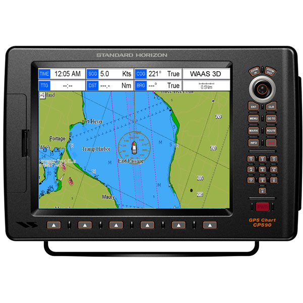
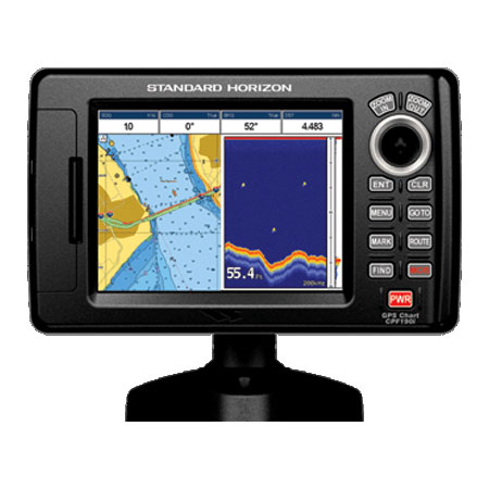
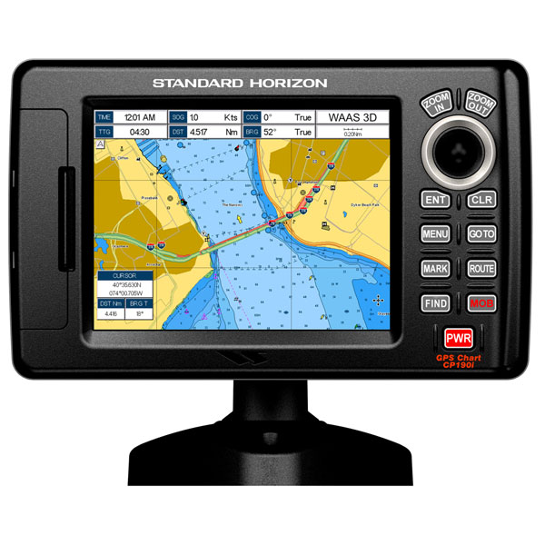
Other Products in the Series: