GARMIN Dakota 20


AC Charger


Speed/Cadence bike sensor (GSC 10)
Heart rate monitor

Premium Heart rate monitor Soft Strap

Tempe Wireless Temperature Sensor


HRM-Pro Heart Rate Monitor with Bluetooth and Running Dynamics

HRM-Pro Plus Heart Rate Monitor


Cup Holder Universal Mount RAM-A-CAN II with 6 in Flex Arm


Chirp Wireless geocaching beacon

BirdsEye Satellite Imagery Retail Card
Virb X
Virb Xe
NOH Virb XE
VIRB XE Cycling Bundle
VIRB XE Auto Racing Bundle
VIRB XE Aviation Bundle
VIRB Camera
VIRB Elite Camera Dark
VIRB Elite Camera
BirdsEye Satellite Imagery US and Canada
Suggested Maps and Software:
 | Inland Lakes |
 | BlueChart g2, g3 on micro SD card with adapter |
 | Garmin Street Maps and City Navigation |
 | Garmin Topographic Maps |
 | Garmin Extras |
Contents of the package
Features
The Dakota 20 combines touchscreen technology with outdoor navigation, along with healthy doses of high-sensitivity GPS with HotFix satellite prediction, barometric altimeter, 3-axis electronic compass and microSD card slot.All in all, its a pretty amazing combination for one of the most powerful, affordable devices on the market.
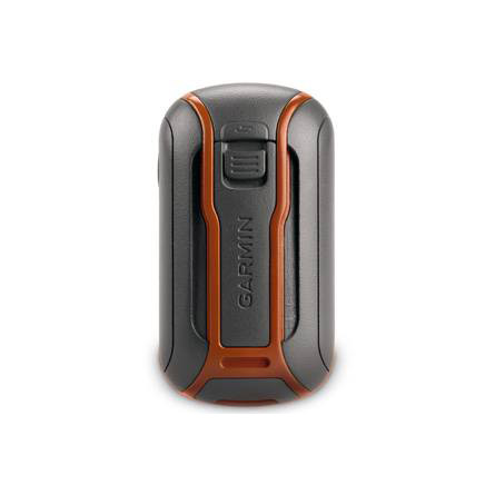
Easy and durable
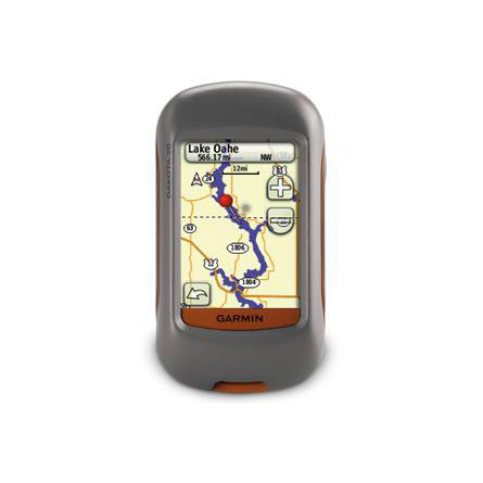
Your Dakota 20 features a durable, sunlight-readable 2.6-inch color touchscreen display. The simple interface means you'll spend more time admiring your surroundings and less time with your face buried in your GPS. Plus, the Dakota 20 stands up to Mother Natures surprises. Not only is it waterproof, it can withstand bumps, dust, dirt and water.
Know exactly where you are
Built into the Dakota 20 is a 3-axis electronic compass, which tells you where you are, even if youre standing still or not holding it level. The barometric altimeter tracks pressure changes to pinpoint your precise altitude. Plus, you can use your Dakota 20 to plot barometric pressure over time to anticipate changing weather. Even in deep canyons or heavy cover, Dakota 20 uses its high-sensitivity, WAAS-enabled GPS receiver and HotFix satellite prediction to find your position quickly and precisely.
Attention geocachers
Paperless geocaching is a breeze with the Dakota 20. You can easily download up to 2,000 caches with information such as location, terrain, difficulty, hints and description. That means you dont need any more paper printouts, and you definitely dont need to manually enter coordinates.
Explore and conquer
Dakota 20 gives you a built-in worldwide basemap, allowing you to navigate anywhere. And if you want to add more maps, just use Garmins detailed topographic, marine and road maps on microSD card.
Go social
Your Dakota 20 allows you to share your waypoints, tracks, geocaches and routes wirelessly with compatible Oregon, Dakota and Colorado and Foretrex users. All you have to do is press send to transfer your favorite route or geocache location.
Specifications
Installed languages: English,
Spanish, French, Deutsch, Italiano, Portugues, Cesky, Dansk,
Nederlands, Norsk, Suomi, Hrvatski, Magyar, Polski, Russian, Svenska,
Turkse, Latvian, Slovak, Slovenian, Greek, Arabic, Farsi, Bulgarian.
More languages may be available through Garmin web updater.
Physical & Performance:
Unit dimensions, WxHxD: 2.2" x 3.9" x 1.3" (5.5 x 10 x 3.3 cm)
Display size, WxH: 1.43"W x 2.15"H (3.6 x 5.5 cm); 2.6" diag (6.6 cm)
Display resolution, WxH: 160 x 240 pixels
Display type: Transflective color TFT touchscreen
Weight: 6.75 oz (191.4 g) with batteries
Battery: 2 AA batteries (not included); NiMH or Lithium recommended
Battery life: 20 hours
Waterproof: yes (IPX7)
Floats: no
High-sensitivity receiver: yes
Interface: USB
RoHS version available: yes
Maps & Memory:
Basemap: yes
Preloaded maps: no
Ability to add maps: yes
Built-in memory: 850 MB
Accepts data cards: microSD card (not included)
Waypoints/favorites/locations: 1000
Routes: 50
Track log: 10,000 points, 200 saved tracks
Features:
Automatic routing (turn by turn routing on roads): yes (with optional mapping for detailed roads)
Electronic compass: yes (tilt-compensated, 3-axis)
Touchscreen: yes
Barometric altimeter: yes
Geocaching-friendly: yes (paperless)
Outdoor GPS games: no
Hunt/fish calendar: yes
Sun and moon information: yes
Tide tables: yes
Area calculation: yes
Custom POIs (ability to add additional points of interest): yes
Unit-to-unit transfer (shares data wirelessly with similar units): yes
Picture viewer: no
Item number: 010-00781-01
UPC: 753759094874
Package weight: 2 lb
 | Video by GPS4US |
 | Video by GPS4US |
 | Video by Garmin |
View latest videos by GPS4US
Visit GPS4US
 Channel.
Following reviews were written by actual customers.
Every GPS4US customer has a chance to live a feedback after receiving a product.
 by Ned P, , 1/29/2013
Great unit at a fair price. Quick and efficient delivery.
by Gizele de M Souza G, , 12/3/2012excellent
by Miguel H, , 9/30/2012Works Great!!!
by Christopher C, , 8/8/2012We absolutely love the GARMIN Dakota 20. It is very easy to use, and is a dream for geocaching. I would reccomend this unit to new/old geocachers.
by Thilak M, , 10/2/2011Yes, very much, excellent piece of equipment, and your understanding and cooperation when carrying out this supply very much appreciated.
by Ronald J, , 2/9/2011I really like it. small & practical. You can zoom in and out on maps. It''s easy to FIND YOUR WAY AROUND ON.
by Alexey P, , 1/25/2011Works well, no problem. Good price.
by Alexey P, , 1/25/2011Other Products in the Series:
| GARMIN Dakota 10 | Add to comparison |
| GARMIN Dakota 10 NOH | Add to comparison |
| GARMIN Dakota 10 Geocaching Bundle | |
| GARMIN Dakota 10 Outdoor and Geocaching Topo Bundle | |
| GARMIN Dakota 10, Bike and Hike Bundle | |
| GARMIN Dakota 20 NOH |