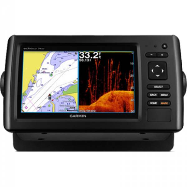
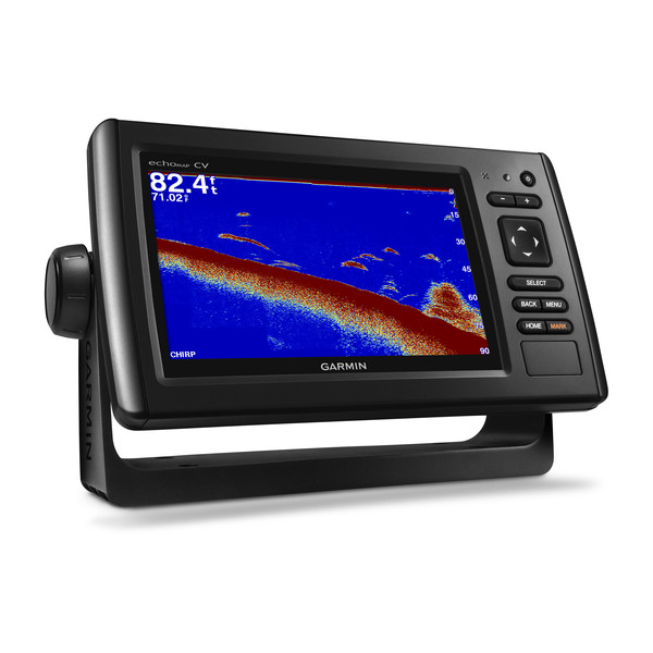
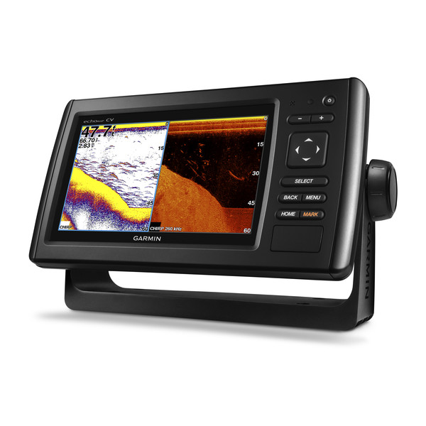
GARMIN EchoMAP CHIRP 74cv with ClearVu Transducer


This item is brand new
$477.95
Backorder, ships in 3 - 4 weeks
|cw|sw|wi


GPS 19x NMEA 2000 GPS Receiver


MotorGuide Adapter Cable 8-pin


Bail Mount with Quick Release Cable 8-pin


Panoptix PS31 Forward Transducer

Panoptix PS60 Thru-hull Down Transducer
Panoptix PS21 LiveVu Forward Transducer
Panoptix PS21-TM Forward Transom Mount Transducer


NMEA 2000 Transducer Adapter Kit

GNT 10 NMEA 2000 - ANT Transceiver


M260-8G 1kW 200/50kHz In-Hull Plastic Transducer


M265LH DO 42 210 kHz 1kW CHIRP In-hull/Pocket Plastic Transducer


R599LH 2-3kW CHIRP Transducer


B175L no connector 1kW 12 tilt CHIRP Bronze Transducer
B175H no connector 1kW 20 tilt CHIRP Bronze Transducer

P72-8G 500W 77/200 kHz Transducer


B175M 8pin1kW 12 tilt CHIRP Transducer

B175M 8pin 1kW 20 tilt CHIRP Transducer


B75H 0 deg tilt CHIRP Transducer


B75L 12 deg tilt CHIRP Transducer


B164 1kW 0 tilt 200/50kHz Bronze Transducer 8-pin


Wide beam bare wires 0 Tilt 150-250 kHz 1kW CHIRP Bronze Transducer
Wide beam bare wires 12 Tilt 150-250 kHz 1kW CHIRP Bronze Transducer
Wide beam bare wires 20 Tilt 150-250 kHz 1kW CHIRP Bronze Transducer
B175H no connector 1kW 0 tilt CHIRP Bronze Transducer
B175H no connector 1kW 12 tilt CHIRP Bronze Transducer
B175L 8pin 1kW 0 tilt CHIRP Bronze Transducer
B175L no connector 1kW 20 tilt CHIRP Bronze Transducer
B175M no connector 1kW 0 tilt CHIRP Bronze Transducer
B175M no connector 1kW 12 tilt CHIRP Bronze Transducer
B175M no connector 1kW 20 tilt CHIRP Bronze Transducer

B265LH CHIRP Transducer
B45-DT-8G Thru-Hull 50/200 kHz Bronz Narrow Stem 8pin Transducer

CM599 LH 2-3kW CHIRP Transducer

CM599 LM 2-3kW CHIRP Pocket Mount Transducer

PM265LM DT 42-135 kHz 1kW CHIRP Poket Bronze Transducer

R109LH 38-210 kHz 2kW CHIRP Urethane Thru-Hull Transducer

R509LH DT 28-210 kHz 2-3kW CHIRP Epoxy Thru-Hull Transducer

R509LM DT 28-130 kHz 2-3kW CHIRP Epoxy Thru-Hull Transducer

SS164 0 deg tilt 1kW Transducer 8pin

SS164 12 deg tilt 1kW Transducer 8 pin

SS164 20 deg tilt 1kW Transducer 8 pin


P32-8G DST 77/200 Khz 45/15 beam Transom Mount 8pin Triducer

TM150M 95-155 kHz Trunsom mount Plastic CHIRP 8pinTransducer
GT21-TM - Transom Mount DownVu 500W CHIRP 260/455 kHz Traditional 600W 50/200 kHz Transducer w/Temp


TM265LH DT 42-210 Khz 1kW CHIRP Urth Transom Transducer

For Garmin TM258-8G DT Cone 3-21 1kW 200/50kHz Transom 8pin Transducer


Airmar Smart Triducer, Plastic Thru, NMEA 2000

Suggested Maps and Software:
 | Inland Lakes |
 | BlueChart g2, g3 Vision |
 | BlueChart g2, g3 on micro SD card with adapter |
 | Garmin Extras |
 | LakeVu HD Ultra |
 | LakeVu HD |
Contents of the package
- echoMAP CHIRP 74cv
- Power/data cable
- Tilt mount
- Quick-release cradle
- Flush mount
- Protective cover
- Transducer (8-pin)
- Transom mount
- Hardware
- Documentation
Features
Fish with the Power of CHIRP7-inch color display with keypad control
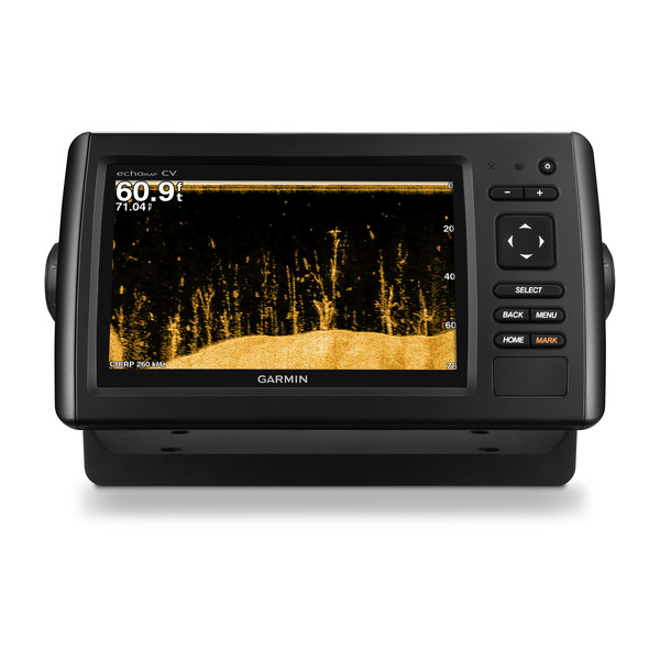
Includes transducer with mid-band CHIRP (85-165 kHz) and Garmin CHIRP ClearVü (600 W)
Preloaded BlueChart® g2 HD charts for the coastal U.S.
Includes Quickdraw Contours custom HD map creation software
Internal 5 Hz GPS updates position and heading 5 times per second
Its time you started fishing with the power of CHIRP sonar. The easy-to-install, easy-to-use 7-inch echoMAP CHIRP 74cv chartplotter includes transducer for high wide CHIRP sonar and Garmin CHIRP ClearVü for clear scanning sonar images. It includes Quickdraw Contours software to instantly create your very own HD maps with 1-foot contours as you fish. Internal 5 Hz GPS updates position and heading 5 times per second. Cords plug directly into the mount, allowing you to quickly install and remove your device from power and mount. Transom and trolling motor mounts included.
The Garmin CHIRP Difference
The built-in sonar capabilities of echoMAP 74cv include CHIRP sonar, the most sophisticated sonar technology available for the fishing and boating public. CHIRP sonar provides amazingly clear target separation and definition because it puts even more energy onto the target than traditional sonar. It also includes sonar-recording capability that coordinates the timing of the sonar return with your boat's position and saves digital information for playback on a computer using HomePort planning software. Use the user data sharing cable to share waypoints and routes between multiple devices.
Clear Scanning Sonar Images
Garmin ClearVü scanning sonar gives you a nearly photographic, wide image of what passes below your boat. You clearly see structure, submerged objects and fish. Traditional Garmin HD-ID sonar and ClearVü scanning sonar are combined into 1 transducer. Also provides HD-ID support for Minn Kota® and MotorGuide® trolling motors with integrated transducers.
Preloaded BlueChart g2 HD Maps
echoMAP CHIRP 74cv is preloaded with BlueChart g2 HD maps covering the coastal U.S. (East Coast, West Coast, Gulf of Mexico, U.S. and Canadian sides of the Great Lakes). It also includes all U.S. charts for the entire coastline as well as everything available on NOAA charts. In addition to the basic charts, tidal stations, currents, depth contours, IALA symbols and included fishing charts, BlueChart g2 HD offers smooth transitioning between zoom levels and more seamless continuity across chart boundaries. Customize your screens with Shallow Water Shading, which allows you to contour shade for all depth contours shallower than what you determine is your safe depth. Fishing charts emphasize bathymetric contours with less visual clutter on the display. And theres also a choice of standard 2-D direct overhead or 3-D over-the-bow map views for easier chart reading and orientation.
Quickdraw Contours to Create Your Own HD Maps
Instantly create personalized HD fishing maps onscreen with 1-foot contours. Tailor them to fit your needs. These are your maps you own them. Keep the data to yourself, or share it with the Quickdraw Community on Garmin Connect.
Heading and Position Refreshed 5 Times per Second
Fast, responsive 5 Hz GPS and GLONASS refreshes your position and heading 5 times each second to make your movement on the screen more fluid. Now its quick and easy to drop up to 5,000 accurate waypoints and find your way back to your secret fishing hot spots.
Take Your echoMAP CHIRP with You
When youre off the water, its easy to keep your echoMAP CHIRP safe and secure. You dont have to mess with plugging and unplugging wires from the unit because the cords plug directly into the mount. This allows you to quickly install and remove your echoMAP CHIRP from power and the mount.
Upgrade to Our Best Maps on the Water
A single microSD card slot provides expandable memory for accessory map purchases, such as LakeVü HD Ultra with Max Def Lakes or BlueChart® g2 Vision® HD, which adds Garmin patented Auto Guidance¹ and other great features.
GPX Waypoints Transfer
If you have waypoints, tracks or frequently used routes stored on another manufacturers GPS product - or on a Garmin handheld device - now its easier than ever to transfer those items to your new Garmin chartplotter, via industry-standard GPX software formatting.
¹Auto Guidance is for planning purposes only and does not replace safe navigation operations.
Specifications
Physical & Performance
| Physical dimensions | 9.8"x5.5"x2" (25cmx13.9cmx5.1cm) |
|---|---|
| Display size, WxH |
6.0"x3.6"; 7.0" diagonal (15.2 x 9.1 cm; 17.8cm diagonal) |
| Display resolution, WxH | 800 x 480 pixels |
| Display type | WVGA display |
| Weight | 1.7 lbs. (0.77kg) |
| Water rating |
IPX7 |
| Antenna | Internal or external over NMEA 2000 |
| NMEA 2000® compatible |
|
| NMEA 0183 compatible |
|
| Power consumption |
6.2W |
| Mounting options | Bail or flush |
| Garmin Marine Network ports |
1 Panoptix port |
Maps & Memory |
|
| Preloaded maps |
BlueChart® g2 (coastal maps) |
|---|---|
| Accepts data cards |
1 microSD card |
| Waypoints |
5,000 |
| Routes | 100 |
| Track log | 50,000 points; 50 saved tracks |
Chartplotter Features |
|
| Garmin Sonar compatible |
Yes |
|---|---|
| Supports AIS (tracks target ships position) |
|
| Supports DSC (displays position data from DSC-capable VHF radio) |
|
| Tide tables |
|
| BlueChart® Mobile (planning) compatible |
No |
| Garmin Helm compatible |
No |
Sonar Features & Specifications |
|
| Dual-frequency (50/200 kHz) sonar capable |
|
|---|---|
| Dual-beam (77/200 kHz) sonar capable |
|
| Frequencies supported |
CHIRP (low, mid, high) Traditional: 50/77/200 kHz ClearVü: 260/455/800 kHz |
| Transmit power | 500 W (RMS) / 4,000 W (peak to peak) |
| CHIRP sonar technology | Yes (Built-in) |
| ClearVü |
Yes with CHIRP (built-in) |
| SideVü |
No |
| Maximum depth |
2,300 ft @ 77 kHz, freshwater 1,100 ft @ 77 kHz, saltwater (depth capacity is dependent on water bottom type and other water conditions) |
| Bottom lock (shows return from the bottom up) |
|
| Water temperature log and graph |
|
| Sonar recording |
|
| Sonar history rewind |
|
Connections |
|
| Transducer pin numbers | 8 |
|---|---|
| NMEA 0183 input ports |
1 |
| NMEA 0183 output ports |
1 |
| Video input ports |
None |
| Video output ports |
None |
| Wireless connectivity |
No |
Product Comparison:
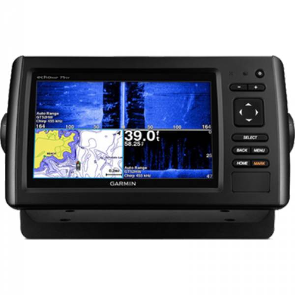
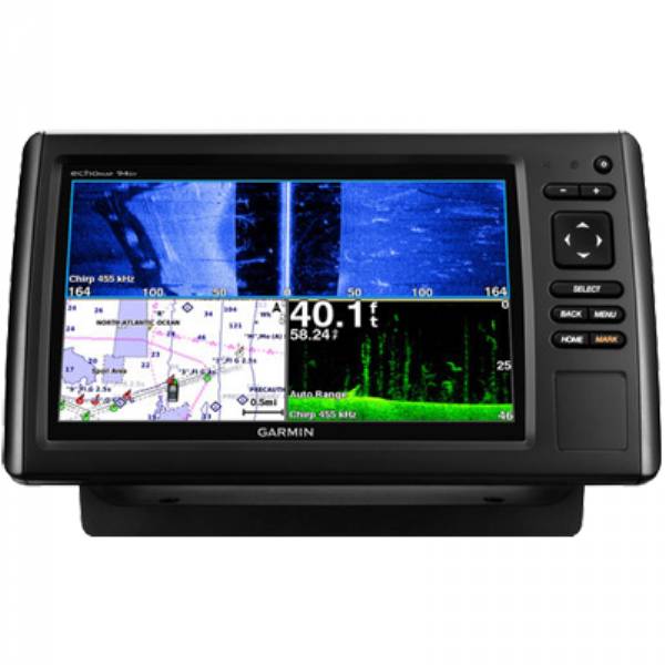
| echoMAP CHIRP 42cv, 43cv, 44cv, 45cv | echoMAP CHIRP 52cv, 53cv, 54cv, 55cv | echoMAP CHIRP 72cv, 73cv, 74cv, 75cv | echoMAP CHIRP 72sv, 73sv, 74sv, 75sv | echoMAP CHIRP 92sv, 93sv, 94sv, 95sv | |
| Display size (diag.) | 4.3 | 5.0 | 7.0 | 7.0 | 9.0 |
| Display resolution | 480 x 272 WQVGA | 480 x 480 square | 480 x 800 WVGA | 480 x 800 WVGA | 480 x 800 WVGA |
| Preloaded maps | 42cv: Worldwide basemap 43cv: U.S. LakeVu HD 44cv: U.S. BlueChart g2 45cv: Canada LakeVu HD | 52cv: Worldwide basemap 53cv: U.S. LakeVu HD 54cv: U.S. BlueChart g2 55cv: Canada LakeVu HD | 72cv: Worldwide basemap 73cv: U.S. LakeVu HD 74cv: U.S. BlueChart g2 75cv: Canada LakeVu HD | 72sv: Worldwide basemap 73sv: U.S. LakeVu HD 74sv: U.S. BlueChart g2 75sv: Canada LakeVu HD | 92sv: Worldwide basemap 93sv: U.S. LakeVu HD 94sv: U.S. BlueChart g2 95sv: Canada LakeVu HD |
| Quickdraw Contours software | | | | | |
| Panoptix sonar support | | | | ||
| Internal 5 Hz GPS receiver | | | | | |
| CHIRP traditional sonar | | | | | |
| Dual frequency (50/200 kHz) | | | | | |
| Dual beam (77/200 kHz) | | | | | |
| CHIRP ClearVu | | | | | |
| CHIRP SideVu | | | |||
| Frequencies supported (kHz) | CHIRP (low, mid, high) Traditional: 50/77/200 ClearVu: 260/455/800* | CHIRP (low, mid, high) Traditional: 50/77/200 ClearVu: 260/455/800* | CHIRP (low, mid, high) Traditional: 50/77/200 ClearVu: 260/455/800* | CHIRP (low, mid, high) Traditional: 50/77/200 ClearVu: 260/455/800* SideVu: 260/455/800* | CHIRP (low, mid, high) Traditional: 50/77/200 ClearVu: 260/455/800* SideVu: 260/455/800* |
| Transmit power - 500 W (RMS)/4,000 W (Peak-to-Peak) | | | | | |
| Maximum depth capabilities - 2,300 ft. at 77 kHz, freshwater | | | | | |
| Accepts microSD card - For optional mapping and user data storage | | | | | |
| NMEA 2000 compatible | | | | | |
| NMEA 0183 compatible - 1 input port/1 output port | | | | | |
| AIS and DSC support | | | | | |
| User Data Sharing Cable compatible | | | | | |
| Sonar history rewind | | | | | |
| Sonar recording | | | | | |
| Bottom lock | | | | | |
| Water temperature log/graph | | | | | |
| Minn Kota and MotorGuide trolling motor transducer compatible | | | | | |
| Tide tables With applicable maps | | | | | |
| Mounting options | Bail/Flush | Bail/Flush | Bail/Flush | Bail/Flush | Bail/Flush |
Item number: 010-01801-01
UPC: 753759176082
Package weight: 7.4 lb
Other Products in the Series: