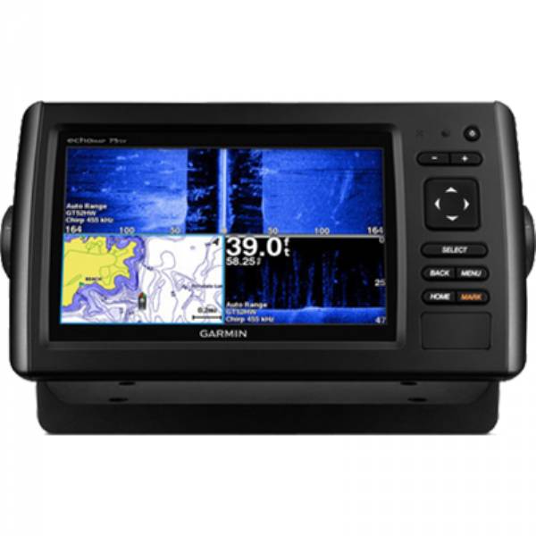
GARMIN EchoMAP CHIRP 75sv with DownVu and SideVu Transducer and LakeVu HD maps for Canada


This item is brand new
$1,099.99
This item ships within 2 days


Bail Mount with Quick Release Cable 12-pin


Panoptix PS31 Forward Transducer

Panoptix PS60 Thru-hull Down Transducer
Panoptix PS21 LiveVu Forward Transducer
Panoptix PS21-TM Forward Transom Mount Transducer


NMEA 2000 Transducer Adapter Kit

GNT 10 NMEA 2000 - ANT Transceiver


GT41-TH Thru-Hull CHIRP DownVu, SideVu, Traditional Transducer with Temp 12-pin
GT41-THP Traditional 600W, 50/200kHz, ClearVu/SideVu CHIRP 260kHz, 455kHz Pair w/Fairing Block
GT50M-TH Thru-Hull CHIRP DownVu, SideVu, CHIRP Traditional Transducer with Temp 12-pin
GT50M-THP Pair Thru-Hull CHIRP DownVu, SideVu, CHIRP Traditional Transducer with Temp 12-pin


GT40-TM Transom CHIRP DownVu, SideVu, Traditional Transducer with Temp 12-pin


M260-8G 1kW 200/50kHz In-Hull Plastic Transducer


M265LH DO 42 210 kHz 1kW CHIRP In-hull/Pocket Plastic Transducer


R599LH 2-3kW CHIRP Transducer


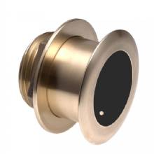
B175L no connector 1kW 12 tilt CHIRP Bronze Transducer
B175H no connector 1kW 20 tilt CHIRP Bronze Transducer

P72-8G 500W 77/200 kHz Transducer


B175M 8pin1kW 12 tilt CHIRP Transducer

B175M 8pin 1kW 20 tilt CHIRP Transducer


B75H 0 deg tilt CHIRP Transducer


B75L 12 deg tilt CHIRP Transducer


B164 1kW 0 tilt 200/50kHz Bronze Transducer 8-pin


Wide beam bare wires 0 Tilt 150-250 kHz 1kW CHIRP Bronze Transducer
Wide beam bare wires 12 Tilt 150-250 kHz 1kW CHIRP Bronze Transducer
Wide beam bare wires 20 Tilt 150-250 kHz 1kW CHIRP Bronze Transducer
B175H no connector 1kW 0 tilt CHIRP Bronze Transducer
B175H no connector 1kW 12 tilt CHIRP Bronze Transducer
B175L 8pin 1kW 0 tilt CHIRP Bronze Transducer
B175L no connector 1kW 20 tilt CHIRP Bronze Transducer
B175M no connector 1kW 0 tilt CHIRP Bronze Transducer
B175M no connector 1kW 12 tilt CHIRP Bronze Transducer
B175M no connector 1kW 20 tilt CHIRP Bronze Transducer

B265LH CHIRP Transducer
B45-DT-8G Thru-Hull 50/200 kHz Bronz Narrow Stem 8pin Transducer

CM599 LH 2-3kW CHIRP Transducer

CM599 LM 2-3kW CHIRP Pocket Mount Transducer

PM265LM DT 42-135 kHz 1kW CHIRP Poket Bronze Transducer

R109LH 38-210 kHz 2kW CHIRP Urethane Thru-Hull Transducer

R509LH DT 28-210 kHz 2-3kW CHIRP Epoxy Thru-Hull Transducer

R509LM DT 28-130 kHz 2-3kW CHIRP Epoxy Thru-Hull Transducer

SS164 0 deg tilt 1kW Transducer 8pin

SS164 12 deg tilt 1kW Transducer 8 pin

SS164 20 deg tilt 1kW Transducer 8 pin


P32-8G DST 77/200 Khz 45/15 beam Transom Mount 8pin Triducer

TM150M 95-155 kHz Trunsom mount Plastic CHIRP 8pinTransducer
GT21-TM - Transom Mount DownVu 500W CHIRP 260/455 kHz Traditional 600W 50/200 kHz Transducer w/Temp


TM265LH DT 42-210 Khz 1kW CHIRP Urth Transom Transducer

For Garmin TM258-8G DT Cone 3-21 1kW 200/50kHz Transom 8pin Transducer


Suggested Maps and Software:
 | Inland Lakes |
 | BlueChart g2, g3 Vision |
 | BlueChart g2, g3 on micro SD card with adapter |
 | Garmin Extras |
 | LakeVu HD Ultra |
 | LakeVu HD |
Contents of the package
- echoMAP 75sv CHIRP with Canada LakeVü HD
- Power/data cable
- Tilt mount
- Quick-release cradle
- Protective cover
- Flush mount kit
- GT52HW-TM transducer (12-pin)
- Transom mount
- Trolling motor mount
- Hardware
- Documentation
Features
Fish with the Power of CHIRP7-inch color display with keypad control
Includes GT52-TM transducer with high wide CHIRP, 250 W and CHIRP DownVü/SideVü, 455/800, 500 W transducer
Panoptix all-seeing sonar support (transducer not included)
Includes Canada LakeVü HD maps cover more than 13,500 lakes, of which more than 1,600 are HD lakes with 1-foot contours shore to shore
Preloaded Quickdraw Contours custom HD map creation software
Its time you started fishing with the power of CHIRP sonar. The easy-to-install, easy-to-use 7-inch echoMAP CHIRP 75sv includes transducer for high wide CHIRP sonar and Garmin CHIRP SideVü and Garmin CHIRP DownVü, the clearest scanning sonars on the water. It supports Panoptix sonar and includes preloaded Quickdraw Contours software to instantly create your own HD maps with 1-foot contours as you fish. Internal 5 Hz GPS updates position and heading 5 times per second. It provides NMEA 2000® support for engine data, sensors, autopilots and more. Cords plug directly into the mount, allowing you to quickly install and remove your device from power and mount. Transom and trolling motor mounts included.
The Garmin CHIRP Difference
The built-in sonar capabilities of echoMAP 75sv include CHIRP sonar, the most sophisticated sonar technology available for the fishing and boating public. CHIRP sonar provides amazingly clear target separation and definition because it puts even more energy onto the target than traditional sonar. It also includes sonar-recording capability that coordinates the timing of the sonar return with your boat's position and saves digital information for playback on a computer using HomePort planning software. Use the user data sharing cable to share waypoints and routes between multiple devices.
Clearest Scanning Sonar on the Water
Garmin CHIRP DownVü and CHIRP SideVü scanning sonars give you nearly photographic images of whats below and to the sides of your boat. You clearly see structure, submerged objects and fish. Also supports Minn Kota® and MotorGuide® trolling motors with integrated transducers.
Preloaded Canada LakeVü HD Maps
These highly detailed freshwater maps include 13,500+ Canada lakes, rivers and reservoirs, including coverage for the Great Lakes and Trent Severn Waterway. That number also includes more than 1,600 HD lakes with 1-foot contours shore to shore in Alberta, British Columbia, Nova Scotia, Ontario, Quebec, Saskatchewan and Yukon provinces. Canada LakeVü HD gives you excellent detail of underwater features, plus Shallow Water Shading allows you to designate a minimum depth. It also shows interstates, highways, general roads and bridges, designated fishing areas, docks, boat ramps, marinas and campgrounds.
Create Your Own HD Maps
Quickdraw Contours is a free, easy-to-use software feature already installed on your echoMAP CHIRP 75sv. It instantly creates your own personalized HD fishing maps on screen with 1-foot contours. Tailor the maps as needed; you own them. Keep the data for yourself, or share it with Garmin or your friends. No special surveying expertise is required. You just fish while Quickdraw Contours creates maps. Theres no waiting around or sending your files away like other mapping software requires your results appear instantly. Use with any Garmin Panoptix transducer, any HD-ID sonar, any CHIRP-enabled, Garmin DownVü transducer or NMEA 2000-compatible depth transducer. Have more than 1 sonar device installed onboard? Quickdraw Contours automatically selects the most capable sonar device to provide the very best results for you.
Heading and Position Refreshed 5 Times per Second
Fast, responsive 5 Hz GPS/GLONASS refreshes your position and heading 5 times each second to make your movement on the screen more fluid. Now its quick and easy to drop up to 5,000 accurate waypoints and find your way back to your secret fishing hot spots.
Add Panoptix LiveVü Forward Sonar
With LiveVü Forward your boat can be moving or stationary. Wherever your trolling motor is pointed, you will see live images of what is happening under the water. Watch your lure as it sinks, and see its depth and movement as you retrieve it. See it move in relationship to structures in the water. See fish swimming, reacting to your bait; if they attack, youll see and feel the hit. Once on the hook, watch the fight on your screen as it happens. With Panoptix LiveVü Forward, you can see it all come to life up to 100 feet away.
Take Your echoMAP with You
When youre off the water, its easy to keep your echoMAP safe and secure. You dont have to mess with plugging and unplugging wires from the unit because the cords plug directly into the mount. This allows you to quickly install and remove your echoMAP from power and the mount.
Upgrade with the Best Garmin Maps on the Water
A single microSD card slot provides expandable memory for accessory map purchases such as Canada LakeVü HD Ultra, BlueChart® g2 or BlueChart® g2 Vision®. Canada LakeVü HD Ultra adds high-resolution relief shading, Dynamic Lake Level and Depth Range Shading. It also provides exclusive Garmin Auto Guidance, a technology that directs you to your hot spots. Based on your boats specifications, Auto Guidance instantly creates a visual path you can follow to avoid shallow water and other charted obstructions.
Enhanced Auto Guidance
Just enter the location where you want to go and patented Garmin Auto Guidance technology instantly searches through relevant charts to create a safe, virtual pathway on the display that helps you avoid low bridges, shallow water and other charted obstructions en route.
With enhanced Version 2.0, you have access to more features and capabilities. Youre able to adjust the calculated Auto Guidance pathway by inserting via points at interim stops or landmarks along your desired route. You can easily review hazard points along your calculated path. And you can even engage your compatible Garmin autopilot to follow the Auto Guidance route, automatically. Other 2.0 enhancements give you the ability to calculate arrival times at any point on your route (great for timing arrivals to correspond with bridge openings and other time-critical events). Better still, you can now save your plotted Auto Guidance paths for future navigation by backing them up on an SD card with your BlueChart g2 Vision or LakeVü HD Ultra cartography¹.
GPX Waypoints Transfer
If you have waypoints, tracks or frequently used routes stored on another manufacturers GPS product - or on a Garmin handheld device - now its easier than ever to transfer those items to your new Garmin chartplotter, via industry-standard GPX software formatting. GPX is an open standard format for GPS data exchange across platforms and applications. With this easy-to-use interface technology, Garmin has taken no waypoint left behind to a whole new level of trade-up convenience.
Multiple Depth Range Shading
Designate up to 10 different depth ranges each with its own color. Makes it easier to view target depths at a glance.
Commission Autopilot from Chartplotter
To make commissioning easier and more convenient, you can handle the entire autopilot commissioning process from your chartplotter screen.
¹BlueChart g2 Vision or LakeVü HD Ultra SD card is required for this technology.
Specifications
Physical & Performance |
|
| Physical dimensions | 9.8"x5.5"x2" (25cmx13.9cmx5.1cm) |
| Display size, WxH |
6.0"x3.6"; 7.0" diagonal (15.2 x 9.1 cm; 17.8cm diagonal) |
| Display resolution, WxH | 800 x 480 pixels |
| Display type | WVGA display |
| Weight | 1.7 lbs. (0.77kg) |
| Water rating |
IPX7 |
| Antenna | Internal or external over NMEA 2000 |
| NMEA 2000® compatible |
|
| NMEA 0183 compatible |
|
| Power consumption |
7.1 W |
| Mounting options | Bail or flush |
| Garmin Marine Network ports |
1 Panoptix port |
Maps & Memory |
|
| Preloaded maps |
Yes (depending on version) |
| Accepts data cards |
1 microSD card |
| Waypoints |
5,000 |
| Routes | 100 |
| Track log | 50,000 points; 50 saved tracks |
Chartplotter Features |
|
| Garmin Sonar compatible |
|
| Supports AIS (tracks target ships position) |
|
| Supports DSC (displays position data from DSC-capable VHF radio) |
|
| Tide tables |
|
| BlueChart® Mobile (planning) compatible |
No |
Sonar Features & Specifications |
|
| Dual-frequency (50/200 kHz) sonar capable |
|
| Dual-beam (77/200 kHz) sonar capable |
|
| Frequencies supported |
CHIRP (low, mid, high) Traditional: 50/77/200 kHz DownVü: 260/455/800 kHz SideVü: 260/455/800 kHz |
| Transmit power | 500 W (RMS) / 4,000 W (peak to peak) |
| CHIRP sonar technology | Yes (Built-in) |
| DownVü |
Yes with CHIRP (built-in) |
| SideVü |
Yes with CHIRP (built-in) |
| Maximum depth |
2,300 ft @ 77 kHz, freshwater 1,100 ft @ 77 kHz, saltwater (depth capacity is dependent on water bottom type and other water conditions) |
| Bottom lock (shows return from the bottom up) |
|
| Water temperature log and graph |
|
| Sonar recording |
|
| Sonar history rewind |
|
Connections |
|
| Transducer Pin Numbers | 12 |
| NMEA 0183 input ports |
1 |
| NMEA 0183 output ports |
1 |
| Video input ports | None |
| Video output ports | None |
| Wireless connectivity |
No |
Product Comparison:
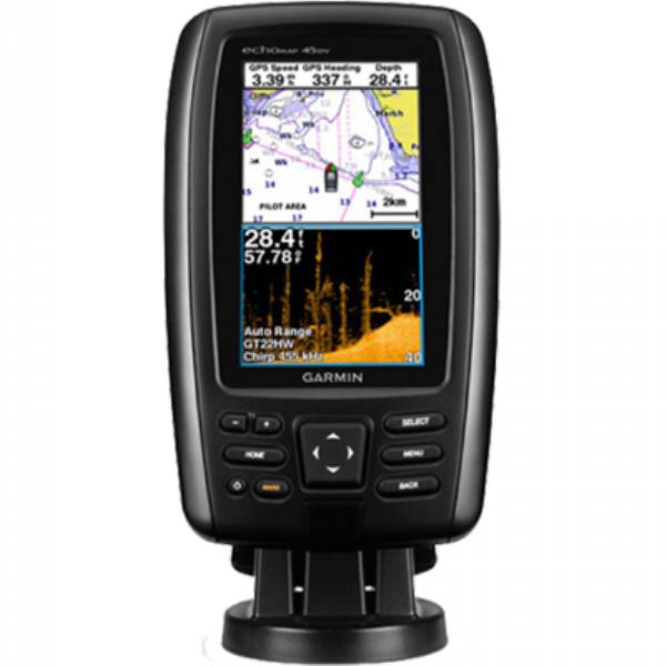
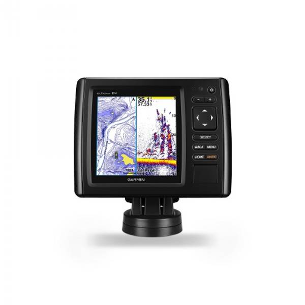
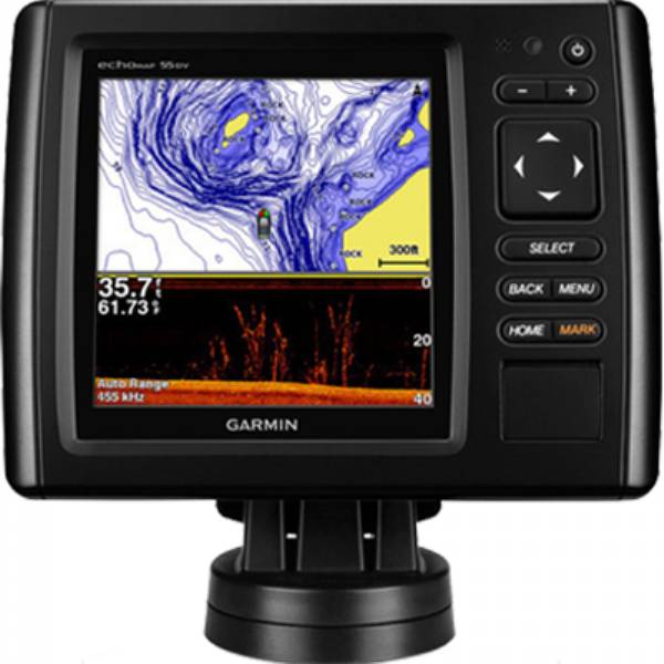
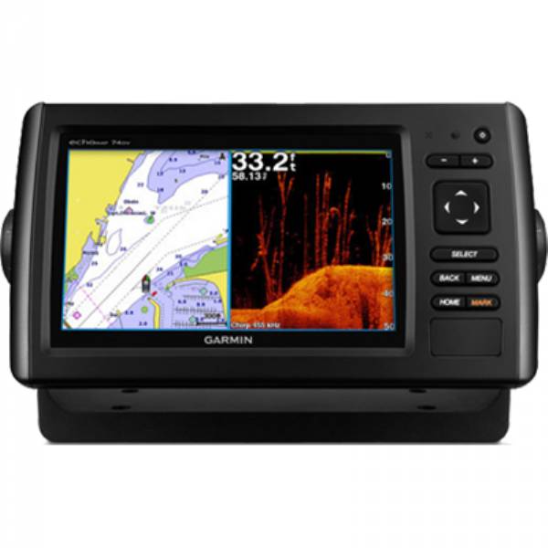
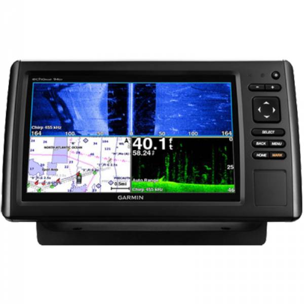
| echoMAP CHIRP 42dv, 43dv, 44dv, 45dv | echoMAP CHIRP 52dv, 53dv, 54dv, 55dv | echoMAP CHIRP 72dv, 73dv, 74dv, 75dv | echoMAP CHIRP 72sv, 73sv, 74sv, 75sv | echoMAP CHIRP 92sv, 93sv, 94sv, 95sv | |
| Display size (diag.) | 4.3 | 5.0 | 7.0 | 7.0 | 9.0 |
| Display resolution | 480 x 272 WQVGA | 480 x 480 square | 480 x 800 WVGA | 480 x 800 WVGA | 480 x 800 WVGA |
| Preloaded maps | 42dv: Worldwide basemap 43dv: U.S. LakeVu HD 44dv: U.S. BlueChart g2 45dv: Canada LakeVu HD | 52dv: Worldwide basemap 53dv: U.S. LakeVu HD 54dv: U.S. BlueChart g2 55dv: Canada LakeVu HD | 72dv: Worldwide basemap 73dv: U.S. LakeVu HD 74dv: U.S. BlueChart g2 75dv: Canada LakeVu HD | 72sv: Worldwide basemap 73sv: U.S. LakeVu HD 74sv: U.S. BlueChart g2 75sv: Canada LakeVu HD | 92sv: Worldwide basemap 93sv: U.S. LakeVu HD 94sv: U.S. BlueChart g2 95sv: Canada LakeVu HD |
| Quickdraw Contours software | | | | | |
| Panoptix sonar support | | | | ||
| Internal 5 Hz GPS receiver | | | | | |
| CHIRP traditional sonar | | | | | |
| Dual frequency (50/200 kHz) | | | | | |
| Dual beam (77/200 kHz) | | | | | |
| CHIRP DownVu | | | | | |
| CHIRP SideVu | | | |||
| Frequencies supported (kHz) | CHIRP (low, mid, high) Traditional: 50/77/200 DownVu: 260/455/800* | CHIRP (low, mid, high) Traditional: 50/77/200 DownVu: 260/455/800* | CHIRP (low, mid, high) Traditional: 50/77/200 DownVu: 260/455/800* | CHIRP (low, mid, high) Traditional: 50/77/200 DownVu: 260/455/800* SideVu: 260/455/800* | CHIRP (low, mid, high) Traditional: 50/77/200 DownVu: 260/455/800* SideVu: 260/455/800* |
| Transmit power - 500 W (RMS)/4,000 W (Peak-to-Peak) | | | | | |
| Maximum depth capabilities - 2,300 ft. at 77 kHz, freshwater | | | | | |
| Accepts microSD card - For optional mapping and user data storage | | | | | |
| NMEA 2000 compatible | | | | | |
| NMEA 0183 compatible - 1 input port/1 output port | | | | | |
| AIS and DSC support | | | | | |
| User Data Sharing Cable compatible | | | | | |
| Sonar history rewind | | | | | |
| Sonar recording | | | | | |
| Bottom lock | | | | | |
| Water temperature log/graph | | | | | |
| Minn Kota and MotorGuide trolling motor transducer compatible | | | | | |
| Tide tables With applicable maps | | | | | |
| Mounting options | Bail/Flush | Bail/Flush | Bail/Flush | Bail/Flush | Bail/Flush |
Item number: 010-01577-00
UPC: 753759147761
Package weight: 7.3 lb
Other Products in the Series: