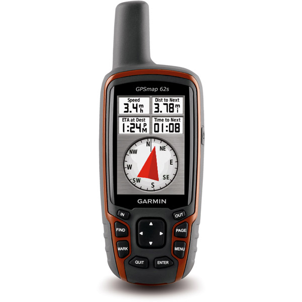
GARMIN GPSMAP 62s


AC Charger


GA 27C low-profile remote automobile antenna

GA 25MCX low profile remote GPS antenna


Speed/Cadence bike sensor (GSC 10)
Heart rate monitor

Premium Heart rate monitor Soft Strap

Tempe Wireless Temperature Sensor


HRM-Pro Heart Rate Monitor with Bluetooth and Running Dynamics

HRM-Pro Plus Heart Rate Monitor


Cup Holder Universal Mount RAM-A-CAN II with 6 in Flex Arm


Chirp Wireless geocaching beacon

BirdsEye Satellite Imagery Retail Card
Virb X
Virb Xe
NOH Virb XE
VIRB XE Cycling Bundle
VIRB XE Auto Racing Bundle
VIRB XE Aviation Bundle
VIRB Camera
VIRB Elite Camera Dark
VIRB Elite Camera
BirdsEye Satellite Imagery US and Canada
Suggested Maps and Software:
 | Inland Lakes |
 | BlueChart g2, g3 on micro SD card with adapter |
 | Garmin Street Maps and City Navigation |
 | Garmin Topographic Maps |
 | LakeVu HD |
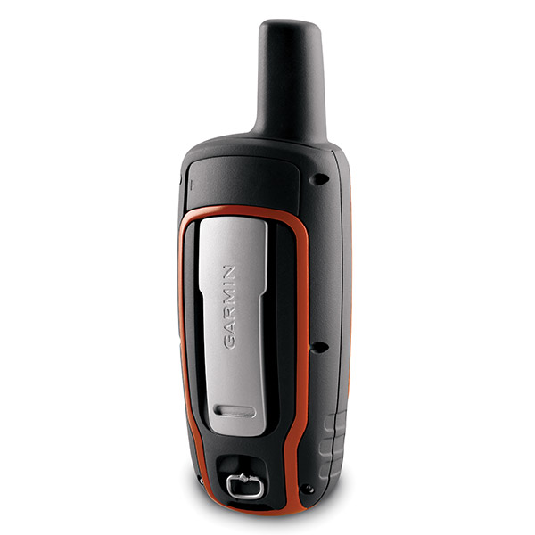
Contents of the package
Features
The newly designed GPSMAP 62s handheld navigator is loaded with amazing features. Itgives you a 3-axis tilt-compensated compass, a barometric altimeter and supports
Custom Maps, BirdsEye Satellite imagery (subscription required) and photo navigation.
Not only is it waterproof, its quad helix antenna gives you unmatched reception. It
also has a high-speed USB connection, a beautiful new design and connects wirelessly
to compatible Garmin handhelds.
Become and explorer
Its built-in basemap with shaded relief makes the GPSMAP 62s a valuable companion
wherever you go. Photo navigation allows you to download and navigate to photos from
Garmin Connect Photos.
Know where you are
A 3-axis tilt-compensated electronic compass is built in to your GPSMAP 62s, so
youll know your heading even if you arent standing still or holding it level. And
the barometric altimeter tracks pressure changes to give you an accurate altitude
reading. You can even use it to plot barometric pressure over time, which helps you
anticipate changing weather.
Go social
Your GPSMAP 62s allows you to share waypoints, tracks, geocaches and routes
wirelessly with other compatible Garmin devices. Just press send to transfer your
information to your friends.
Know where you are
GPSMAP 62s has a quad helix antenna that combines with high-sensitivity WAAS-enabled
GPS receiver and HotFix satellite prediction to determine your location quickly and
accurately, no matter your surrounding terrain.
Customize your maps
With Garmins collection of detailed topographic, marine and road maps, you can add
and customize your GPSMAP 62s maps. Your device features 1.7 gigabytes of onboard
memory and you can download 24K and 100k topo maps for your day on the trails. If
youre hitting the water, just insert BlueChart g2 preloaded cards. And if youre
preparing for a road trip, City Navigator NT map data provides turn-by-turn
directions. GPSMAP 62s supports subscription-based BirdsEye Satellite Imagery, which
integrates satellite images with your maps. And, GPSMAP 62s is compatible with the
free software Custom Maps, which transforms paper and electronic maps into
downloadable files.
All your data in one place
With a connection to your computer and the internet, you can get detailed analysis of
your activities, and send tracks to your outdoor device with Garmin Connect. Youll
get activity tables and a chance to see your activities on a Google Earth map. You
can explore routes uploaded by millions of Garmin Connect users, and share your
experience on Twitter and Facebook.
A geocachers dream
Your GPSMAP 62s can download geocaching GPX files. Your paperless geocaching not only
helps the environment, but makes your geocaching easier. GPSMAP 62s stores and
displays key details, including terrain, location, difficulty, hints and
descriptions. You wont need any more printouts or manually-entered coordinates.
Just upload the GPX file to your unit and start hunting.
Specifications
Installed languages: English,
Spanish, French, Deutsch, Italiano, Portugues, Cesky, Dansk,
Nederlands, Norsk, Suomi, Hrvatski, Magyar, Polski, Russian, Svenska,
Turkse, Latvian, Slovak, Slovenian, Greek, Arabic, Farsi, Bulgarian, Romana.
More languages may be available through Garmin web updater.
Physical & Performance:
Unit dimensions, WxHxD: 2.4" x 6.3" x 1.4" (6.1 x 16.0 x 3.6 cm)
Display size, WxH: 1.6" x 2.2" (4.1 x 5.6 cm); 2.6" diag (6.6 cm)
Display resolution, WxH: 160 x 240 pixels
Display type: transflective, 65-K color TFT
Weight: 9.2 oz (260.1 g) with batteries
Battery: 2 AA batteries (not included); NiMH or Lithium recommended
Battery life: 20 hours
Waterproof: yes (IPX7)
Floats: no
High-sensitivity receiver: yes
Interface: high-speed USB and NMEA 0183 compatible
Maps & Memory:
Basemap: yes
Ability to add maps: yes
Built-in memory: 1.7 GB
Accepts data cards: microSD card (not included)
Waypoints/favorites/locations: 2000
Routes: 200
Track log: 10,000 points, 200 saved tracks
Features:
Automatic routing (turn by turn routing on roads): yes (with optional mapping for detailed roads)
Electronic compass: yes (tilt-compensated, 3-axis)
Touchscreen: no
Barometric altimeter: yes
Camera: no
Geocaching-friendly: yes (paperless)
Custom maps compatible: yes
Photo navigation (navigate to geotagged photos): yes
Outdoor GPS games: no
Hunt/fish calendar: yes
Sun and moon information: yes
Tide tables: yes
Area calculation: yes
Custom POIs (ability to add additional points of interest): yes
Unit-to-unit transfer (shares data wirelessly with similar units): yes
Picture viewer: no
Garmin Connect compatible (online community where you analyze, categorize and share data): yes
Item number: 010-00868-01
UPC: 753759100872
Package weight: 2 lb
 | Video by GPS4US |
 | Video by GPS4US |
 | Video by GARMIN |
 | Video by GPS4US |
 | Video by GPS4US |
 | Video by GPS4US |
 | Video by GPS4US |
 | Video by Garmin |
 | Video by Garmin |
 | Video by Garmin |
 | Video by Garmin |
View latest videos by GPS4US
Visit GPS4US
 Channel.
Following reviews were written by actual customers.
Every GPS4US customer has a chance to live a feedback after receiving a product.
TOP 20 DISPLAYED
 by Daryl O, , 2/17/2015
Fantastic product, but even better service from GPS4US. Thanks Daryl
by yong chang Y, , 12/3/2014Good! easy to use!
by oliver B, , 10/29/2014this and ''a very good article. ship ''was fast. I am very satisfied. thanks to your team
by Steven S, , 10/13/2014Excellent GPS
by Peter G, , 9/27/2014Excellent product, especially when loaded with topo maps!
by Basil C, , 9/22/2014Excellent company to do business with!
 by CESAR D L, , 6/3/2014
Very good.
by Sam J, , 1/22/2013Seems good but I haven''t used it yet and probably wont for another month or so. Is there anything I need to submit to make sure I have the warranty that I paid for.
by HIROSHI F, , 12/14/2012works great and easy to use.
by Joffre I, , 9/5/2012works good
by Joffre I, , 9/1/2012was good
by gizele D, , 8/24/2012excellent
by Cesar F Arriaga G, , 8/17/2012excelent
by Galin P, , 3/7/2012Great product, Happy with everything
by David S, , 1/9/2012awesome!
by Galin P, , 11/17/2011I liked new rugged and waterproof design which makes my new 62s very convenient to hold and operate. The new feature of wireless connectivity to other folks on geocaching team is wonderful. It definitely has much better GPS signal reception with new quad helix antenna, compared to my older handheld, outdoors and in the woods, under the cover, the difference in much better satellite signal reception is very impressive. An excellent product and I am happy with it.
by Cesar F Arriaga G, , 11/14/2011perfect ok!!
by Atanas P, , 7/26/2011Good GPS, many features
by Yang Sul K, , 7/21/2011Very good!!!
by Tom N, , 7/11/2011Am very happy with it thus far. It''s a big change from the 60csx, but I''m optimistic. Thanks for the prompt deliver.
Read all
Other Products in the Series:
| GARMIN Gpsmap 62 NOH | |
| GARMIN Gpsmap 62 | Add to comparison |
| GARMIN GPSMAP 62s NOH | Add to comparison |
| GARMIN GPSMAP 62s, 24k Topo Map Bundle NOH | |
| GARMIN GPSMAP 62sc NOH | |
| GARMIN GPSMAP 62sc | Add to comparison |
| GARMIN GPSMAP 62st NOH | Add to comparison |
| GARMIN GPSMAP 62st | Add to comparison |
| GARMIN GPSMAP 62stc | Add to comparison |
| GARMIN GPSMAP 62stc NOH |