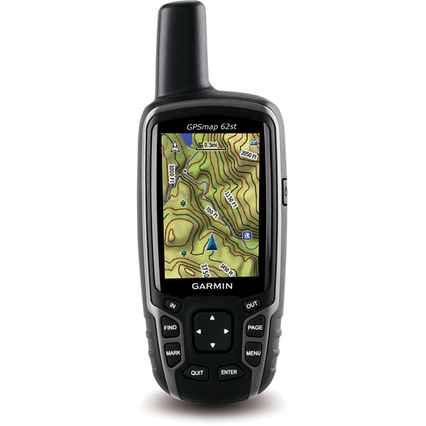
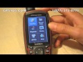
GARMIN GPSMAP 62st


AC Charger


GA 27C low-profile remote automobile antenna

GA 25MCX low profile remote GPS antenna


Speed/Cadence bike sensor (GSC 10)
Heart rate monitor

Premium Heart rate monitor Soft Strap

Tempe Wireless Temperature Sensor


HRM-Pro Heart Rate Monitor with Bluetooth and Running Dynamics

HRM-Pro Plus Heart Rate Monitor


Cup Holder Universal Mount RAM-A-CAN II with 6 in Flex Arm


Chirp Wireless geocaching beacon

BirdsEye Satellite Imagery Retail Card
Virb X
Virb Xe
NOH Virb XE
VIRB XE Cycling Bundle
VIRB XE Auto Racing Bundle
VIRB XE Aviation Bundle
VIRB Camera
VIRB Elite Camera Dark
VIRB Elite Camera
BirdsEye Satellite Imagery US and Canada
Suggested Maps and Software:
 | Inland Lakes |
 | BlueChart g2, g3 on micro SD card with adapter |
 | Garmin Street Maps and City Navigation |
 | Garmin Topographic Maps |
 | LakeVu HD |
Contents of the package
Features
The newly designed GPSMAP 62st handheld navigator is loaded with amazing features. It
gives you a 3-axis tilt-compensated compass, a barometric altimeter and supports
Custom Maps, BirdsEye Satellite imagery (subscription required) and photo navigation.
Not only is it waterproof, its quad helix antenna gives you unmatched reception. It
also has a high-speed USB connection, a beautiful new design and connects wirelessly
to compatible Garmin handhelds.
Become and explorer
The GPSMAP 62st is perfect for climbing at hiking. It comes preloaded with US 100k
topographic map data for the continental US, along with a worldwide basemap with
shaded relief. Your maps show you national, state and local parks and forests, and
terrain contours, elevation, trails, rivers, lakes and points of interest.
Know where you are
A 3-axis tilt-compensated electronic compass is built in to your GPSMAP 62st, so
youll know your heading even if you arent standing still or holding it level. And
the barometric altimeter tracks pressure changes to give you an accurate altitude
reading. You can even use it to plot barometric pressure over time, which helps you
anticipate changing weather.
Go social
Your GPSMAP 62st allows you to share waypoints, tracks, geocaches and routes
wirelessly with other compatible Garmin devices. Just press send to transfer your
information to your friends.
Know where you are
GPSMAP 62st has a quad helix antenna that combines with high-sensitivity WAAS-enabled
GPS receiver and HotFix satellite prediction to determine your location quickly and
accurately, no matter your surrounding terrain.
Customize your maps
With Garmins collection of detailed topographic, marine and road maps, you can add
and customize your GPSMAP 62st maps by using its onboard memory to download 24K and
100k topo maps for your day on the trails. If youre hitting the water, just insert
BlueChart g2 preloaded cards. And if youre preparing for a road trip, City Navigator
NT map data provides turn-by-turn directions. GPSMAP 62st supports subscription-based
BirdsEye Satellite Imagery, which integrates satellite images with your maps. And,
GPSMAP 62st is compatible with the free software Custom Maps, which transforms paper
and electronic maps into downloadable files.
All your data in one place
With a connection to your computer and the internet, you can get detailed analysis of
your activities, and send tracks to your outdoor device with Garmin Connect. Youll
get activity tables and a chance to see your activities on a Google Earth map. You
can explore routes uploaded by millions of Garmin Connect users, and share your
experience on Twitter and Facebook.
A geocachers dream
Your GPSMAP 62st can download geocaching GPX files. Your paperless geocaching not
only helps the environment, but makes your geocaching easier. GPSMAP 62st stores and
displays key details, including terrain, location, difficulty, hints and
descriptions. You wont need any more printouts or manually-entered coordinates.
Just upload the GPX file to your unit and start hunting.
Specifications
Installed languages: English,
Spanish, French, Deutsch, Italiano, Portugues, Cesky, Dansk,
Nederlands, Norsk, Suomi, Hrvatski, Magyar, Polski, Russian, Svenska,
Turkse, Latvian, Slovak, Slovenian, Greek, Arabic, Farsi, Bulgarian, Romana.
More languages may be available through Garmin web updater.
Unit dimensions, WxHxD 2.4" x 6.3" x 1.4" (6.1 x 16.0 x 3.6 cm)
Display size, WxH 1.43" x 2.15" (3.6 x 5.5 cm); 2.6" diag (6.6 cm)
Display resolution, WxH 160 x 240 pixels
Display type transflective, 65-K color TFT
Weight 9.2 oz (260.1 g) with batteries
Battery 2 AA batteries (not included); NiMH or Lithium recommended
Battery life 20 hours
Waterproof Yes (IPX7)
Floats No
High-sensitivity receiver Yes
Interface high-speed USB and NMEA 0183 compatible
Maps & Memory:
Basemap Yes
Preloaded maps yes (topographic)
Ability to add maps Yes
Built-in memory 3.5GB
Accepts data cards microSD card (not included)
Waypoints/favorites/locations 2000
Routes 200
Track log 10,000 points, 200 saved tracks
Features & Benefits:
Automatic routing (turn by turn routing on roads) Yes (with optional mapping for detailed roads)
Electronic compass Yes (tilt-compensated 3-axis)
Touchscreen No
Barometric altimeter Yes
Camera no
Geocaching-friendly Yes (Paperless)
Custom maps compatible Yes
Photo navigation (navigate to geotagged photos) Yes
Hunt/fish calendar Yes
Sun and moon information Yes
Tide tables productTemplate.tab.specs.picklist.yes_with_optional_bluechart
Area calculation Yes
Custom POIs (ability to add additional points of interest) Yes
Unit-to-unit transfer (shares data wirelessly with similar units) Yes
Picture viewer Yes
Garmin Connect compatible (online community where you analyze, categorize and share data) Yes
Item number: 010-00868-02
UPC: 753759100889
Package weight: 2 lb
 | Video by GPS4US |
 | Video by GPS4US |
 | Video by GARMIN |
 | Video by GPS4US |
 | Video by GPS4US |
 | Video by GPS4US |
 | Video by GPS4US |
 | Video by Garmin |
 | Video by Garmin |
 | Video by Garmin |
 | Video by Garmin |
View latest videos by GPS4US
Visit GPS4US
 Channel.
Following reviews were written by actual customers.
Every GPS4US customer has a chance to live a feedback after receiving a product.
 by Maxim T, , 11/15/2010
Works great, everythin as I expected
Other Products in the Series:
| GARMIN Gpsmap 62 NOH | |
| GARMIN Gpsmap 62 | Add to comparison |
| GARMIN GPSMAP 62s | Add to comparison |
| GARMIN GPSMAP 62s NOH | Add to comparison |
| GARMIN GPSMAP 62s, 24k Topo Map Bundle NOH | |
| GARMIN GPSMAP 62sc NOH | |
| GARMIN GPSMAP 62sc | Add to comparison |
| GARMIN GPSMAP 62st NOH | Add to comparison |
| GARMIN GPSMAP 62stc NOH | |
| GARMIN GPSMAP 62stc | Add to comparison |