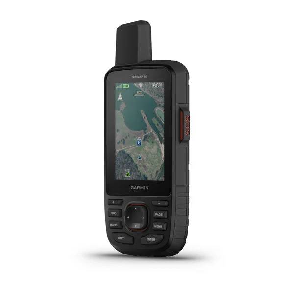
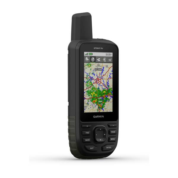
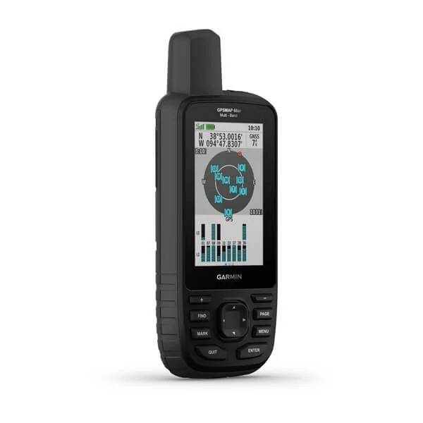
GARMIN GPSMAP 66i with Satellite Communicator


This item is brand new
$499.95
This item ships within 1 day
|pe


Speed/Cadence bike sensor (GSC 10)
Heart rate monitor

Premium Heart rate monitor Soft Strap

Tempe Wireless Temperature Sensor


Heart rate monitor HRM-Run

Heart rate monitor HRM-Tri

Heart rate monitor HRM-Run

HRM-Pro Heart Rate Monitor with Bluetooth and Running Dynamics

HRM-Pro Plus Heart Rate Monitor

Bike Speed Sensor 2

Bike Cadence Sensor 2

Bike Speed Sensor 2 and Cadence Sensor 2 Bundle


Dashboard mount, for second vehicle use


Cup Holder Universal Mount RAM-A-CAN II with 6 in Flex Arm


Lanyard 17 inch


Carabiner clip

Lanyard Carabiner

Chirp Wireless geocaching beacon

BirdsEye Satellite Imagery Retail Card
Virb X
Virb Xe
NOH Virb XE
VIRB XE Cycling Bundle
VIRB XE Auto Racing Bundle
VIRB XE Aviation Bundle
VIRB Ultra 30
VIRB Camera
VIRB Elite Camera Dark
VIRB Elite Camera
BirdsEye Satellite Imagery US and Canada
Suggested Maps and Software:
 | Inland Lakes |
 | BlueChart g2, g3 on micro SD card with adapter |
 | Garmin Street Maps and City Navigation |
 | Garmin Topographic Maps |
 | LakeVu HD |
Contents of the package
Access to Birdseye Satellite Imagery
USB cable
Carabiner clip
Documentation
Features
MORE ADVENTURE. LESS WORRY.Precise navigation meets global communication in the rugged GPSMAP 66i button-operated GPS handheld and satellite communicator1 featuring Garmin TopoActive mapping and inReach® technology.
Need assistance? Send interactive SOS alerts anytime, from anywhere in the world.
No matter where you are, two-way messaging lets you connect to the ones who matter.
Let loved ones know precisely where youre roaming with location tracking and sharing.
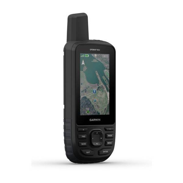
Get maps as pretty as a picture and just as detailed without a subscription.
Know the terrain before youre in it, with preloaded TopoActive maps of the U.S. and Canada.
Stay out there longer with up to 35 hours of battery life in tracking mode and up to 200 hours in Expedition mode.
MULTI-GNSS SUPPORT
Access multiple global navigation satellite systems (GPS and GLONASS) to track in more challenging environments than GPS alone.
ABC SENSORS
Navigate every trail with ABC sensors, including an altimeter for elevation data, barometer to monitor weather and 3-axis electronic compass.
BIRDSEYE SATELLITE IMAGERY
Download high-resolution, photo-realistic maps directly to your device without an annual subscription. Easily find trails, pick stand locations, find parking, create waypoints and more.
PRELOADED TOPO MAPS
Preloaded TopoActive U.S. and Canada maps show you terrain contours, topographic elevations, summits, parks, coastlines, rivers, lakes and geographical points.
TWO-WAY MESSAGING
Exchange text messages with loved ones, post to social media, or communicate from inReach to inReach in the field (satellite subscription required).
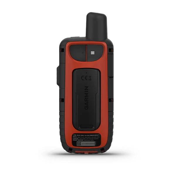
INTERACTIVE SOS ALERTS
In case of emergency, trigger an interactive SOS message to GEOS, a professional 24/7 global monitoring and response center (satellite subscription required).
LOCATION SHARING
Track your location, and share it with those at home or out in the field. Theyll be able to see your progress or ping your device for your GPS location and more (satellite subscription required).
100% GLOBAL IRIDIUM® SATELLITE NETWORK
Instead of relying on cellphone coverage, now your messages, SOS alerts and tracking are transferred via the global Iridium satellite network (satellite subscription required).
OPTIONAL INREACH WEATHER
Use inReach connectivity to get detailed weather updates on GPSMAP 66i or a compatible device paired with the Garmin Explore app. Request weather forecasts for your current location, waypoints or destinations on your route.
ACTIVE WEATHER
When paired with your compatible smartphone, you can get real-time forecast information and live weather radar, so youre always aware of the surrounding conditions.
BUILT FOR ADVENTURE
This handheld is built to military standards for thermal, shock and water performance (MIL-STD-810), and its even compatible with night vision goggles.
LED FLASHLIGHT
The GPSMAP 66 series helps you keep gear to a minimum with a built-in LED flashlight that can be used as a beacon to signal for help.
GARMIN EXPLORE APP
Plan, review and sync waypoints, routes and tracks by using the Garmin Explore mobile app and website. You can even review completed activities while still in the field.
BATTERY LIFE
Turn on Expedition mode, and get up to 200 hours of battery life while using inReach technology. In the default tracking mode, you get up to 35 hours of battery life, and your device will save your location every 10 minutes.
Specifications
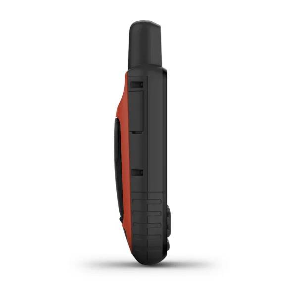
GeneralPhysical dimensions: 2.6" x 6.4" x 1.4" (6.6 x 16.3 x 3.5 cm)
Display size: 1.5"W x 2.5"H (3.8 x 6.3 cm); 3" diag (7.6 cm)
Display resolution: 240 x 400 pixels
Display type: transflective color TFT
Weight: 8.5 oz (241 g)
Battery: rechargeable, internal lithium-ion
Battery life: up to 35 hours at 10-minute tracking; up to 200 hours at 30-minute tracking (power save mode)
Water rating: IPX7
Memory/History: 16 GB
High-sensitivity receiver: yes
Interface: high-speed USB and NMEA 0183 compatible
Maps & Memory
Preloaded maps: yes (topographic)
Ability to add maps: yes
Basemap: yes
Storage and Power Capacity: microSD card (not included)
Waypoints/favorites/locations: 10000
Routes: 250
Track log: 20,000 points, 250 saved gpx tracks, 300 saved fit activities
Sensor
Barometric altimeter: Yes
Compass: Yes (tilt-compensated 3-axis)
Outdoor Recreation Features
Area calculation: Yes
Automatic routing (turn by turn routing on roads): Yes (with optional mapping for detailed roads)
Geocaching-friendly: Yes (Paperless)
Custom maps compatible: Yes
Hunt/fish calendar: Yes
Sun and moon information: Yes
Picture viewer: Yes
Garmin Connect
Garmin Connect compatible (online community where you analyze, categorize and share data): Yes
Additional
Trigger an interactive SOS with 24/7 search and rescue monitoring center: yes
Send and receive text messages to SMS and email: yes
Send and receive messages with other inReach® users, exchange locations: yes
Track and share location with friends and family on web-based MapShare® portal: yes
Virtual keyboard for custom text messaging: yes
Garmin Explore compatible: yes
Garmin Connect IQ compatible: yes
Wireless compatible: yes (Wi-Fi®, BLUETOOTH® and ANT+®)
Map segments: 15,000
Active weather: yes
Request weather forecasts for current location and planned destination: yes
Smart Notifications: yes
Live Tracking: yes (with Garmin Explore)
BirdsEye direct to device: yes (no annual subscription required)
MIL STD 810G ruggedness for thermal, shock and water performance
RINEX Logging: yes
Item number: 010-02088-01
UPC: 753759218737
Package weight: 0.9 lb
Other Products in the Series:
 | GARMIN GPSMAP 66s NOH | Add to comparison |
 | GARMIN GPSMAP 66s | Add to comparison |
 | GARMIN GPSMAP 66s Refurbished, Used, Good condition NOH | |
 | GARMIN GPSMAP 66sr Multi-Band/GNSS | Add to comparison |
 | GARMIN GPSMAP 66st | Add to comparison |