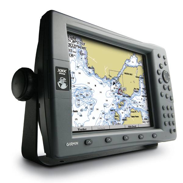
GARMIN Gpsmap 3010C


This item is brand new
$1,866.99
This item ships within 9 days


Gdl 30A

GSD 26 Digital Sonar
GSD 21 Analog Sonar
GSD 22 Digital Sonar

Vehicle power cable

16 MB data card, RoHS

32 MB data card, RoHS

64 MB data card, RoHS

128 MB data card, RoHS

256 MB data card, RoHS
512 MB data card, RoHS


Split Connector 50 ft Right Angle RJ45 Plug
GMR 18 HD Radar

GMR 604 xHD Open Array and Pedestal

GMR 606 xHD Open Array and Pedestal

GMR 1204 xHD Open Array and Pedestal

GMR 1206 xHD Open Array and Pedestal

GMR 404/406 Radar Pedestal
GMR 404 Open Array Radar
GMR 406 Open Array Radar
GMR 18 Radar

GMR 24 Radar
GMR 24 HD Radar
GMR 404 xHD Open Array Radar and Pedestal
GMR 406 xHD Open Array Radar and Pedestal
USB 2.0 data card programmer, RoHS
Suggested Maps and Software:
 | BlueChart g2 on Datacard |
 | BlueChart on Garmin Datacard |
 | Garmin Extras |
Contents of the package
Features
With the GPSMAP 3010C's crisp 10.4-inch diagonal screen, you'll get incredible contrast and detailing, even in direct sunlight. Tough enough to withstand rain, sunlight and saltwater spray, the case is fully gasketed and waterproof to IPX7 standards. The 3010C's slim-line design makes it easy to install in cabin bulkheads or open cockpits. It also provides a remote control, VGA output and video input options, so you can connect a live video feed from your engine room or other area of the boat.
The 3010C connects easily to the Garmin Marine Network, so you can interface with additional MFDs and add remote sensors, radar and sonar. Once connected, you can share information between the 3010C and other chartplotters on your boat. You can also add XM satellite weather and radio to your system.
With an optional subscription to XM WX Satellite Weather and the addition of a GDL 30 or 30A weather receiver, youll have access to up-to-the-minute weather information for the U.S. You can see detailed real-time weather patterns, including NEXRAD radar, right on the 3010C's screen by connecting through the Garmin Marine Network. The GDL 30A also provides XM Satellite Radio service.
The 3010C accepts optional BlueChart® marine cartography, which provides detailed offshore maps, and includes an enhanced worldwide basemap. Plus, with the latest software, the 3010C can accept regional BlueChart g2 data cards g2 brings you 3D maps, tides and currents, depth contours, navaids, port plans, marine services, points of interest (POIs), photo references and more.


Specifications
Physical & Performance:
Unit dimensions, WxHxD: 13.1" x 8.8" x 3.25" (33.3 x 22.4 x 8.3 cm)
Display size, WxH: 8.3" x 6.2", 10.4" diagonal (21.1 x 15.7 cm, 26.4 cm diagonal)
Display resolution, WxH: 640 x 480 pixels
Display type: 256-color TFT
Weight: 5 lb (2.27 kg)
Battery: none
Battery life: none
Waterproof: yes (IPX7)
Antenna: remote
NMEA input/output: NMEA 0183
Maps & Memory:
Basemap: yes
Preloaded maps: no
Ability to add maps: yes
Built-in memory: none (cannot load maps to internal memory)
Accepts data cards: Garmin data cards
Waypoints/favorites/locations: 4,000
Routes: 50
Track log: 10,000 points
Features:
Garmin radar compatible: yes
Garmin sonar compatible: yes
CANet® compatible: no
Garmin Marine Network compatible: yes
Touchscreen: no
Supports AIS (tracks target ships' position): yes
Supports DSC (displays position data from DSC capable VHF radio): yes
Audible alarms: yes
Tide tables: yes
Hunt/fish calendar: no
Sun and moon information: yes
3-D map view: yes (with optional BlueChart g2 maps)
Auto Guidance: no
Automatic routing (turn by turn routing on roads): no
XM WX Weather & Radio for U.S. compatible: yes
Voice prompts (e.g. "Turn right in 500 ft."): no
Speaks street names (e.g. "Turn right ON ELM STREET in 500 ft."): no
Remote control: yes
Headphone jack/audio line-out: no
Audio/video input/output: yes
Portable: no
Automotive/motorcycle-friendly: no
Item number: 010-00350-00
UPC: 753759045548
Package weight: 13 lb
Other Products in the Series:
| GARMIN Gpsmap 3005C | |
| GARMIN Gpsmap 3005C NOH | |
| GARMIN Gpsmap 3006C NOH | |
| GARMIN Gpsmap 3006C | Add to comparison |
| GARMIN Gpsmap 3205 | Add to comparison |
| GARMIN Gpsmap 3205 NOH | |
| GARMIN Gpsmap 3206 NOH | |
| GARMIN Gpsmap 3206 | Add to comparison |
| GARMIN Gpsmap 3210 | Add to comparison |
| GARMIN Gpsmap 3210 NOH | |
 | GARMIN GPSMAP 3210, GDL 30A, GSD22, GMS10 Bundle |