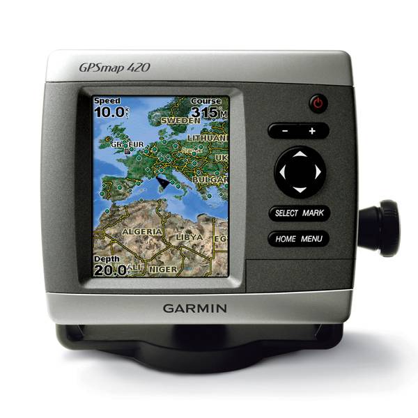
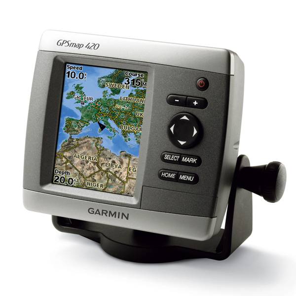
GARMIN Gpsmap 420


GSD 21 Analog Sonar
GSD 22 Digital Sonar


Protective cover
VHF 300i Black


Speed Sensor


P79-6G 200/50KHz 12/45deg plastic adjustable Transducer

P319-6G Nylon 0-8 tilt 50/200 kHz Plastic Transducer

B117 0-8 tilt 50/200 kHz Bronze Transducer 6 pin

B260-6BR 1KW 200/50KHz 6/19deg bronze Transducer


Suggested Maps and Software:
 | Inland Lakes |
 | BlueChart g2, g3 Vision |
 | BlueChart g2, g3 on micro SD card with adapter |
 | Garmin Extras |
 | LakeVu HD |
Contents of the package
- GPSMAP 420
- Tilt/swivel mount
- Protective front cover
- Power/data cable
- Owner's manual
Features
GPSMAP 420 features an ultra-bright 4 QVGA display; built-in, satellite-enhanced worldwide basemap and simplified user operation. It has an SD card slot slot so you can add more features with the optional BlueChart g2 Vision card.
The 420s basemap contains worldwide satellite images instead of more traditional maps, and mor maps can be added using SD card without connecting to a computer.
The GPSMAP 420 is also CANet compatible, so you can share sounder data with another chartplotter on your boat.
With the optional BlueChart g2 Vision SD card, you can add a more features to your chartplotter.
3D mariners eye view or fish eye view provides you with a 3-dimensional perspective of map information, above the waterline and below it.
High-resolution satellite images and aerial photographs.
Auto Guidance technology can create a route you can actually follow one that avoids obstacles, shallow water, buoys and other obstructions.


Specifications
Physical & Performance:
Unit dimensions, WxHxD: 5.7" x 5.0" x 2.7" (14.5 x 12.7 x 6.9 cm)
Display size, WxH: 2.4" x 3.2", 4.0" diagonal (6.1 x 8.1 cm, 10.2 cm diagonal)
Display resolution, WxH: 240 x 320 pixels
Display type: QVGA display
Weight: 1.3 lb (590 g)
Battery: none
Battery life: none
Waterproof: yes (IPX7)
Antenna: internal
NMEA input/output: NMEA 0183
Maps & Memory:
Basemap: yes
Preloaded maps: no
Ability to add maps: yes
Built-in memory: none (cannot load maps to internal memory)
Accepts data cards: SD card slot
Waypoints/favorites/locations: 1,500
Routes: 20
Track log: 10,000 points; 20 saved tracks
Features:
Garmin radar compatible: no
Garmin sonar compatible: yes
CANet® compatible: yes
Garmin Marine Network compatible: no
Touchscreen: no
Supports AIS (tracks target ships' position): yes
Supports DSC (displays position data from DSC capable VHF radio): yes
Audible alarms: yes
Tide tables: yes
Hunt/fish calendar: no
Sun and moon information: yes
3-D map view: yes (with optional BlueChart g2 Vision card)
Auto Guidance: yes (with optional BlueChart g2 Vision card)
Automatic routing (turn by turn routing on roads): no
XM WX Weather & Radio for U.S. compatible: no
Voice prompts (e.g. "Turn right in 500 ft."): no
Speaks street names (e.g. "Turn right ON ELM STREET in 500 ft."): no
Remote control: no
Headphone jack/audio line-out: no
Audio/video input/output: no
Portable: no
Automotive/motorcycle-friendly: no
Item number: 010-00515-20
UPC: -
Package weight: 5 lb
Following reviews were written by actual customers.
Every GPS4US customer has a chance to live a feedback after receiving a product.
 by Janos K, , 3/7/2011
ok.thank .but in post slow in Hungary
Other Products in the Series:
| GARMIN Gpsmap 420 | Add to comparison |
| GARMIN GPSMAP 420s no transducer | |
| GARMIN GPSMAP 420s with transducer | |
| GARMIN GPSMAP 420s with transducer NOH | |
| GARMIN Gpsmap 421 | Add to comparison |
| GARMIN Gpsmap 421 NOH | |
| GARMIN GPSMAP 421s no transducer | Add to comparison |
| GARMIN GPSMAP 421s with transducer | Add to comparison |
| GARMIN GPSMAP 421s with transducer NOH | |
| GARMIN Gpsmap 430 NOH | |
| GARMIN Gpsmap 430 | |
| GARMIN GPSMAP 430s with transducer | |
| GARMIN GPSMAP 430s with transducer NOH | |
| GARMIN Gpsmap 431 NOH | |
| GARMIN Gpsmap 431 | Add to comparison |
| GARMIN GPSMAP 431s with transducer | Add to comparison |
| GARMIN GPSMAP 431s with US Lake maps and transducer NOH | |
| GARMIN GPSMAP 431s with US Lake maps, without transducer NOH | |
| GARMIN Gpsmap 440 | |
| GARMIN Gpsmap 440 NOH | |
| GARMIN GPSMAP 440s no transducer | |
| GARMIN GPSMAP 440s with transducer | |
| GARMIN GPSMAP 440s with transducer NOH | |
| GARMIN Gpsmap 441 | Add to comparison |
| GARMIN GPSMAP 441s no transducer | Add to comparison |
| GARMIN GPSMAP 441s with transducer | Add to comparison |
| GARMIN Gpsmap 520 NOH | |
| GARMIN Gpsmap 520 | |
| GARMIN GPSMAP 520s no transducer | |
| GARMIN GPSMAP 520s no transducer NOH | |
| GARMIN GPSMAP 520s with transducer | |
| GARMIN GPSMAP 520s with transducer NOH | |
| GARMIN Gpsmap 521 | Add to comparison |
| GARMIN Gpsmap 521 NOH | |
| GARMIN GPSMAP 521s no transducer | Add to comparison |
| GARMIN GPSMAP 521s with transducer | Add to comparison |
| GARMIN Gpsmap 525 NOH | |
| GARMIN Gpsmap 525 | |
| GARMIN GPSMAP 525s no transducer NOH | |
| GARMIN GPSMAP 525s no transducer | Add to comparison |
| GARMIN GPSMAP 525s with transducer | Add to comparison |
| GARMIN GPSMAP 525s with transducer NOH | |
| GARMIN Gpsmap 526 | Add to comparison |
| GARMIN Gpsmap 526 NOH | |
| GARMIN GPSMAP 526s no transducer NOH | |
| GARMIN GPSMAP 526s no transducer | Add to comparison |
| GARMIN GPSMAP 526s with transducer | Add to comparison |
| GARMIN GPSMAP 526s with transducer NOH | |
| GARMIN Gpsmap 527 | Add to comparison |
| GARMIN GPSMAP 527xs with Canada LakeVu HD and without transducer | Add to comparison |
| GARMIN GPSMAP 527xs with transducer | Add to comparison |
| GARMIN GPSMAP 527xs without transducer | Add to comparison |
| GARMIN Gpsmap 530 | |
| GARMIN Gpsmap 530 NOH | |
| GARMIN GPSMAP 530s with transducer | |
| GARMIN Gpsmap 531 | Add to comparison |
| GARMIN Gpsmap 531 NOH | |
| GARMIN GPSMAP 531s with transducer NOH | |
| GARMIN GPSMAP 531s with transducer | Add to comparison |
| GARMIN GPSMAP 531s without transducer NOH | |
| GARMIN Gpsmap 535 NOH | |
| GARMIN Gpsmap 535 | |
| GARMIN GPSMAP 535s with transducer | |
| GARMIN GPSMAP 535s with transducer NOH | |
| GARMIN GPSMAP 535s without transducer NOH | |
| GARMIN Gpsmap 536 | Add to comparison |
| GARMIN GPSMAP 536s with transducer | Add to comparison |
| GARMIN Gpsmap 540 | |
| GARMIN GPSMAP 540s no transducer | |
| GARMIN GPSMAP 540s with transducer | |
| GARMIN Gpsmap 541 | Add to comparison |
| GARMIN GPSMAP 541s no transducer | Add to comparison |
| GARMIN GPSMAP 541s with transducer | Add to comparison |
| GARMIN Gpsmap 545 | |
| GARMIN Gpsmap 545 NOH | |
| GARMIN GPSMAP 545s no transducer | Add to comparison |
| GARMIN GPSMAP 545s with transducer | Add to comparison |
| GARMIN GPSMAP 545s with transducer NOH | |
| GARMIN GPSMAP 545s without transducer NOH | |
| GARMIN Gpsmap 546 | Add to comparison |
| GARMIN Gpsmap 546 NOH | |
| GARMIN GPSMAP 546s no transducer NOH | |
| GARMIN GPSMAP 546s no transducer | Add to comparison |
| GARMIN GPSMAP 546s with transducer | Add to comparison |
| GARMIN GPSMAP 546s with transducer NOH | |
| GARMIN Gpsmap 547 | Add to comparison |
| GARMIN GPSMAP 547xs with transducer | Add to comparison |
| GARMIN GPSMAP 547xs without transducer | Add to comparison |
| GARMIN Gpsmap 550 | |
| GARMIN GPSMAP 550s no transducer | |
| GARMIN Gpsmap 555 | |
| GARMIN GPSMAP 555s no transducer - UK | |
| GARMIN GPSMAP 555s with transducer - AUS |