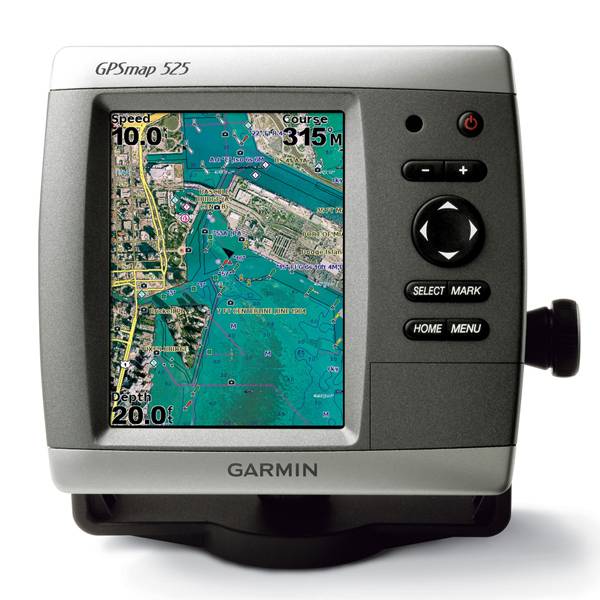
GARMIN Gpsmap 525


GSD 21 Analog Sonar
GSD 22 Digital Sonar


Protective cover (replacement)


Flush mounting kit


Speed Sensor

Gmi 10

P79-6G 200/50KHz 12/45deg plastic adjustable Transducer

B164 1kW 20 tilt 50/200 kHz bronze Transducer 6 pin

P319-6G Nylon 0-8 tilt 50/200 kHz Plastic Transducer

B117 0-8 tilt 50/200 kHz Bronze Transducer 6 pin

B258-6g 1kW 50/200 kHz thru-hull 6 pin transducer

B260-6BR 1KW 200/50KHz 6/19deg bronze Transducer


Suggested Maps and Software:
 | Inland Lakes |
 | BlueChart g2, g3 Vision |
 | BlueChart g2, g3 on micro SD card with adapter |
 | Garmin Extras |
 | LakeVu HD |
Contents of the package
Features
The GPSMAP 525 may be a slim chartplotter, but it gives you a vivid, colorful arrayof graphics on a roomy 5-inch VGA display. It comes with a built-in worldwide basemap
that brings you realistic satellite imagery that pops off the screen. Plus, with the
SD card slot, you can easily add your own maps without any problem. And if you want
to know where youre going, the GPSMAP 525s user-friendly interface makes navigation
a breeze.
Further, your GPSMAP 525 is CANet compatible, which means you can share sounder data
with another chartplotter on your boat. And the optional BlueChart g2 Vision SD card
allows you to customize your features with 3D Mariners and Fish eye view to see both
above and below the waterline, high resolution satellite images and aerial
photographs, and Auto Guidance technology.


Specifications
Physical & Performance:
Unit dimensions, WxHxD: 5.9" x 6.4" x 2.9" (15.0 x 16.3 x 7.4 cm)
Display size, WxH: 3.0" x 4.0", 5.0" diagonal (7.6 x 10.2 cm, 12.7 cm diagonal)
Display resolution, WxH: 480 x 640 pixels
Display type: VGA display
Weight: less than 1.75 lb (0.8 kg)
Battery: none
Battery life: none
Waterproof: yes (IPX7)
Antenna: internal
NMEA input/output: NMEA 0183
Maps & Memory:
Basemap: yes
Preloaded maps: no
Ability to add maps: yes
Built-in memory: none (cannot load maps to internal memory)
Accepts data cards: SD card slot
Waypoints/favorites/locations: 1,500
Routes: 20
Track log: 10,000 points; 20 saved tracks
Features:
Garmin radar compatible: no
Garmin sonar compatible: yes
CANet® compatible: yes
Garmin Marine Network compatible: no
Touchscreen: no
Supports AIS (tracks target ships' position): yes
Supports DSC (displays position data from DSC capable VHF radio): yes
Audible alarms: yes
Tide tables: yes
Hunt/fish calendar: no
Sun and moon information: yes
3-D map view: yes (with optional BlueChart g2 Vision card)
Auto Guidance: yes (with optional BlueChart g2 Vision card)
Automatic routing (turn by turn routing on roads): no
XM WX Weather & Radio for U.S. compatible: no
Voice prompts (e.g. "Turn right in 500 ft."): no
Speaks street names (e.g. "Turn right ON ELM STREET in 500 ft."): no
Remote control: no
Headphone jack/audio line-out: no
Audio/video input/output: no
Portable: no
Automotive/motorcycle-friendly: no
Item number: 010-00597-00
UPC: 753759074722
Package weight: 6 lb
Following reviews were written by actual customers.
Every GPS4US customer has a chance to live a feedback after receiving a product.
 by Dasmiel B, , 7/13/2012
Good item
by Per S, , 6/20/2012Perfect! +++++
by rolando S, , 12/21/2011good
by Daniel C, , 4/22/2011Excellent!! Looks and works as brand new! Nice to be able to actually talk by phone to "live" helpful people at GPS4US...They were great! The Garmin 525 has a much Sharper and Clearer screen display than the older 520 model...
by Pannier D, , 4/22/2011C''est un très bon produit
by Cathy G, , 4/2/2011Very nice
by Lennart R, , 3/16/2011I have only used the 525 indoors at home trying to find out how it works, waiting for the ice to disappear. I have done som rutes that I will use this summer. I think its a very logic and funtional GPS. I have a G2-Vision which are a perfect chart. I''m looking forward to use it during the sailing trips this summer. Best Regards Lennart Rundqvist Sweden
Other Products in the Series:
| GARMIN Gpsmap 420 | Add to comparison |
| GARMIN Gpsmap 420 NOH | |
| GARMIN GPSMAP 420s no transducer | |
| GARMIN GPSMAP 420s with transducer | |
| GARMIN GPSMAP 420s with transducer NOH | |
| GARMIN Gpsmap 421 | Add to comparison |
| GARMIN Gpsmap 421 NOH | |
| GARMIN GPSMAP 421s no transducer | Add to comparison |
| GARMIN GPSMAP 421s with transducer | Add to comparison |
| GARMIN GPSMAP 421s with transducer NOH | |
| GARMIN Gpsmap 430 NOH | |
| GARMIN Gpsmap 430 | |
| GARMIN GPSMAP 430s with transducer | |
| GARMIN GPSMAP 430s with transducer NOH | |
| GARMIN Gpsmap 431 | Add to comparison |
| GARMIN Gpsmap 431 NOH | |
| GARMIN GPSMAP 431s with transducer | Add to comparison |
| GARMIN GPSMAP 431s with US Lake maps and transducer NOH | |
| GARMIN GPSMAP 431s with US Lake maps, without transducer NOH | |
| GARMIN Gpsmap 440 | |
| GARMIN Gpsmap 440 NOH | |
| GARMIN GPSMAP 440s no transducer | |
| GARMIN GPSMAP 440s with transducer | |
| GARMIN GPSMAP 440s with transducer NOH | |
| GARMIN Gpsmap 441 | Add to comparison |
| GARMIN GPSMAP 441s no transducer | Add to comparison |
| GARMIN GPSMAP 441s with transducer | Add to comparison |
| GARMIN Gpsmap 520 NOH | |
| GARMIN Gpsmap 520 | |
| GARMIN GPSMAP 520s no transducer | |
| GARMIN GPSMAP 520s no transducer NOH | |
| GARMIN GPSMAP 520s with transducer | |
| GARMIN GPSMAP 520s with transducer NOH | |
| GARMIN Gpsmap 521 | Add to comparison |
| GARMIN Gpsmap 521 NOH | |
| GARMIN GPSMAP 521s no transducer | Add to comparison |
| GARMIN GPSMAP 521s with transducer | Add to comparison |
| GARMIN Gpsmap 525 | |
| GARMIN GPSMAP 525s no transducer NOH | |
| GARMIN GPSMAP 525s no transducer | Add to comparison |
| GARMIN GPSMAP 525s with transducer | Add to comparison |
| GARMIN GPSMAP 525s with transducer NOH | |
| GARMIN Gpsmap 526 | Add to comparison |
| GARMIN Gpsmap 526 NOH | |
| GARMIN GPSMAP 526s no transducer NOH | |
| GARMIN GPSMAP 526s no transducer | Add to comparison |
| GARMIN GPSMAP 526s with transducer | Add to comparison |
| GARMIN GPSMAP 526s with transducer NOH | |
| GARMIN Gpsmap 527 | Add to comparison |
| GARMIN GPSMAP 527xs with Canada LakeVu HD and without transducer | Add to comparison |
| GARMIN GPSMAP 527xs with transducer | Add to comparison |
| GARMIN GPSMAP 527xs without transducer | Add to comparison |
| GARMIN Gpsmap 530 | |
| GARMIN Gpsmap 530 NOH | |
| GARMIN GPSMAP 530s with transducer | |
| GARMIN Gpsmap 531 | Add to comparison |
| GARMIN Gpsmap 531 NOH | |
| GARMIN GPSMAP 531s with transducer NOH | |
| GARMIN GPSMAP 531s with transducer | Add to comparison |
| GARMIN GPSMAP 531s without transducer NOH | |
| GARMIN Gpsmap 535 NOH | |
| GARMIN Gpsmap 535 | |
| GARMIN GPSMAP 535s with transducer | |
| GARMIN GPSMAP 535s with transducer NOH | |
| GARMIN GPSMAP 535s without transducer NOH | |
| GARMIN Gpsmap 536 | Add to comparison |
| GARMIN GPSMAP 536s with transducer | Add to comparison |
| GARMIN Gpsmap 540 | |
| GARMIN GPSMAP 540s no transducer | |
| GARMIN GPSMAP 540s with transducer | |
| GARMIN Gpsmap 541 | Add to comparison |
| GARMIN GPSMAP 541s no transducer | Add to comparison |
| GARMIN GPSMAP 541s with transducer | Add to comparison |
| GARMIN Gpsmap 545 | |
| GARMIN Gpsmap 545 NOH | |
| GARMIN GPSMAP 545s no transducer | Add to comparison |
| GARMIN GPSMAP 545s with transducer | Add to comparison |
| GARMIN GPSMAP 545s with transducer NOH | |
| GARMIN GPSMAP 545s without transducer NOH | |
| GARMIN Gpsmap 546 | Add to comparison |
| GARMIN Gpsmap 546 NOH | |
| GARMIN GPSMAP 546s no transducer NOH | |
| GARMIN GPSMAP 546s no transducer | Add to comparison |
| GARMIN GPSMAP 546s with transducer | Add to comparison |
| GARMIN GPSMAP 546s with transducer NOH | |
| GARMIN Gpsmap 547 | Add to comparison |
| GARMIN GPSMAP 547xs with transducer | Add to comparison |
| GARMIN GPSMAP 547xs without transducer | Add to comparison |
| GARMIN Gpsmap 550 | |
| GARMIN GPSMAP 550s no transducer | |
| GARMIN Gpsmap 555 | |
| GARMIN GPSMAP 555s no transducer - UK | |
| GARMIN GPSMAP 555s with transducer - AUS |