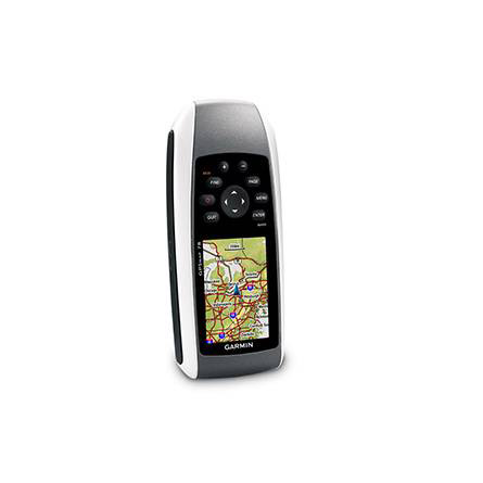
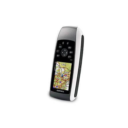
GARMIN Gpsmap 78


GA 30 GPS antenna (GA 29 replacement)
GA 27C low-profile remote automobile antenna

GA 25MCX low profile remote GPS antenna


PC interface cable (RS232 serial port connector)


Power/data cable (bare wires)

Serial data/power cable (bare wires)

Heart rate monitor


HRM-Pro Heart Rate Monitor with Bluetooth and Running Dynamics

HRM-Pro Plus Heart Rate Monitor


Cup Holder Universal Mount RAM-A-CAN II with 6 in Flex Arm


Lanyard 17 inch

Lanyard Carabiner

BirdsEye Satellite Imagery Retail Card
BirdsEye Satellite Imagery US and Canada
Suggested Maps and Software:
 | Inland Lakes |
 | BlueChart g2, g3 on micro SD card with adapter |
 | Garmin Street Maps and City Navigation |
 | Garmin Topographic Maps |
 | LakeVu HD |
Contents of the package
Features
When youre on the water, the GPSMAP 78 will help improve your performance. It givesyou crisp, color mapping and a high-sensitivity GPS receiver, along with rubber side
grips and a microSD card slot for loading additional maps.
And it floats, too.
Become an explorer
With the built-in worldwide basemap, you can go anywhere you need to go. And, the
GPSMAP 78 is IPX7 waterproof.
Know where you are
GPSMAP 78 has a high-sensitivity WAAS-enabled GPS receiver and HotFix satellite
prediction to determine your location quickly and accurately, no matter your
surrounding terrain.
Customize your maps
With Garmins collection of detailed topographic, marine and road maps, available on
a microSD card you can easily add and customize your GPSMAP 78s maps. If youre
hitting the water, just insert BlueChart g2 preloaded cards. And if youre preparing
for a road trip, City Navigator NT map data provides turn-by-turn directions. GPSMAP
78 supports subscription-based BirdsEye Satellite Imagery, which integrates satellite
images with your maps. And, GPSMAP 78 is compatible with the free software Custom
Maps, which transforms paper and electronic maps into downloadable files.
All your data in one place
With a connection to your computer and the internet, you can get detailed analysis of
your activities, and send tracks to your outdoor device with Garmin Connect. Youll
get activity tables and a chance to see your activities on a Google Earth map. You
can explore routes uploaded by millions of Garmin Connect users, and share your
experience on Twitter and Facebook.
A geocachers dream
Your GPSMAP 78 can download geocaching GPX files. Your device stores and displays key
details, including terrain, location, difficulty, hints and descriptions. You wont
need any more printouts or manually-entered coordinates. Just upload the GPX file to
your unit and start hunting.
Specifications
Installed languages: English,
Spanish, French, Deutsch, Italiano, Portugues, Cesky, Dansk,
Nederlands, Norsk, Suomi, Hrvatski, Magyar, Polski, Russian, Svenska,
Turkse, Latvian, Slovak, Slovenian, Greek, Arabic, Farsi, Bulgarian.
More languages may be available through Garmin web updater.
Physical & Performance:
Unit dimensions, WxHxD: 2.6" x 6.0" x 1.2" (6.6 x 15.2 x 3.0 cm)
Display size, WxH: 1.6" x 2.2" (4.1 x 5.6 cm); 2.6" diag (6.6 cm)
Display resolution, WxH: 160 x 240 pixels
Display type: transflective, 65-K color TFT
Weight: 7.7 oz (218.3 g) with batteries
Battery: 2 AA batteries (not included); NiMH or Lithium recommended
Battery life: 20 hours
Waterproof: yes (IPX7)
Floats: yes
High-sensitivity receiver: yes
Interface: USB and NMEA 0183 compatible
Maps & Memory:
Basemap: yes
Ability to add maps: yes
Built-in memory: 1.7 GB
Accepts data cards: microSD card (not included)
Waypoints/favorites/locations: 2000
Routes: 200
Track log: 10,000 points, 200 saved tracks
Features:
Automatic routing (turn by turn routing on roads): yes (with optional mapping for detailed roads)
Electronic compass: no
Touchscreen: no
Barometric altimeter: no
Camera: no
Geocaching-friendly: yes (paperless)
Custom maps compatible: yes
Photo navigation (navigate to geotagged photos): yes
Outdoor GPS games: no
Hunt/fish calendar: yes
Sun and moon information: yes
Tide tables: yes
Area calculation: yes
Custom POIs (ability to add additional points of interest): yes
Unit-to-unit transfer (shares data wirelessly with similar units): no
Picture viewer: no
Garmin Connect compatible (online community where you analyze, categorize and share data): yes
Item number: 010-00864-00
UPC: -
Package weight: 2 lb
Following reviews were written by actual customers.
Every GPS4US customer has a chance to live a feedback after receiving a product.
 by Galin P, , 1/9/2012
gpsmap 78 is built to last, a good balance of the simplicity and convenience, it is really rugged and yes it floats, it came with worldwide base map, just added more maps from microSD card and now ready for kayaking, fishing and geocaching
by RODRIGO C, , 11/13/2011is great
 by galves J, , 10/28/2011
bon gps
by pedro O, , 10/9/2011arrived on time, good prices, good service.
by Mikhail B, , 9/8/2011For what you get, this model is very simple to use, simple to get your data out and put in other forms. While not used in a maritime setting, we do cross streams, and wander down by the riverside....so the floating is nice.