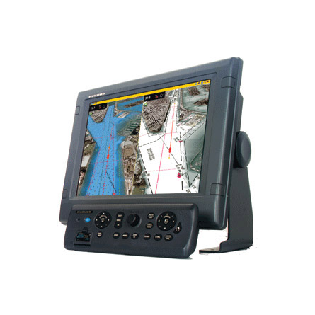
FURUNO MFD8 Chartplotter

This item is brand new
$2,619.95
This item ships within 9 days
|cw


GP330B GPS/WAAS Sensor f NMEA2000


Display Adapter Cable

DVI-D 5M Cable f/NavNet 3D


Lan Cbl 3M Mfd8 12 Water Proof


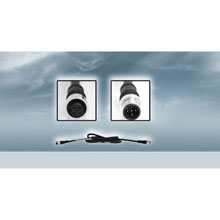
Cable, NMEA2K Micro 1M double-ended


NavNet 3D HUB101

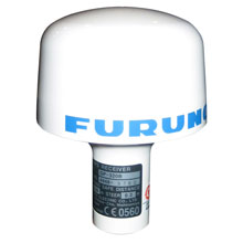
NavNet WAAS/GPS Antenna w/ NMEA0183

DFF1 Digital(FDF) BLACK BOX Echosounder Module f/NavNet

DFF3 Black Box Sounder Module

DFF1-UHD TruEcho CHIRP Sounder Module
FA30 Black Box AIS Receiver

FI-507 Multi XL Display


MaxSea TimeZero Explorer Marine Software
FA50 Class B AIS

NavNet 3D 4kW 3.5 ft Ultra High Definition Digital Radar

DRS4D 4kW Ultra High Definition Digital Radar

NavNet 3D 12kW Ultra High Definition Digital Radar less Antenna

NavNet 3D 25kW Ultra High Definition Digital Radar less Antenna

DRS2D 2kW Ultra High Definition Digital Radar

NavNet 3D 6kW 4 ft Ultra High Definition Digital Radar


DST-800PSF Smart Sensor


Bronze Thru-Hull, Digital Depth, Speed and Temp Sensor, NMEA2000


PB150 Ultrasonic WeatherStatio


SC110 PowerTower Port Mounted Light Bar
SC30 Satellite Compass w/o Display

SC50 Satellite Compass
Contents of the package
Features
The world of onboard navigation systems has evolved. Furunos dedication to deliver the best marine electronics has led to the most innovative, powerful solution for onboard navigation ever.Furunos NavNet 3D is a groundbreaking new navigation system that breathes new life into the user interface. Once you start using NavNet 3D, you will be amazed at how a system so powerful can be so simple to use. NavNet 3D comes fully loaded with groundbreaking new features that will expand your navigational horizons.
NavNet 3D uses a cutting-edge technology weve named Time Zero. Time Zero facilitates instant chart redraw, allowing for zooming in and out, changing chart display modes and other chart handling functions seamlessly and with no lag at all. Time Zero brings you a truly seamless navigation environment you have to experience to believe.
True 3D environment for a more instinctive chart presentation.
NavNet 3D incorporates a whole new dimension into chart presentation with Full Time 3D chart rendering. You can choose a 2D top-down view of the navigation chart for a look and feel that duplicates a traditional chart plotting presentation. Or, you can choose to pan and zoom the chart to any angle at any range scale you choose instantly. There is no 3D mode to change into and no waiting at all, because NavNet 3D operates in this 3D environment full time. This variety of chart presentations helps to improve your situational awareness by giving you unprecedented control over your charting environment.
NavNet 3Ds powerful new graphic engine brings new chart presentation options to the conventional 2D method of chart plotting. Satellite Photo Fusion is a powerful new tool, a hybrid blend of detailed satellite imagery and critical chart data. These new presentation options allow you to visually grasp your exact position in a way that was never before possible.
NavNet 3D incorporates native 3D chart architecture that allows for a full-time 3-dimensional presentation, as opposed to 2D charts that require special effects to appear 3D. There are no special modes; that limit your ability to navigate the way you want. With NavNet 3Ds true 3D environment, you can see all of the information you want with no limitations on what information you wish to view. Plan your routes and enter waypoints directly on your raster or vector native 3D charts. Radar overlay, Sirius Network Weather Receiver, AIS, plus all of your chart symbols and depth soundings; any and all of this information can be displayed at will. This is the beauty of navigating in true 3D. You have full control over the presentation all of the time.
Chart Options.
NavNet 3D is the only Chart Plotter on the market that allows you choose the type of charts you want to use. Your system comes preloaded with all currently available NOAA Vector (computer generated) and Raster (scanned paper charts) that are converted into the NavNet 3D MM3D format. You also have the option to purchase C-MAP by Jeppesen Vector charts that have been converted to the MM3D format. These C-MAP by Jeppesen charts are comprised of the same cartographic chart information found in Jeppesens C-MAP MAX and C-MAP MAX PRO charts. For certain parts of the world, you can purchase Datacore by Navionics Vector charts that are based on Navionics Gold cartographic chart information. Finally, there are free Fishing Charts for the US that are preloaded on each NavNet 3D system that give you detailed NOAA bathymetric data for a variety of fishing hot spots.
Satellite Photo Fusion.
Satellite photography can be fused with raster or vector chart information. Land areas (zero depth) are completely opaque, so that these areas are displayed as satellite photos on the chart. As the depth increases, the satellite photography becomes more transparent so that you will know where the shallows end and the deeper water starts.
High resolution satellite photography aids in seabed classification so that you will be able to easily identify areas of sand, rock, coral or other obstructions.
Time Zero Technology Makes Chart Redraw A Thing Of The Past
High-speed processing and a powerful graphic engine deliver Time Zero technology instant, seamless chart handling with no lag or loading time. NavNet 3D Time Zero technology redefines the meaning of stress-free operation. Zoom seamlessly and continuously to whatever chart scale you desire. Instead of limiting you to a small handful of chart scales to choose from, Time Zero architecture allows you to zoom in or out to the exact magnification level you like without steps or limitations.
You can freely pan and scroll the chart by simply pressing the scroll pad. This gives you freedom to explore the chart data, allowing you to focus on a specific area ahead of or around your vessel without losing track of your position on the chart. Explore the chart data at your leisure, and then instantly return to your own ship at the touch of a single dedicated button.
FURUNO NavNet 3D Digital Solution sets a new standard.
NavNet 3D operates in a fully digital environment with its highly sensitive digital sensors for radar and fish finder. The operating structure is also digitized, delivering total fusion of hardware and software modules in its operating scheme.
NavNet 3D integrates Ultra High Definition (UHD) Digital Radar that facilitates fully automatic, high-precision Gain, Sea/Rain Clutter and Tuning control for hands-free operation and ultimate performance. UHD offers crystal clear, noise-free target presentation with automatic real-time digital signal processing. Antenna rotation speed (24/36/48 rpm) is automatically shifted appropriate to the pulse length. Commercial-grade radar performance is now available in the ultimate MFD navigation suite. One of the amazing features of Furuno UHD Digital Radar is Real Time dual range radar display, which scans and displays two different radar ranges with no lag at all. This greatly enhances your situational awareness.
You probably know about digital fish finders, but are not quite sure what the term really means. FURUNO Digital Filter fish finders feature advanced filtering capabilities and digital auto tuning which eliminate noise and deliver the ability to spot individual fish with clarity, accuracy and detail.
NavNet 3D ROTOKEY Puts a whole new spin in User Friendly.
NavNet 3D challenges the conventional menu operating system with a whole new concept, the ROTOKEY on-screen revolving menu key. One turn of the Rotokey gives you instant access to full control of NavNet 3D. The Rotokey is designed as a part of NavNet 3Ds scalable operating system; a short press of the Rotokey gives you access to a user-selected set of the basic functions that you will use the most, while a longer press of the key displays all of the functions available. Never leave your navigation screen to enter a menu again!
NavNet 3D provides the easiest user interface on the market with a combination of both Rotokey and familiar point-and-click cursor pad controls. The power of the point-and-click interface allows for incredibly simple operation click anywhere on the screen for context-sensitive options for that area. Click on any data box to access detailed information for that function. You can also connect a generic USB mouse to further simplify operation.
One press of the DISP button allows you to easily select the presentation you desire. Five intelligently designed hot-pages are available to you right out of the box, with the ability to save up to ten custom layouts.
The scrolling pad allows independent scrolling and panning capabilities from a dedicated omni-pad. Pan the chart and shift the radar without any screen redraw or lag. You can also control IP cameras without accessing complicated menus or changing your current presentation.
One long press of the 3D key will toggle the chart from 3D to a familiar 2D, top-down perspective. While the chart remains in its native 3D environment, only the perspective shifts there is no special mode required to shift back to 3D perspective
Specifications
Chart scaling without limitation
- Pre-loaded with NOAA raster chart library for entire U.S. coastline including Alaska and Hawaii
- TimeZero technology facilitates instant chart redraw, allowing zooming in and out, chart panning, changing chart display modes and other chart handling functions seamlessly and with no lag time
- Full Time 3D chart rendering. Choose a 2D top-down view of the navigation chart for a traditional chart plotting presentation, or choose to pan and zoom the chart to any angle at any range scale you choose
- Pan the chart using the scroll pad, and then instantly return to own ship at the touch of a single dedicated key
- Zoom seamlessly and continuously to whatever chart scale you desire - TimeZero architecture allows you to seamlessly zoom in or out to the exact magnification level you like without steps or limitations
- No 3D mode to change into and no waiting - NavNet 3D operates in a 3D environment full-time
- Fuse satellite photography with raster or vector chart information. Land areas (zero depth) are completely opaque, so that these areas are displayed as high-resolution satellite photos on the chart. As the depth increases, the satellite photography becomes more transparent so that you will know where the shallows end and the deeper water starts, while allowing the raster or vector chart to be visible
- More than 12,000 ship's track points and over 2,000 waypoints
- 200 planned routes, with up to 100 waypoints/route
- Preloaded tides & currents
- Engine monitoring
- Built-in ARPA processor can simultaneously acquire and track up to 30 targets (with appropriate sensor)
- AIS tracking when connected to AIS receiver
- True color depth shading utilizing bathymetric data
- Standard video input and outputs
Network Sensor connection from Radar
- All NavNet 3D radar sensors incorporate a Network port to which certain Furuno sensors can be directly connected
- Power for Furuno network sensors is supplied directly from the radar, allowing for flexible installation of multiple sensors without the need to run cables to the main processor unit
- Data from Furuno network sensors is converted and distributed throughout the NavNet 3D Ethernet network
Easiest user interface on the market
- Simple operation with a combination of both RotoKey and a familiar point-and-click cursor pad control
- By turning a rotary knob on the control panel, RotoKey will be activated, giving you full access to NavNet 3D controls
- A short press of the RotoKey gives you access to a user-selected set of the functions that you select upon installation from Basic, Standard, Full or Custom, while a longer press of the key displays all of the functions available
- The power of the point-and-click interface allows for incredibly simple operation - click anywhere on the screen for context-sensitive options for that area. Click on any data box to access detailed information for that function. A variety of features can be accessed through a familiar left or right click interface
- Connect a generic USB mouse to further simplify operation
Fully digitized environment with add-on components
- Highly sensitive digital sensors for radar and fish finder, delivering total fusion of hardware and software
- Ultra High Definition (UHD) Digital Radar offers crystal clear, noise-free target presentation with automatic real-time digital signal processing
- Real-time digital auto Gain/Sea/Rain controls to deliver noise-free radar presentation
- Radar antenna rotation speed (24/36/48 rpm) is automatically shifted to the appropriate pulse length
- Simultaneous scanning technology drives our powerful dual-range radar, providing unsurpassed target detection. With each sweep of antenna, dual progressive scan transmissions are sent, received and processed to display two separate radar ranges on your NavNet 3D display simultaneously. Each radar presentation acts autonomously, allowing for manipulation of individual gain and clutter controls
- Sirius Satellite Weather overlays chart with highly accurate information, requires Sirius receiver and subscription
- Optional Weatherfax/Navtex receiver available
- External alarm output & point/MOB alert input
- Control up to 4 AXIS IP cameras
Power Requirements
- 12-24 VDC
Item number: MFD8
UPC: 611679313485
Package weight: 23 lb
Other Products in the Series:
 | FURUNO MFD12 Chartplotter | Add to comparison |
 | FURUNO MFDBB Chartplotter | Add to comparison |