GARMIN Astro 900 T9 Orange Dog Tracking Bundle T 9 for US and Canada


Item: 010-02053-00
This item is brand new
$649.99
This item ships within 1 day


This item is brand new
$649.99
This item ships within 1 day
Adapters Chargers


Antennas


010-12821-00
VHF antenna for Astro 900
VHF antenna for Astro 900
Out of stock

010-12821-01
VHF Antenna for T 9 Dog Device
VHF Antenna for T 9 Dog Device
Out of stock


Cables


Cases and Covers


010-11828-02
Field Bag
Field Bag
No Longer Available


011-02602-CG
Gasket Seal for Astro casing
Gasket Seal for Astro casing
No Longer Available


Fitness
010-10997-00
Heart rate monitor
Heart rate monitor
No Longer Available

010-10997-02
Premium Heart rate monitor Soft Strap
Premium Heart rate monitor Soft Strap
Out of stock


010-12955-00
HRM-Pro Heart Rate Monitor with Bluetooth and Running Dynamics
HRM-Pro Heart Rate Monitor with Bluetooth and Running Dynamics
No Longer Available

010-13118-00
HRM-Pro Plus Heart Rate Monitor
HRM-Pro Plus Heart Rate Monitor
No Longer Available
Kits

Memory


Mounts


RAM Mounts


RAM Mounts Build your own


RAP-299-2U
Cup Holder Universal Mount RAM-A-CAN II with 6 in Flex Arm
Cup Holder Universal Mount RAM-A-CAN II with 6 in Flex Arm
No Longer Available


Straps, Holsters, Clips


013-00052-00
Lanyard 17 inch
Lanyard 17 inch
No Longer Available


010-12668-02
Lanyard Carabiner
Lanyard Carabiner
Out of stock
T 5 Collars

010-02053-10
T 9 Blue GPS Dog Tracking Collar T9 US and Canada
T 9 Blue GPS Dog Tracking Collar T9 US and Canada
No Longer Available
Other

010-11092-20
Chirp Wireless geocaching beacon
Chirp Wireless geocaching beacon
Out of stock

010-11543-00
BirdsEye Satellite Imagery Retail Card
BirdsEye Satellite Imagery Retail Card
No Longer Available
010-01363-01
Virb X
Virb X
Out of stock
010-01363-11
Virb Xe
Virb Xe
No Longer Available
010-01363-11
NOH Virb XE
NOH Virb XE
Out of stock

010-01529-03
VIRB Ultra 30
VIRB Ultra 30
No Longer Available
010-01363-20
VIRB XE Cycling Bundle
VIRB XE Cycling Bundle
No Longer Available
010-01363-40
VIRB XE Auto Racing Bundle
VIRB XE Auto Racing Bundle
No Longer Available
010-01363-30
VIRB XE Aviation Bundle
VIRB XE Aviation Bundle
No Longer Available
010-01088-15
VIRB Elite Camera Dark
VIRB Elite Camera Dark
No Longer Available
010-01088-10
VIRB Elite Camera
VIRB Elite Camera
No Longer Available
010-11753-00
BirdsEye Satellite Imagery US and Canada
BirdsEye Satellite Imagery US and Canada
No Longer Available

010-01696-00
DriveTrack 70LMT
DriveTrack 70LMT
No Longer Available

010-01982-00
DriveTrack 71
DriveTrack 71
Out of stock

010-02133-00
Montana 700
Montana 700
No Longer Available

010-02347-10
Montana 700i
Montana 700i
Out of stock

010-02347-00
Montana 750i
Montana 750i
No Longer Available
Compatible maps
Suggested Maps and Software:
 | Inland Lakes |
 | BlueChart g2, g3 on micro SD card with adapter |
 | Garmin Street Maps and City Navigation |
 | Garmin Topographic Maps |
 | Garmin Extras |
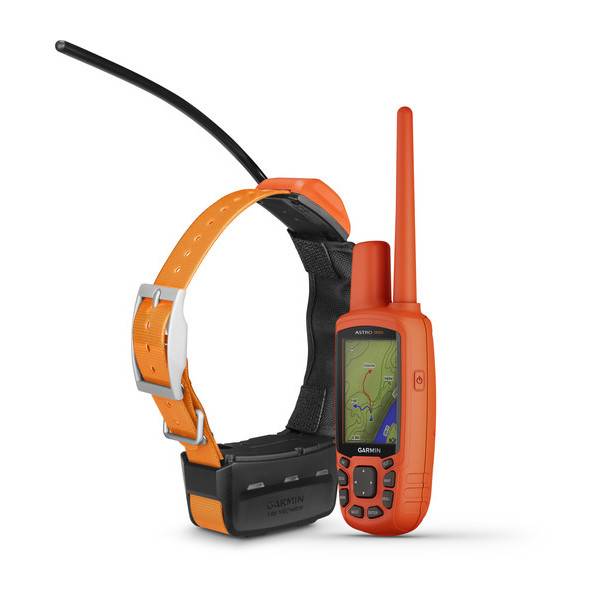
Contents of the package
- Astro 900 handheld
- T 9 dog device with rechargeable lithium-ion battery
- 1 inch (2.5 cm) orange collar strap
- 4.2 inch (10.8 cm) antenna for Astro 900
- 13 inch (33 cm) antenna for T 9
- Belt clip
- AC adapter
- Vehicle power cable
- Charging cable for T 9
- USB cable
- Manual
Features
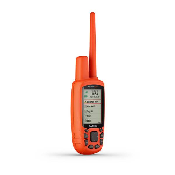
Handheld GPS Sporting Dog Tracking System for U.S. and CanadaTrack up to 20 dogs with the 2.6 color display; pair with T 9 dog devices for a range of up to 5 miles (8 km); uses 900 MHz FHSS, approved for operation in Canada and the U.S.
2.5-second update rate provides faster location tracking when dogs are on the run
High-sensitivity GPS and GLONASS satellite reception has the ability to track in more challenging environments than GPS alone
Preloaded TOPO mapping for the U.S. and southern Canada and a free 1-year BirdsEye Satellite Imagery subscription for better location awareness
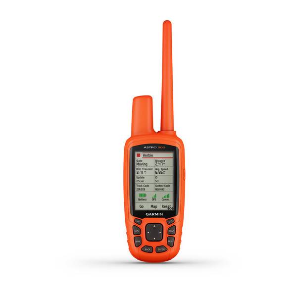
Hunt Metrics dog data analyzes dogs speed, distance traveled and time afield so you can review and train more effectively
With faster 2.5-second location updates and the capacity to follow up to 20 dogs (T 9 devices sold separately or as a bundle), Astro 900 is a handheld powerhouse of dog-tracking performance. Intuitive and easy to use, Astro 900 features a vibrant 2.6 color display, preloaded TOPO mapping for the U.S. and southern Canada, an optional in-unit rechargeable battery and Hunt Metrics data to help analyze your dogs tracking habits in the field, so you can know how to train more effectively.
Follow Your Dog's Every Move
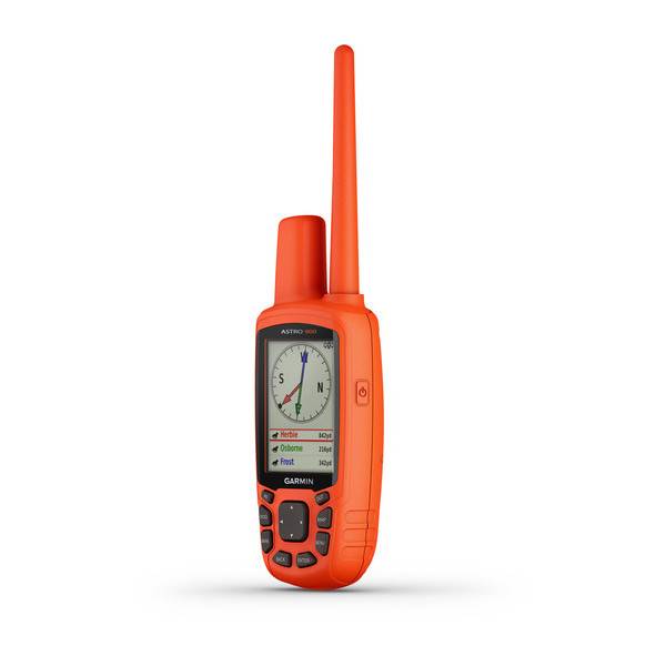
Using our T 9 collar device (sold separately or as a bundle) to transmit each dogs location as often as every 2.5 seconds, Astro 900 is quick to pinpoint the track theyre following even when theyre on the run. On the Astro devices bright, crisp display, you can see your dogs current location and a trail of where hes been. You also can switch over to the Dog Track page to view a compass pointing to your dogs location. For help in keeping the big picture in sight when tracking multiple dogs, its easy to auto zoom the map page, so all dogs can be seen on the display at any time. Dogs that are too far away to fit on the maps current zoom scale can be notated on the displays margin in the direction of the dogs location. To reduce visual clutter on the map, you can toggle between show all, show some and show none selecting the duration that each dogs track is viewable on the display. You can also share a dogs track code so another person can view your dogs location on their units map, along with the dog tracking compass. Further, by sharing a dogs control code, you can allow another person to configure and control your dogs on-collar device.
See More Detail with Additional Mapping
Astro 900 features a microSD card slot that allows you to load even more mapping options. You also can opt for City Navigator® NT map data, which gives you turn-by-turn driving directions on roads. In addition, Astro 900 supports BirdsEye Satellite Imagery (free 1-year subscription included) so you can download satellite images to your device and integrate them with your maps. The Astro devices mapping depicts important nearby geographical features and enables you to see if your dog has crossed a creek or is nearing a dangerous roadway. Astro 900 is also compatible with Garmin Custom Maps, free software that transforms paper and electronic maps into downloadable maps for your device.
Track with Hunt Metrics Dog Data
Sophisticated Hunt Metrics data helps monitor your dogs hunting patterns and behaviors to optimize your training opportunities. You can see your dog's times, distances traveled and overall scores. Plus, Astro 900 will also capture the number of times during the hunt when an on point or treed event was indicated.
Count Your Coveys
After youve tracked down your quarry, mark the exact spot with the Astro devices Covey Counter, a special waypoint that shows the exact location, time of day and elevation where you found your prey as well as the number of birds you flushed and took from that location. Astro lets you save other special waypoints, such as Truck and Lodge, so you can easily find your way back to these locations at the end of the hunt. Astro also offers special waypoint icons to represent food plots, tree stands and other hunting-related points.
Make Every Outing Count
Plan for a more productive hunting trip with BaseCamp, software that lets you view and organize maps, waypoints, routes and tracks. BaseCamp displays topographic map data in 2-D or 3-D on your computer screen, including contour lines and elevation profiles. It also can transfer an unlimited amount of satellite images to your device when paired with your Astro devices free 1-year BirdsEye Satellite Imagery subscription.
Share Wirelessly
With an expanded ecosystem of wireless connectivity options, Astro 900 can support unit-to-unit data transfer with a variety of compatible Garmin devices. For example, Garmin DriveTrack can receive and display dog positions on its moving map with topographic or satellite image views showing navigation cues to your dogs current location. Likewise, a compatible fēnix® GPS watch can receive dog status updates and alerts for viewing at a glance on your wrist. Also, while youre in the field, Astro 900 lets you link and share wirelessly with your buddies compatible devices, such as the Oregon® handheld, Montana® handheld, GPSMAP® 64 chartplotter or other ANT+® connectivity-enabled devices, to help coordinate hunt logistics on the go.
Turn Your Computer Into a BaseStation for Tracking Dogs
Load your laptop with BaseStation software to turn it into a field control center for tracking multiple dogs (equipped with T 9). View real-time GPS information on the larger display of your computer, making it ideal for canine search and rescue teams. And because its GPS and GLONASS capable, you'll get tracking, even where internet and cell phone service isnt available.
Tough, Water-resistant, Long-lasting
Like all Garmin outdoor products, Astro 900 is designed to be effective, easy to use, reliable and rugged enough to withstand all the blows, bumps and sloppy conditions of training and hunting. The handheld unit is water-resistant to IPX7, and it can be powered with standard AA batteries or its optionally available with a long-lasting NiMH battery pack thats rechargeable in the unit. Whats more, if you ever drop or misplace your Astro 900 in the field, the high-visibility orange case makes it easier to track down.
Specifications
Maps & Memory | |
| Ability to add maps | |
|---|---|
| Basemap | |
| Storage and Power Capacity | microSD card (not included) |
| Waypoints/favorites/locations | 2000 |
| Routes | 200 |
| Track log | 10,000 points, 200 saved tracks |
| Preloaded maps | yes (TOPO U.S. and Canada) |
Sensors | |
| Barometric altimeter | |
|---|---|
| Compass | Yes (tilt-compensated 3-axis) |
Outdoor Recreation Features | |
| Area calculation | |
|---|---|
| Automatic routing (turn by turn routing on roads) | Yes (with optional mapping for detailed roads) |
| Geocaching-friendly | Yes (Paperless) |
| Custom maps compatible | |
| Hunt/fish calendar | |
| Sun and moon information | |
Garmin Connect | |
| Garmin Connect compatible (online community where you analyze, categorize and share data) | |
|---|---|
Additional | |
| Additional |
|
|---|---|
General | |
| Physical dimensions | 2.4" x 6.3" x 1.4" (6.1 x 16.0 x 3.6 cm) |
|---|---|
| Weight | 9.2 oz (260.1 g) with batteries |
| Water rating | IPX7 |
| Battery | Optional NiMH pack or 2 standard AA (not included) |
| Display type | transflective, 65-K color TFT |
| Display size | 1.43" x 2.15" (3.6 x 5.5 cm); 2.6" diag (6.6 cm) |
| Display resolution | 160 x 240 pixels |
| Battery life | up to 20 hours (Astro 430) |
| Memory/History | 4 GB |
| High-sensitivity receiver | |
| Interface | USB |
Item number: 010-02053-00
UPC: 753759212735
Package weight: 3 lb
