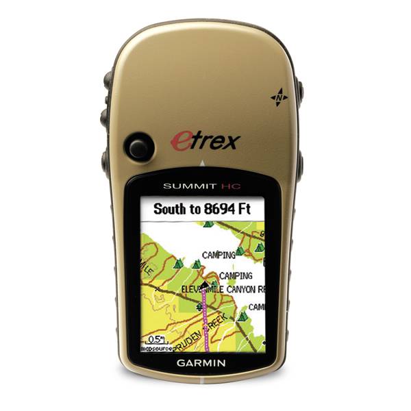
GARMIN ETrex Summit HC


Cup Holder Universal Mount RAM-A-CAN II with 6 in Flex Arm


Lanyard 17 inch

Replacement Mounting Clip

Lanyard Carabiner


Suggested Maps and Software:
 | MetroGuide |
 | Garmin Extras |
 | nuMaps Updates |
Contents of the package
Features
Affordable, versatile, lightweight handheldcompass, altimeter, color screen, high-sensitivity GPS receiver, detailed basemap, 24 MB for optional maps, 14-hour battery life, 176 x 220 pixel display
Specifications
Installed languages: English,
Spanish, French, Deutsch, Italiano, Portugues, Cesky, Dansk,
Nederlands, Norsk, Suomi, Hrvatski, Magyar, Polski, Russian, Svenska,
Turkse, Greek.
More languages may be available through Garmin web updater.
Physical & Performance:
Unit dimensions, WxHxD: 2.2" x 4.2" x 1.2" (5.6 x 10.7 x 3.0 cm)
Display size, WxH: 1.3" x 1.7" (3.3 x 4.3 cm)
Display resolution, WxH: 176 x 220 pixels
Display type: 256 level color TFT
Weight: 5.5 oz (156 g) with batteries
Battery: 2 AA batteries (not included)
Battery life: 14 hours
Waterproof: yes (IPX7)
Floats: no
High-sensitivity receiver: yes
Interface: USB
RoHS version available: yes
Maps & Memory:
Basemap: yes
Preloaded maps: no
Ability to add maps: yes
Built-in memory: 24 MB
Accepts data cards: no
Waypoints/favorites/locations: 500
Routes: 50
Track log: 10,000 points, 10 saved tracks
Features:
Automatic routing (turn by turn routing on roads): no
Electronic compass: yes
Touchscreen: no
Barometric altimeter: yes
Geocaching-friendly: yes
Outdoor GPS games: yes
Hunt/fish calendar: yes
Sun and moon information: yes
Tide tables: no
Area calculation: yes
Custom POIs (ability to add additional points of interest): no
Unit-to-unit transfer (shares data wirelessly with similar units): no
Picture viewer: no
Item number: 010-00633-00
UPC: 753759072919
Package weight: 2 lb
Following reviews were written by actual customers.
Every GPS4US customer has a chance to live a feedback after receiving a product.
 by John S, , 9/21/2012
Fast and clear resolution.
by JOFFRE I, , 9/5/2012GOOD THE PEOPLE LIKES THIS GPS TO WORK
by Denis P, , 8/18/2012It''s great, works well!
by michael S, , 7/12/2012Great GPS, has all the features I need and even some games !
by Jennifer H, , 7/1/2012I purchased 10 units for the organization I work for. I''ve had great success with them. Easy to use, great antenna, good screen size.
 by Yang Sul K, , 5/11/2012
I bought 4 units but only 2 unit is functional. I have to exchange 2 unit
Other Products in the Series: