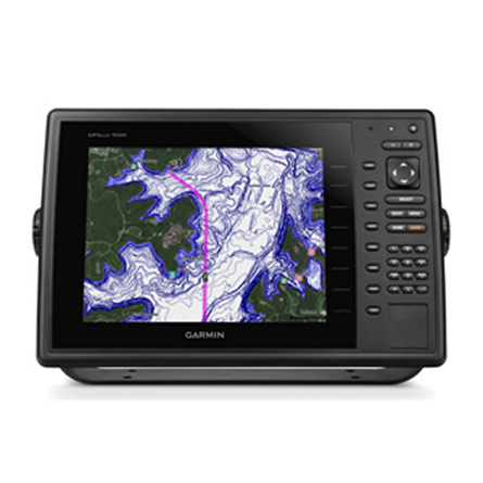
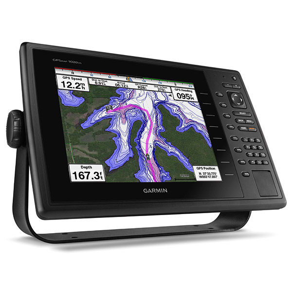
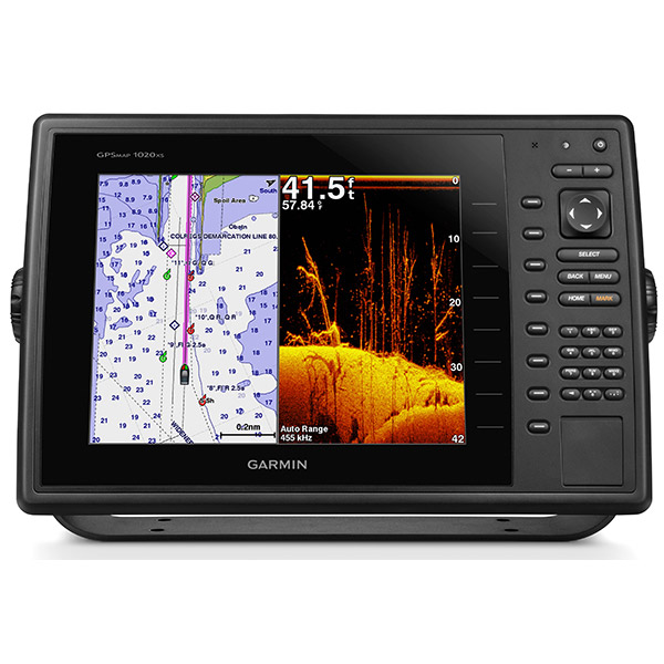
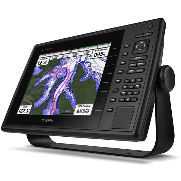
GARMIN GPSMAP 1020xs without Transducer


This item is brand new
$1,680.95
This item ships within 2 days
|cw|sw


GA 30 GPS antenna (GA 29 replacement)

GPS 17x NMEA 2000 GPS Receiver


GXM 52 - SiriusXM Marine Receiver

GDL 40 Weather Receiver

GXM 51 - Weather and Audio XM Receiver

GHP 10 Marine Autopilot System with GHC 20

GHP 10 Marine Autopilot System with GHC 10

GHP 10V Marine Autopilot System with GHC 10

GHP 10V Marine Autopilot System with GHC 20


GHP 12 Sailboat Autopilot System with GHC 10

GHP 20 Marine Autopilot System for Steer-by-Wire with GHC 10

GHP 20 Marine Autopilot System for Viking with GHC 10


GHP 20 Marine Autopilot System for Yamaha Helm Master with GHC 10


GHP 20 Marine Autopilot System with SmartPump and GHC 10


GHP Reactor Hydraulic Autopilot Corepack

GHP Reactor Mechanical Retrofit Solenoid Corepack

GHP Reactor Hydraulic Corepack with SmartPump

GHP Reactor Steer-by-wire Standard Corepack

GHP Reactor Steer-by-wire Corepack for Yamaha Helm Master

GHP Reactor Steer-by-wire Corepack for Viking VIPER

GHP Reactor Steer-by-wire Corepack for Volvo-Penta

GHP Compact Reactor Hydraulic Autopilot Starter Pack


GCV 10 SideVu DownVu CHIRP Scanning Sonar


MotorGuide Adapter Cable 8-pin


Protective cover 1000 Series


Trim Piece Snap Cover 1000 Series

Ais 300

Ais 600

VHF 300 Black

VHF 300 AIS Black

VHF 100 Black
VHF 100i Black

VHF 100 Silver Grey
VHF 100i International

Vhf 110

VHF 200 Black
VHF 200i Black

VHF 200 Silver Gray
VHF 200i International

VHF 210 AIS Marine Radio

VHF 300 Silver Gray
VHF 300i International
VHF 300i Black
VHF 300i AIS Black
VHF 300 AIS Silver Gray
VHF 300i AIS International

BCN weather cap


Bail Mount with Knobs 1000 Series

Flush Mount Kit 1000 Series


Panoptix PS60 Thru-hull Down Transducer

Panoptix PS21 LiveVu Forward Transducer

Panoptix PS21-TM Forward Transom Mount Transducer


GMR 18 xHD Radar


GMR 18 HD Radar

GMR 604 xHD Open Array and Pedestal

GMR 606 xHD Open Array and Pedestal
GMR 1204 xHD Open Array and Pedestal
GMR 1206 xHD Open Array and Pedestal

GMR 404/406 Radar Pedestal

GMR 406 Open Array Radar

GMR 18 Radar

GMR 24 Radar

GMR 18 HD Plus Radar

GMR 24 HD Radar

GMR 404 xHD Open Array Radar and Pedestal

GMR 406 xHD Open Array Radar and Pedestal

GMR 424 xHD2 Open Array Radar and Pedestal

GMR 624 xHD2 Open Array Radar and Pedestal

GMR 626 xHD2 Open Array Radar and Pedestal

GMR 1224 xHD2 Open Array Radar and Pedestal

GMR 1226 xHD2 Open Array Radar and Pedestal


GWind, GMI 20, DST800 Bundle


GWind, GMI 20, GNX 20, DST800 Bundle

GWind, GMI 20, DST800, GNX 20 Wireless Bundle


GWS 10 Wind Sensor with GMI 20 Bundle

GWS 10 Wind Sensor with GMI 20 and DST800 Bundle

GWS 10 Wind Sensor

GWS 10 Wind Sensor with GMI 10 Bundle

GWS 10 Wind Sensor with GMI 10 and Smart Triducer Bundle

GWind, GMI 20, DST800 Wireless Bundle


GWind Wireless Transducer


Broadband 20 Tilt 40-60kHz CHIRP 1kwStanless Transducer
Broadband 20 Tilt 85-135kHz CHIRP 1kW lStanless Transducer


M260-8G 1kW 200/50kHz In-Hull Plastic Transducer


M265LH DO 42 210 kHz 1kW CHIRP In-hull/Pocket Plastic Transducer


R599LH 2-3kW CHIRP Transducer


B175L no connector 1kW 12 tilt CHIRP Bronze Transducer
B175H no connector 1kW 20 tilt CHIRP Bronze Transducer

P72-8G 500W 77/200 kHz Transducer


B175H 8pin 1kW 12 tilt CHIRP Transducer


B75H 0 deg tilt CHIRP Transducer


B75L 12 deg tilt CHIRP Transducer


Wide beam bare wires 0 Tilt 150-250 kHz 1kW CHIRP Bronze Transducer
Wide beam bare wires 12 Tilt 150-250 kHz 1kW CHIRP Bronze Transducer
Wide beam bare wires 20 Tilt 150-250 kHz 1kW CHIRP Bronze Transducer
B175H no connector 1kW 0 tilt CHIRP Bronze Transducer
B175H no connector 1kW 12 tilt CHIRP Bronze Transducer
B175L 8pin 1kW 0 tilt CHIRP Bronze Transducer
B175L no connector 1kW 20 tilt CHIRP Bronze Transducer
B175M no connector 1kW 0 tilt CHIRP Bronze Transducer
B175M no connector 1kW 12 tilt CHIRP Bronze Transducer
B175M no connector 1kW 20 tilt CHIRP Bronze Transducer

B265LH CHIRP Transducer

B45-DT-8G Thru-Hull 50/200 kHz Bronz Narrow Stem 8pin Transducer

CM599 LH 2-3kW CHIRP Transducer

CM599 LM 2-3kW CHIRP Pocket Mount Transducer


R109LH 38-210 kHz 2kW CHIRP Urethane Thru-Hull Transducer

R509LH DT 28-210 kHz 2-3kW CHIRP Epoxy Thru-Hull Transducer

R509LM DT 28-130 kHz 2-3kW CHIRP Epoxy Thru-Hull Transducer

SS164 0 deg tilt 1kW Transducer 8pin

SS164 12 deg tilt 1kW Transducer 8 pin

SS164 20 deg tilt 1kW Transducer 8 pin


TM150M 95-155 kHz Trunsom mount Plastic CHIRP 8pinTransducer


For Garmin Cone 19/6 1kW 50/200KHz 8pin Tank-Mount Transducer

For Garmin Beam 25 1kW 50/200KHz 8pin Tank-Mount Wide-Beam Transducer


TM265LH DT 42-210 Khz 1kW CHIRP Urth Transom Transducer


Meteor 300 Marine Audio System

Meteor 300 Marine Audio System with Speakers
Suggested Maps and Software:
 | Inland Lakes |
 | BlueChart g2, g3 Vision |
 | BlueChart g2, g3 on micro SD card with adapter |
 | Garmin Extras |
 | LakeVu HD Ultra |
 | LakeVu HD |
Contents of the package
- GPSMAP 1020xs with worldwide basemap
- Power/data cable
- Bail mount
- Flush mount
- Protective cover
- Documentation
GPSMAP 1020xs is available with and without an 8-pin all-in-one 77/200 kHz HD-ID/DownVü transducer with transom and trolling motor mouns
Features
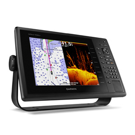
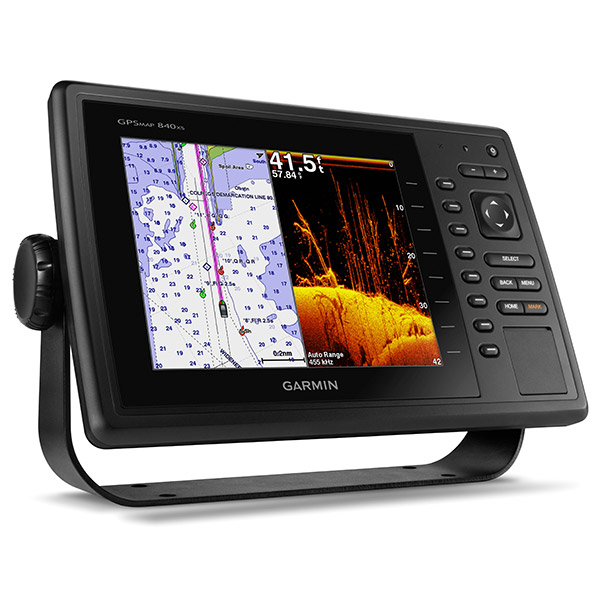
10" Keyed Chartplotter/Sonar Combo for Cruising, Sailing or Fishing- Keyed chartplotter/sonar combo with 10 color SVGA display
- Preloaded worldwide basemap
- Built-in Garmin HD-ID 1 kW sonar, CHIRP and DownVü scanning sonar with CHIRP technology
- High-sensitivity internal 10 Hz GPS/GLONASS receiver
- Supports all Garmin marine radar
Extreme Sonar Capabilities
The built-in sonar capabilities of the GPSMAP 1020xs gives you the freedom and flexibility to choose from several optional transducers, including traditional, CHIRP and all-in-one HD-ID/DownVü scanning sonar with CHIRP technology. Add a GCV 10 black box sonar for both DownVü and SideVü scanning sonar with CHIRP technology (sold separately).
When used with a compatible CHIRP transducer (sold separately), GPSMAP 1020xs displays crystal-clear sonar images detailing fishing hot spots, ship wreckage or a diving location. With Garmin CHIRP technology, you get remarkable target separation and resolution at extraordinary depths, and can dial into specific frequencies to target certain species of sport fish. Bottom contours are more visible, even at speed, and signal noise can be suppressed at greater depths to provide a more timely interpretation of whats below for safer navigation and better fishing.
Super-fast 10 Hz GPS/GLONASS
High-sensitivity internal 10 Hz GPS/GLONASS provides position and heading updates 10 times per second. It displays fluid on-screen location and proves to be incredibly accurate when marking 5,000 waypoints and navigating.
NMEA 2000® Support
This combo allows you to add more capabilities to your boat. It provides NMEA 2000 support so you can see valuable information on your screen for Garmin autopilot, engine data, SiriusXM® Weather radar and more.
Specifications
Physical & PerformanceUnit dimensions, WxHxD 14.1" x 9.3" x 2.9 " (35.9 x 23.6 x 7.5 cm)
Display size, WxH 8.3" x 6.2", 10.4" diagonal (21.1 x 15.8 cm, 26.4 cm diagonal)
Display resolution, WxH 800 x 600 pixels
Display type SVGA display
Weight 4.7 lb (2.1 kg)
Waterproof Yes (IPX7)
Maps & Memory
Basemap Yes
Ability to add maps Yes (via SD card)
Accepts data cards Dual SD card slots
Waypoints/favorites/locations 5,000
Routes 100
Features & Benefits
CANet® compatible No
Supports AIS (tracks target ships' position) Yes
Supports DSC (displays position data from DSC capable VHF radio) Yes
Audible alarms Yes
Tide tables Yes
Sun and moon information Yes
3-D map view Yes
Dual-frequency sonar capable Yes
Dual-beam sonar capable Yes
Split-screen zoom Yes
Split-screen sonar/gps Yes
Ultrascroll® (displays fish targets at higher boat speeds) Yes
See-thru® technology (exposes fish hidden in cover) Yes
Fish Symbol ID (helps identify fish targets) Yes
AutoGain Technology (minimizes clutter, maximizes targets) Yes
Whiteline (indicates hard or soft bottom) No
Adjustable depth line (measures depth of underwater objects) Yes
A-scope (real time display of fish passing through transducer beam) Yes
Bottom lock (shows return from the bottom up) Yes
Water temperature log and graph Yes
Water temperature sensor included Yes
Other Specs
Frequency 50/77/200 kHz, DownVü
Transmit power 1 kW (600W CHIRP)
Voltage range 10V-32V input
Maximum depth
1750 ft @ 50kHz, saltwater, Garmin dual freq transducer @ 500W
2700 ft @ 50kHz, saltwater, Airmar B260 transducer @ 1000W
(depth capacity is dependent on water bottom type and other water conditions)
Additional
HD-ID 1kW sonar: yes
Garmin Helm support: yes
Sonar recording with playback in HomePort: yes
Wireless connectivity: yes
Compatible with GCV 10: yes
Item number: 010-01183-01
UPC: 753759111472
Package weight: 6.16 lb
Other Products in the Series: