GARMIN Gpsmap 820


This item is brand new
$756.95
Backorder, ships in 3 - 4 weeks
|cw|sw


GA 30 GPS antenna (GA 29 replacement)
GPS 17x NMEA 2000 GPS Receiver

GXM 52 - SiriusXM Marine Receiver
GDL 40 Weather Receiver
GXM 51 - Weather and Audio XM Receiver
GHP 10 Marine Autopilot System with GHC 20
GHP 10 Marine Autopilot System with GHC 10

GHP 10V Marine Autopilot System with GHC 10
GHP 10V Marine Autopilot System with GHC 20

GHP 12 Sailboat Autopilot System with GHC 10

GHP 20 Marine Autopilot System for Steer-by-Wire with GHC 10

GHP 20 Marine Autopilot System for Viking with GHC 10
GHP 20 Marine Autopilot System for Yamaha Helm Master with GHC 10
GHP 20 Marine Autopilot System with SmartPump and GHC 10

GHP Reactor Hydraulic Autopilot Corepack

GHP Reactor Mechanical Retrofit Solenoid Corepack

GHP Reactor Hydraulic Corepack with SmartPump

GHP Reactor Steer-by-wire Standard Corepack

GHP Reactor Steer-by-wire Corepack for Yamaha Helm Master

GHP Reactor Steer-by-wire Corepack for Viking VIPER

GHP Reactor Steer-by-wire Corepack for Volvo-Penta

GHP Compact Reactor Hydraulic Autopilot Starter Pack


GCV 10 SideVu DownVu CHIRP Scanning Sonar


Ais 300
Ais 600
VHF 300 Black
VHF 300 AIS Black
VHF 100 Black
VHF 100i Black
VHF 100 Silver Grey
VHF 100i International
Vhf 110
VHF 200 Black
VHF 200i Black
VHF 200 Silver Gray
VHF 200i International
VHF 210 AIS Marine Radio
VHF 300 Silver Gray
VHF 300i International
VHF 300i Black
VHF 300i AIS Black
VHF 300 AIS Silver Gray
VHF 300i AIS International

BCN weather cap


Panoptix PS31 Forward Transducer
Panoptix PS60 Thru-hull Down Transducer
Panoptix PS21 LiveVu Forward Transducer
Panoptix PS21-TM Forward Transom Mount Transducer


NMEA 2000 Transducer Adapter Kit
GMR 18 HD Radar
GMR 18 xHD Radar
GMR 24 xHD Radar

GMR 604 xHD Open Array and Pedestal

GMR 606 xHD Open Array and Pedestal

GMR 1204 xHD Open Array and Pedestal

GMR 1206 xHD Open Array and Pedestal

GMR 404/406 Radar Pedestal
GMR 404 Open Array Radar
GMR 406 Open Array Radar
GMR 18 Radar

GMR 24 Radar

GMR 18 HD Plus Radar
GMR 24 HD Radar
GMR 404 xHD Open Array Radar and Pedestal
GMR 406 xHD Open Array Radar and Pedestal

GMR 424 xHD2 Open Array Radar and Pedestal

GMR 624 xHD2 Open Array Radar and Pedestal

GMR 626 xHD2 Open Array Radar and Pedestal

GMR 1224 xHD2 Open Array Radar and Pedestal

GMR 1226 xHD2 Open Array Radar and Pedestal


GBT 10 Bennett Trim Tab Adapter


GWind, GMI 20, DST800 Bundle


GWind, GMI 20, GNX 20, DST800 Bundle

GWind, GMI 20, DST800, GNX 20 Wireless Bundle

9-axis Heading Sensor
Gmi 10


GNX Wind Wired Sail Pack

GWS 10 Wind Sensor with GMI 10 and Smart Triducer Bundle
GWS 10 Wind Sensor
GWS 10 Wind Sensor with GMI 10 Bundle

GWS 10 Wind Sensor with GMI 20 Bundle

GWS 10 Wind Sensor with GMI 20 and DST800 Bundle

GWind, GMI 20, DST800 Wireless Bundle


Airmar Smart Triducer, Plastic Thru, NMEA 2000

Access, Smart Transducer, P39 Transom, Temp, NMEA 2000


DT800 12 tilt NMEA2000 Smart Transducer Plastic


Suggested Maps and Software:
 | Inland Lakes |
 | BlueChart g2, g3 Vision |
 | BlueChart g2, g3 on micro SD card with adapter |
 | Garmin Extras |
 | LakeVu HD Ultra |
 | LakeVu HD |
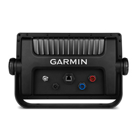
Contents of the package
- GPSMAP 820 with worldwide basemap
- Power/data cable
- Bail mount
- Flush mount
- Protective cover
- Documentation
Features
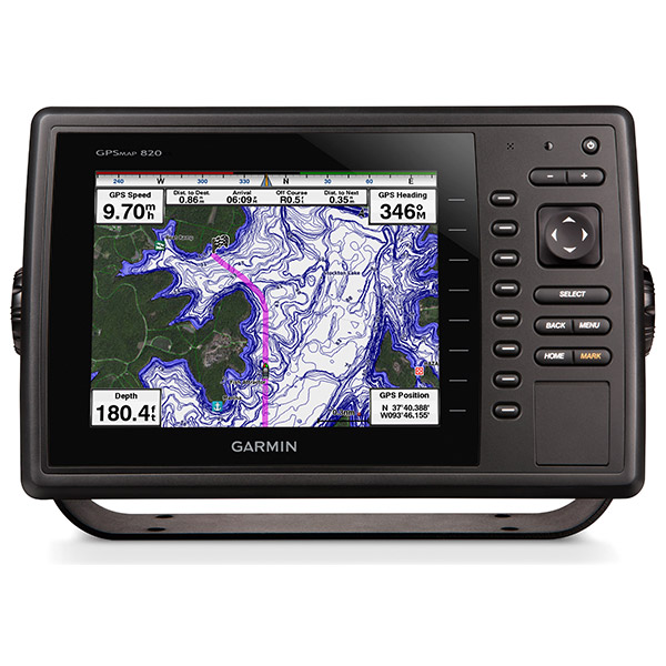
8" Keyed Chartplotter for Cruising, Sailing or Fishing- 8 color SVGA display with keyed control
- Preloaded with worldwide basemap
- High-sensitivity internal 10 Hz GPS/GLONASS receiver
- Compatible with LakeVü HD Ultra, BlueChart® g2 and BlueChart g2 Vision®
- Supports all Garmin marine radar
With NMEA 2000® support for autopilot capability, engine data, SiriusXM® Weather and more, the GPSMAP 820 is compatible with LakeVü HD Ultra, BlueChart g2 and BlueChart g2 Vision. It also supports all Garmin marine radar.
For even more functionality, wirelessly connect to Apple® (mobile digital device) for BlueChart® Mobile. The chartplotter includes 2 SD data card slots, allowing for gigabytes of storage. It can be flat, flush or bail mounted.
Networking
The GPSMAP 820xs offers select networking capabilities that allow you to share features with other compatible GPSMAP units, such as radar, GCV 10 DownVü and SideVü scanning sonar, supplemental maps, and user data, such as
waypoints, routes and tracks.
Special Sailing Features
Supported sailing features include laylines, enhanced wind rose, heading and course-over-ground lines,and true wind data fields.
Specifications
Physical & PerformanceUnit dimensions, WxHxD 11.5" x 7.4" x 2.9" (29.3 x 18.8 x 7.4 cm)
Display size, WxH 6.4" x 4.8", 8.0" diagonal (16.2 x 12.1 cm, 20.3 cm diagonal)
Display resolution, WxH 800 x 600 pixels
Display type SVGA display
Weight 3.5 lb (1.6 kg)
Battery none
Battery life none
Waterproof Yes (IPX7)
High-sensitivity receiver Yes
Antenna internal
NMEA input/output NMEA 0183 compatible and NMEA 2000® certified
Maps & Memory
Basemap Yes
Preloaded maps No
Ability to add maps Yes (via SD card)
Built-in memory none (cannot load maps to internal memory)
Waypoints/favorites/locations 5,000
Routes 100
Track log 50,000 points; 50 saved tracks
Features & Benefits
Radar compatible Yes
Sonar Compatible Yes (with optional GCV 10)
Garmin Marine Network compatible Yes (select features)
Touchscreen No
Supports AIS (tracks target ships' position) Yes
Supports DSC (displays position data from DSC capable VHF radio) Yes
Audible alarms Yes
Tide tables Yes
Hunt/fish calendar No
Sun and moon information Yes
3-D map view Yes (with optional BlueChart g2 Vision card)
Auto Guidance Yes (with optional BlueChart g2 Vision card)
SiriusXM® Weather and Radio compatible Yes
Automatic routing (turn by turn routing on roads) No
Voice prompts (e.g. "Turn right in 500 ft.") No
Speaks street names (e.g. "Turn right ON ELM STREET in 500 ft.") No
Headphone jack/audio line-out No
Audio/video input/output No
Portable No
Automotive/motorcycle-friendly No
Additional
Garmin Helm support: yes
Wireless connectivity: yes
GCV 10 compatible: yes
Item number: 010-01182-00
UPC: 753759111441
Package weight: 11 lb
Other Products in the Series: