GARMIN GPSMAP 1042xsv with Transducer


This item is brand new
$1,799.99
Backorder, ships in 3 - 4 weeks
|cw|sw|wi


GPS 19x NMEA 2000 GPS Receiver


GXM 52 - SiriusXM Marine Receiver
GHP 10 Marine Autopilot System with GHC 20
GHP 10 Marine Autopilot System with GHC 10

GHP 10V Marine Autopilot System with GHC 10
GHP 10V Marine Autopilot System with GHC 20

GHP 12 Sailboat Autopilot System with GHC 10

GHP 20 Marine Autopilot System for Steer-by-Wire with GHC 10

GHP 20 Marine Autopilot System for Viking with GHC 10
GHP 20 Marine Autopilot System for Yamaha Helm Master with GHC 10
GHP 20 Marine Autopilot System with SmartPump and GHC 10

GHP Reactor Hydraulic Autopilot Corepack

GHP Reactor Mechanical Retrofit Solenoid Corepack

GHP Reactor Hydraulic Corepack with SmartPump

GHP Reactor Steer-by-wire Standard Corepack

GHP Reactor Steer-by-wire Corepack for Yamaha Helm Master

GHP Reactor Steer-by-wire Corepack for Viking VIPER

GHP Reactor Steer-by-wire Corepack for Volvo-Penta

GHP Compact Reactor Hydraulic Autopilot Starter Pack


GSD 26 Digital Sonar
GCV 10 SideVu DownVu CHIRP Scanning Sonar

GSD 21 Analog Sonar
GSD 22 Digital Sonar


Ais 300
Ais 600
VHF 300 Black
VHF 300 AIS Black
VHF 100 Black
VHF 100i Black
VHF 100 Silver Grey
VHF 100i International
Vhf 110
VHF 200 Black
VHF 200i Black
VHF 200 Silver Gray
VHF 200i International
VHF 210 AIS Marine Radio
VHF 300 Silver Gray
VHF 300i International
VHF 300i Black
VHF 300i AIS Black
VHF 300 AIS Silver Gray
VHF 300i AIS International


Nautix In-view Display


Split Connector 50 ft Right Angle RJ45 Plug


Panoptix PS31 Forward Transducer
Panoptix PS60 Thru-hull Down Transducer
Panoptix PS21 LiveVu Forward Transducer
Panoptix PS21-TM Forward Transom Mount Transducer


NMEA 2000 Transducer Adapter Kit

GNT 10 NMEA 2000 - ANT Transceiver
GMR 18 HD Radar
GMR 18 xHD Radar
GMR 24 xHD Radar

GMR 604 xHD Open Array and Pedestal

GMR 606 xHD Open Array and Pedestal

GMR 1204 xHD Open Array and Pedestal

GMR 1206 xHD Open Array and Pedestal

GMR 404/406 Radar Pedestal
GMR 404 Open Array Radar
GMR 406 Open Array Radar
GMR 18 Radar

GMR 24 Radar
GMR Fantom 18 Solid-state Radar
GMR Fantom 24 Solid-state Radar
GMR Fantom 4
GMR Fantom 6

GMR 18 HD Plus Radar
GMR 24 HD Radar
GMR 404 xHD Open Array Radar and Pedestal
GMR 406 xHD Open Array Radar and Pedestal

GMR 424 xHD2 Open Array Radar and Pedestal

GMR 624 xHD2 Open Array Radar and Pedestal

GMR 626 xHD2 Open Array Radar and Pedestal

GMR 1224 xHD2 Open Array Radar and Pedestal

GMR 1226 xHD2 Open Array Radar and Pedestal

GBT 10 Bennett Trim Tab Adapter


GC 10 NTSC Marine Camera
GC 10 NTSC Reverse Marine Camera

GWind, GMI 20, DST800 Bundle


GWind, GMI 20, GNX 20, DST800 Bundle

GWind, GMI 20, DST800, GNX 20 Wireless Bundle

9-axis Heading Sensor


GC 12 Marine Camera

GC 10 PAL Marine Camera
GC 10 PAL Reverse Marine Camera
GCL 20 NTSC Low-light Imaging Camera
GCT 20 QVGA 30Hz Thermal Imaging Camera
GCT 30 VGA 9Hz Thermal Imaging Camera
GCL 20 PAL Low-light Imaging Camera
GCT 20 QVGA 9Hz Thermal Imaging Camera
GCT 30 VGA 30Hz Thermal Imaging Camera

Gmi 10


GNX Wind Wired Sail Pack

GNX Wind Wireless Sail Pack

GWS 10 Wind Sensor with GMI 20 Bundle

GWS 10 Wind Sensor with GMI 20 and DST800 Bundle

GWS 10 Wind Sensor with GMI 10 and Smart Triducer Bundle
GWS 10 Wind Sensor
GWS 10 Wind Sensor with GMI 10 Bundle


GWind Wireless Transducer


GWind, GMI 20, DST800 Wireless Bundle


GNX gWind Wireless Pack


GT41-TH Thru-Hull CHIRP DownVu, SideVu, Traditional Transducer with Temp 12-pin
GT41-THP Traditional 600W, 50/200kHz, ClearVu/SideVu CHIRP 260kHz, 455kHz Pair w/Fairing Block
GT50M-TH Thru-Hull CHIRP DownVu, SideVu, CHIRP Traditional Transducer with Temp 12-pin
GT50M-THP Pair Thru-Hull CHIRP DownVu, SideVu, CHIRP Traditional Transducer with Temp 12-pin


GT40-TM Transom CHIRP DownVu, SideVu, Traditional Transducer with Temp 12-pin


M260-8G 1kW 200/50kHz In-Hull Plastic Transducer


M265LH DO 42 210 kHz 1kW CHIRP In-hull/Pocket Plastic Transducer


R599LH 2-3kW CHIRP Transducer


B175L no connector 1kW 12 tilt CHIRP Bronze Transducer
B175H no connector 1kW 20 tilt CHIRP Bronze Transducer

P72-8G 500W 77/200 kHz Transducer


B75H 0 deg tilt CHIRP Transducer


B75L 12 deg tilt CHIRP Transducer


B164 1kW 0 tilt 200/50kHz Bronze Transducer 8-pin


Wide beam bare wires 0 Tilt 150-250 kHz 1kW CHIRP Bronze Transducer
Wide beam bare wires 12 Tilt 150-250 kHz 1kW CHIRP Bronze Transducer
Wide beam bare wires 20 Tilt 150-250 kHz 1kW CHIRP Bronze Transducer
B175H no connector 1kW 0 tilt CHIRP Bronze Transducer
B175H no connector 1kW 12 tilt CHIRP Bronze Transducer
B175L 8pin 1kW 0 tilt CHIRP Bronze Transducer
B175L no connector 1kW 20 tilt CHIRP Bronze Transducer
B175M no connector 1kW 0 tilt CHIRP Bronze Transducer
B175M no connector 1kW 12 tilt CHIRP Bronze Transducer
B175M no connector 1kW 20 tilt CHIRP Bronze Transducer

B265LH CHIRP Transducer
B45-DT-8G Thru-Hull 50/200 kHz Bronz Narrow Stem 8pin Transducer

CM599 LH 2-3kW CHIRP Transducer

CM599 LM 2-3kW CHIRP Pocket Mount Transducer

PM265LM DT 42-135 kHz 1kW CHIRP Poket Bronze Transducer

R109LH 38-210 kHz 2kW CHIRP Urethane Thru-Hull Transducer

R509LH DT 28-210 kHz 2-3kW CHIRP Epoxy Thru-Hull Transducer

R509LM DT 28-130 kHz 2-3kW CHIRP Epoxy Thru-Hull Transducer

SS164 0 deg tilt 1kW Transducer 8pin

SS164 12 deg tilt 1kW Transducer 8 pin

SS164 20 deg tilt 1kW Transducer 8 pin


P32-8G DST 77/200 Khz 45/15 beam Transom Mount 8pin Triducer

TM150M 95-155 kHz Trunsom mount Plastic CHIRP 8pinTransducer
GT21-TM - Transom Mount DownVu 500W CHIRP 260/455 kHz Traditional 600W 50/200 kHz Transducer w/Temp


TM265LH DT 42-210 Khz 1kW CHIRP Urth Transom Transducer

For Garmin TM258-8G DT Cone 3-21 1kW 200/50kHz Transom 8pin Transducer


Airmar Smart Triducer, Plastic Thru, NMEA 2000

Access, Smart Transducer, P39 Transom, Temp, NMEA 2000


DT800 12 tilt NMEA2000 Smart Transducer Plastic


CV51M-THP ClearVu CHIRP SideVu Thru Hull Pair


Wireless Remote Control
Virb X
Virb Xe

GRID (Remote Input Device)
NOH Virb XE

Meteor 300 Marine Audio System

Meteor 300 Marine Audio System with Speakers
VIRB XE Cycling Bundle
VIRB XE Auto Racing Bundle
VIRB XE Aviation Bundle
VIRB Ultra 30


Suggested Maps and Software:
 | Inland Lakes |
 | BlueChart g2, g3 Vision |
 | BlueChart g2, g3 on micro SD card with adapter |
 | Garmin Extras |
 | LakeVu HD |
Contents of the package
- GPSMAP 1042xsv chartplotter
- Power/data cable
- NMEA 2000 T-connector
- NMEA 2000 drop cable (2 m)
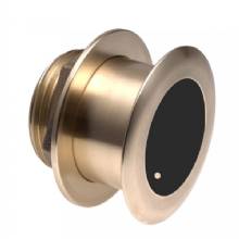
- Transducer (GT52HW-TM)
- Bail mount kit with knobs
- Flush mount kit with gasket
- Protective cover
- Trim piece snap covers
- Documentation
Features
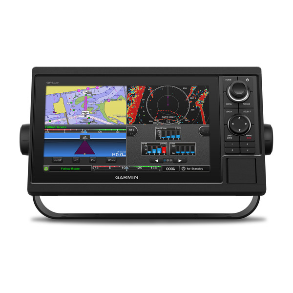
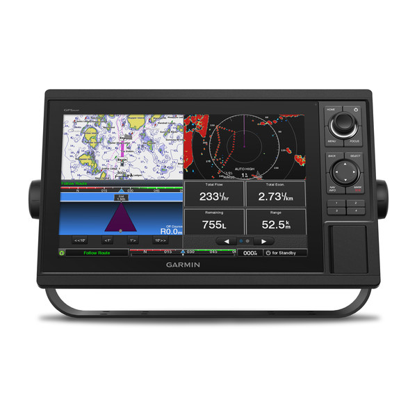
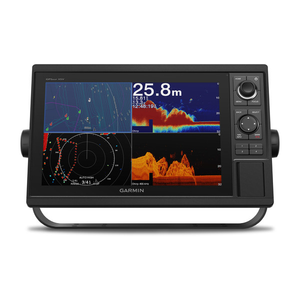
10-inch Chartplotter/Sonar Combo Is All-in-1 Solution10-inch color display with keypad interface and multifunction control knob
Includes transducer with high wide CHIRP, 250 W and CHIRP ClearVü/SideVü, 455/800, 500 W (also available without transducer)
Preloaded U.S. LakeVü HD maps and BlueChart® g2 HD charts
High-sensitivity internal 10 Hz GPS and GLONASS receiver
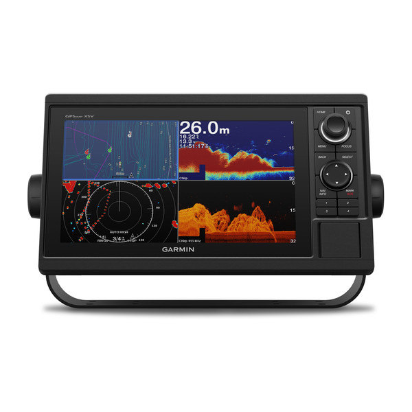
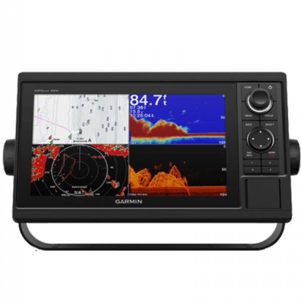
Built-in Garmin CHIRP sonar, CHIRP ClearVü and CHIRP SideVü scanning sonar and Panoptix support (transducers sold separately)
Experience an advanced all-in-1 solution with our 10-inch GPSMAP 1042xsv keyed combo. Includes transducer for Garmin CHIRP sonar, CHIRP ClearVü and CHIRP SideVü (also available without transducer). It also has built-in support for Panoptix all-seeing sonar and premium Garmin sonar modules (transducers sold separately). Features a large, bright screen coupled with a quick and easy-to-use keypad interface with user-programmable keys and a multifunction control knob.
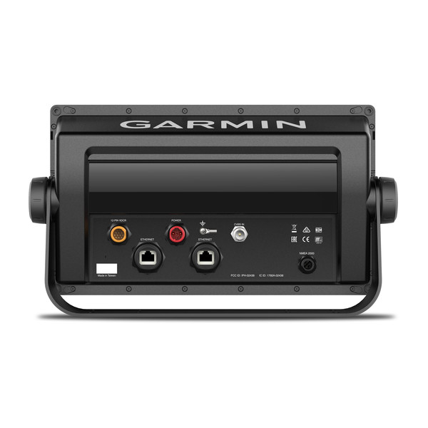
Complete Network Sharing
Garmin Marine Network support allows sharing of sonar, maps, user data, dome or open-array radar, IP cameras and Panoptix sonar among multiple units. Includes NMEA 2000® network connectivity and NMEA 0183 support for autopilots, digital switching, weather, media, VHF, AIS and other sensors.
Built-in Wi-Fi® Connectivity
Enjoy built-in Wi-Fi connectivity for BlueChart Mobile 2.0 and Garmin Helm apps. Garmin Helm allows you to view and control your compatible chartplotter from a compatible smartphone or tablet while providing enhanced situational awareness for the mariner. With BlueChart Mobile, a free app downloaded from the App Store, you can get reliable weather information while you plan marine routes on your iPad® or iPhone® then wirelessly transfer them to your boats compatible networked Garmin chartplotter. You can even stream and control a VIRB action camera from the chartplotter.
Built-in ANT® Connectivity
Enjoy built-in ANT wireless connectivity directly to quatix® marine watches, Garmin Nautix in-view display, gWind Wireless 2 transducer, GNX Wind marine instrument and wireless remote controls. You can even stream and control a VIRB action camera from the chartplotter.
Built-in Sonar Capabilities
Right out of the box, you have access to some amazing sonar capabilities; all you have to add are transducers. Comes with built-in Garmin 1 kW CHIRP sonar, CHIRP ClearVü and CHIRP SideVü scanning sonar. It even supports Panoptix all-seeing sonar, premium Garmin sonar modules and a wide range of transducers (sold separately).
Networked combos can share their internal sonar with any other device on the network. You can also choose what information is overlaid on the sonar screen; for example, radar, time of day or GPS speed.
Heading, Position Refreshed 10 Times per Second
Fast, responsive built-in 10 Hz GPS and GLONASS refreshes your position and heading 10 times each second to make your movement on the screen more fluid. It makes dropping up to 5,000 accurate waypoints and finding your way back to them quick and easy.
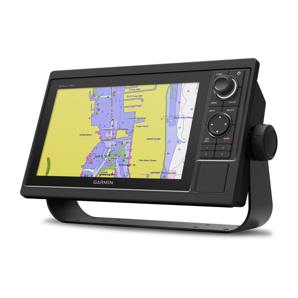
Preloaded with Exceptional Garmin Cartography
You get both LakeVü HD inland waters mapping and BlueChart g2 HD coastal charts.
LakeVü HD provides highly detailed freshwater maps that include 17,000+ U.S. lakes, rivers and reservoirs. Included in those are more than 13,000 HD lakes with 1-foot contours shoreline to shoreline. Upgrade to LakeVü HD Ultra with Max Def Lakes.
BlueChart g2 HD provides basic coastal charts, tidal stations, currents, depth contours, IALA symbols and fishing charts. It also transitions smoothly between zoom levels and delivers seamless continuity across chart boundaries.
Upgrade to Our Best Maps on the Water
Two SD card slots provide expandable memory for accessory map purchases, such as LakeVü HD Ultra or BlueChart g2 HD or BlueChart® g2 Vision® HD, which adds Garmin patented Auto Guidance¹and other great features.
Quickdraw Contours to Create Your Own HD Maps
Instantly create personalized HD fishing maps on screen with 1-foot contours. Tailor them to fit your needs. These are your maps you own them. Keep the data to yourself, or share it with the Quickdraw Community on Garmin Connect.
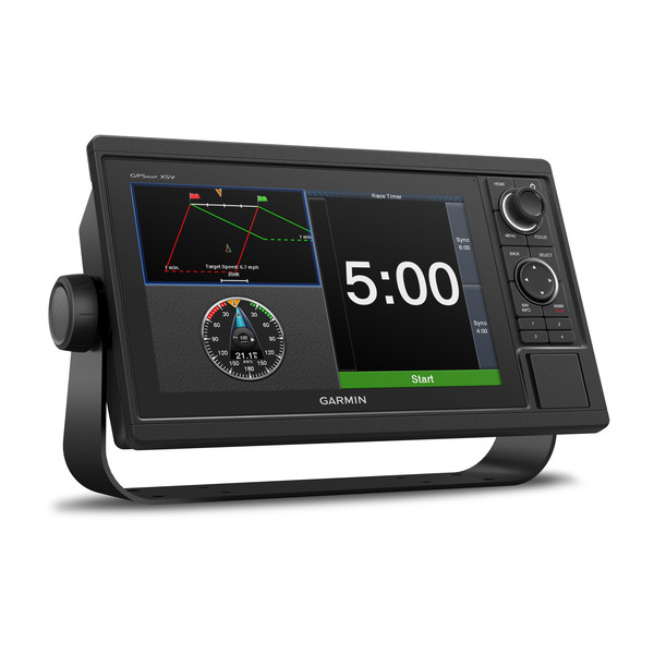
Built-in SailAssist Features
To help you gain a wind-maximizing competitive edge, your chartplotter features a pre-race guidance page that shows your virtual starting line along with data fields showing laylines, time to burn before the start and a race timer that can be synchronized across all your networked Garmin GPS products. In addition, other supported sailing features include an enhanced wind rose, heading and course-over-ground lines, set and drift, true and apparent wind data and more.
GPX Waypoints Transfer
If you have waypoints, tracks or frequently used routes stored on another manufacturers GPS product or on a Garmin handheld device its easy to transfer those items to your new Garmin chartplotter via industry-standard GPX software formatting.
¹Auto Guidance is for planning purposes only and does not replace safe navigation operations.
Specifications
Physical & Performance
| Physical dimensions | 12.5" x 7.3" x 2.7" (318 x 185 x 69 cm) |
|---|---|
| Display size | 8.8" x 4.9" (224 x 125 cm) |
| Display resolution | 1024 x 600 pixels |
| Display type | WSVGA display |
| Weight | 4.1 lbs (1.85 kg) |
| Antenna | Internal_or_external_over_NMEA_2000 |
| NMEA 2000® compatible | |
| NMEA 0183 compatible | |
| SiriusXM Weather & Radio compatible | |
| Power consumption | Max power usage at 10 Vdc: 32.4 W Typical current draw at 12 Vdc: 1.9 A Max current draw at 12 Vdc: 2.7 A |
| Mounting options | Bail or flush |
| Garmin Marine Network ports | 2 |
Maps & Memory |
|
| Preloaded maps | BlueChart® g2 (coastal maps) and LakeVü HD (inland maps) |
|---|---|
| Accepts data cards | 2 SD cards |
| Waypoints | 5,000 |
| Routes | 100 |
| Track log | 50,000 points; 50 saved tracks |
Chartplotter Features |
|
| Garmin Radar compatible | |
|---|---|
| Garmin Sonar compatible | Yes (built-in) |
| Garmin SmartMode compatible (customizable monitor presets) | |
| Supports AIS (tracks target ships position) | |
| Supports DSC (displays position data from DSC-capable VHF radio) | |
| Tide tables | |
| Garmin Meteor Audio System compatible | |
| Supports FUSION-Link compatible radios | |
| GSD Black Box sonar support | |
| GCV Black Box sonar support | |
| BlueChart® Mobile (planning) compatible | |
| Garmin Helm compatible | |
| GRID (Garmin Remote Input Device) compatible | |
| Wireless remote compatible | |
Sonar Features & Specifications |
|
| Dual-frequency (50/200 kHz) sonar capable | |
|---|---|
| Dual-beam (77/200 kHz) sonar capable | |
| Frequencies supported | Traditional: 50/77/83/200 kHz CHIRP (low, medium, high) ClearVü/SideVü (260/455/800 kHz) (dependent on transducer) |
| Transmit power | 1 kW traditional; 1 kW single channel CHIRP |
| CHIRP sonar technology | Yes (Built-in) |
| ClearVü | Yes with CHIRP (built-in) |
| SideVü | Yes with CHIRP (built-in) |
| Maximum depth | 5,000 ft at 1kW (depth capacity is dependent on water bottom type and other water conditions) |
| Bottom lock (shows return from the bottom up) | |
| Water temperature log and graph | |
| Sonar recording | |
| Sonar history rewind | |
Connections |
|
| Transducer pin numbers | 12 |
|---|---|
| NMEA 0183 input ports | 1 |
| NMEA 0183 output ports | 1 |
| Video input ports | 1 BNC |
| Video output ports | None |
| Wireless connectivity | |
Item number: 010-01740-11
UPC: 753759168353
Package weight: 10.9 lb
Other Products in the Series: