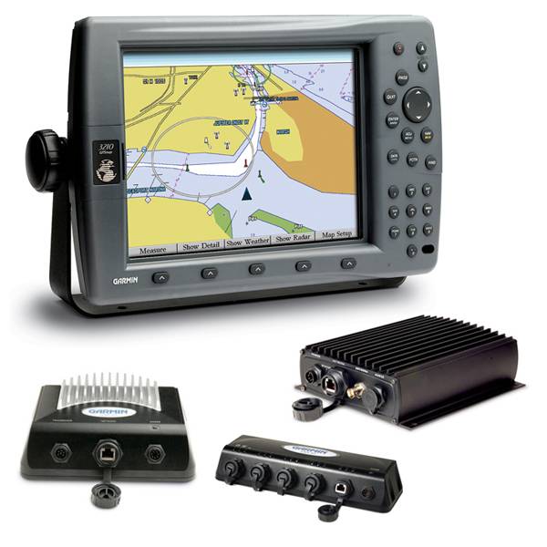
GARMIN GPSMAP 3210, GDL 30A, GSD22, GMS10 Bundle
This item is brand new
$1,579.95
This item ships within 9 days


Gdl 30A

GSD 26 Digital Sonar
GSD 22 Digital Sonar

Vehicle power cable

16 MB data card, RoHS

32 MB data card, RoHS

64 MB data card, RoHS

128 MB data card, RoHS

256 MB data card, RoHS
512 MB data card, RoHS


Split Connector 50 ft Right Angle RJ45 Plug
GMR 18 HD Radar

GMR 604 xHD Open Array and Pedestal

GMR 606 xHD Open Array and Pedestal

GMR 1204 xHD Open Array and Pedestal

GMR 1206 xHD Open Array and Pedestal

GMR 404/406 Radar Pedestal
GMR 404 Open Array Radar
GMR 406 Open Array Radar
GMR 18 Radar

GMR 24 Radar
GMR 24 HD Radar
GMR 404 xHD Open Array Radar and Pedestal
GMR 406 xHD Open Array Radar and Pedestal

M260-6G 1kW 200/50KHz Transducer In hull 6 pin f GSD22

B260-6BR DT Cone 19/6 1kW 200/50KHz Bronze 6pin Transducer
USB 2.0 data card programmer, RoHS
Suggested Maps and Software:
 | BlueChart g2 on Datacard |
 | BlueChart on Garmin Datacard |
 | Garmin Extras |
Contents of the package
Features
GPSMAP 3210, a 10.4-inch color screen chartplotter with preloaded marine maps, features high-speed processing and the versatility of a multifunction display.
The GPSMAP 3210 comes preloaded with U.S. marine detailed maps for the entire coast of the United States, including Alaska and Hawaii. These maps are based on BlueChart g2 technology, so they layer smoothly and are integrated for easy panning, scrolling and zooming. The maps also provide a choice between 3D "mariner's-eye-view", or the familiar 2D direct-overhead view to make chart reading and orientation easier.
The 3210 connects easily to the Garmin Marine Network, so you can interface with additional MFDs and add remote sensors and sonar. Its design makes it easy to install in cabin bulkheads or open cockpits. The 3210 also provides a remote control, VGA output and video input options, so you can connect a live video feed from your engine room or other area of the boat.
With an optional subscription to XM WX Satellite Weather and the addition of a GDL 30 or 30A weather receiver, you can receive up-to-the-minute weather information for the U.S. You can see detailed real-time weather patterns, including NEXRAD radar, right on the 3210's screen by connecting through the Garmin Marine Network. The GDL 30A also provides XM Satellite Radio service.
The 3210 accepts optional BlueChart g2 marine cartography, which brings you 3D maps, tides and currents, depth contours, navaids, port plans, marine services and points of interest (POIs). Best of all, with these optional maps, you can view real, detailed aerial photos of harbors, marinas and other important marine landmarks and places, right on your chartplotter.
GDL 30A
Mariners using the GDL 30 receiver can view the same leading-edge satellite weather data provided to television meterologists across the United States. The GDL 30 receives XM WX Satellite Weather data, including animated NEXRAD weather radar and forecasts, current conditions, surface air pressure, visibility, precipitation, wind data, wave data, storm cell size, speed and direction and surface temperatures, for your boats current location or along a projected path. This information appears right on the Map page of your chartplotter, so you can see how the weather will affect your current position.
To take advantage of this detailed information, just connect your GDL 30 to the Garmin Marine Network, so any chartplotter can access and control it. You can choose one of several subscription packages that offer different types of services.
The GDL 30 provides weather data and audio entertainment for the United States (except Alaska and Hawaii) only.
GSD 22
This black-box sounder connects to your chartplotter over the Garmin Marine network to provide high-speed data returns and super-crisp detail. Once connected, any plotter on the network can view the 22's detailed sonar data and overlay it on the map page. You can also use the GSD 22 with Garmin's CANet® to connect to non-network chartplotters.
The GSD 22's digital design provides extraordinary target definition and deep water performance and allows it to transmit at up to 2 kW, depending on your transducer. The 22 also adjust gain and transmit power automatically to optimize the returns for shallow water as well. It can connect to a dual-frequency transducer and works with everything from a standard 500 watt transom-mount transducer to a heavy-duty 2 kW thru-hull or in-hull transducer and can reach a depth of up to 5,000 feet.
GMS 10
The GMS 10 Network Port Expander allows you to connect multiple chartplotters and sensors over the Garmin Marine Network. With this robust 100-megabit switch, you can connect multiple MFDs and sensors to the Garmin Marine Network and gain the benefit of Ethernet-like data transfer speeds up to 10 times faster than some competitive systems.
The GMS 10 and the Garmin Marine Network are completely plug-and-play, which means that all peripherals are automatically detected and readily accessible once theyre connected to the network. Likewise, you can easily expand your system using the same standard data cable to plug additional units and displays into the GMS 10 network ports.
All connections are totally waterproof, and sealed covers keep harmful moisture away from unused data ports.


Specifications
Physical & Performance:
Unit dimensions, WxHxD: 13.1" x 8.8" x 3.25" (33.3 x 22.4 x 8.3 cm)
Display size, WxH: 8.3" x 6.2", 10.4" diagonal (21.1 x 15.7 cm, 26.4 cm diagonal)
Display resolution, WxH: 640 x 480 pixels
Display type: 256-color TFT
Weight: 5 lb (2.27 kg)
Battery: none
Battery life: none
Waterproof: yes (IPX7)
Antenna: remote
NMEA input/output: NMEA 0183
Maps & Memory:
Basemap: yes
Preloaded maps: yes (coastal maps)
Ability to add maps: yes
Built-in memory: none (cannot load maps to internal memory)
Accepts data cards: Garmin data cards
Waypoints/favorites/locations: 4,000
Routes: 50
Track log: 10,000 points
Features:
Garmin radar compatible: yes
Garmin sonar compatible: yes
CANet® compatible: no
Garmin Marine Network compatible: yes
Touchscreen: no
Supports AIS (tracks target ships' position): yes
Supports DSC (displays position data from DSC capable VHF radio): yes
Audible alarms: yes
Tide tables: yes
Hunt/fish calendar: no
Sun and moon information: yes
3-D map view: yes (with optional BlueChart g2 maps)
Auto Guidance: no
Automatic routing (turn by turn routing on roads): no
XM WX Weather & Radio for U.S. compatible: yes
Voice prompts (e.g. "Turn right in 500 ft."): no
Speaks street names (e.g. "Turn right ON ELM STREET in 500 ft."): no
Remote control: yes
Headphone jack/audio line-out: no
Audio/video input/output: yes
Portable: no
Automotive/motorcycle-friendly: no
Item number: 010-00528-01
UPC: 753759053505
Package weight: 24 lb
Other Products in the Series:
 | GARMIN Gpsmap 3005C | |
| GARMIN Gpsmap 3005C NOH | |
| GARMIN Gpsmap 3006C NOH | |
 | GARMIN Gpsmap 3006C | Add to comparison |
| GARMIN Gpsmap 3010C | Add to comparison |
| GARMIN Gpsmap 3205 | Add to comparison |
| GARMIN Gpsmap 3205 NOH | |
| GARMIN Gpsmap 3206 NOH | |
| GARMIN Gpsmap 3206 | Add to comparison |
| GARMIN Gpsmap 3210 | Add to comparison |
| GARMIN Gpsmap 3210 NOH |