GARMIN GPSMAP 4212, GSD 22 Sonar and GXM 51 Network Bundle


This item is brand new
$2,899.95
This item ships within 9 days


GPS 17x NMEA 2000 GPS Receiver
GPS 17x GPS Receiver
GXM 52 - SiriusXM Marine Receiver
Gdl 30A
GXM 51 - Weather and Audio XM Receiver
GHP 10 Marine Autopilot System with GHC 20
GHP 10 Marine Autopilot System with GHC 10

GHP 10V Marine Autopilot System with GHC 10
GHP 10V Marine Autopilot System with GHC 20

GHP 12 Sailboat Autopilot System with GHC 10

GHP 20 Marine Autopilot System for Steer-by-Wire with GHC 10

GHP 20 Marine Autopilot System for Viking with GHC 10
GHP 20 Marine Autopilot System for Yamaha Helm Master with GHC 10
GHP 20 Marine Autopilot System with SmartPump and GHC 10

GHP Reactor Hydraulic Autopilot Corepack

GHP Reactor Mechanical Retrofit Solenoid Corepack

GHP Reactor Hydraulic Corepack with SmartPump

GHP Reactor Steer-by-wire Standard Corepack

GHP Reactor Steer-by-wire Corepack for Yamaha Helm Master

GHP Reactor Steer-by-wire Corepack for Viking VIPER

GHP Reactor Steer-by-wire Corepack for Volvo-Penta

GHP Compact Reactor Hydraulic Autopilot Starter Pack


GSD 26 Digital Sonar
GSD 22 Digital Sonar


Protective Cover (replacement)
Ais 300
Ais 600
VHF 300 Black
VHF 300 AIS Black
VHF 100 Black
VHF 100 Silver Grey
VHF 100i Black
VHF 100i International
Vhf 110
VHF 200 Black
VHF 200i Black
VHF 210 AIS Marine Radio
VHF 300i Black
VHF 300i AIS Black


Bail mount (replacement)


GMR 18 HD Radar
GMR 18 xHD Radar
GMR 24 xHD Radar

GMR 604 xHD Open Array and Pedestal

GMR 606 xHD Open Array and Pedestal

GMR 1204 xHD Open Array and Pedestal

GMR 1206 xHD Open Array and Pedestal

GMR 404/406 Radar Pedestal
GMR 404 Open Array Radar
GMR 406 Open Array Radar
GMR 18 Radar

GMR 24 Radar

GMR 18 HD Plus Radar
GMR 24 HD Radar

GMR 424 xHD2 Open Array Radar and Pedestal

GMR 624 xHD2 Open Array Radar and Pedestal

GMR 626 xHD2 Open Array Radar and Pedestal

GMR 1224 xHD2 Open Array Radar and Pedestal

GMR 1226 xHD2 Open Array Radar and Pedestal


GC 10 NTSC Marine Camera
GC 10 NTSC Reverse Marine Camera

GWind, GMI 20, DST800 Bundle


GWind, GMI 20, GNX 20, DST800 Bundle

GWind, GMI 20, DST800, GNX 20 Wireless Bundle

GC 12 Marine Camera
GC 10 PAL Marine Camera
GC 10 PAL Reverse Marine Camera
GCL 20 NTSC Low-light Imaging Camera
GCT 20 QVGA 30Hz Thermal Imaging Camera
GCT 30 VGA 9Hz Thermal Imaging Camera
GCL 20 PAL Low-light Imaging Camera
GCT 20 QVGA 9Hz Thermal Imaging Camera
GCT 30 VGA 30Hz Thermal Imaging Camera


GWS 10 Wind Sensor with GMI 20 Bundle

GWS 10 Wind Sensor with GMI 20 and DST800 Bundle

GWS 10 Wind Sensor with GMI 10 and Smart Triducer Bundle
GWS 10 Wind Sensor
GWS 10 Wind Sensor with GMI 10 Bundle

GWind, GMI 20, DST800 Wireless Bundle


P79-6G 200/50KHz 12/45deg plastic adjustable Transducer

M260-6G 1kW 200/50KHz Transducer In hull 6 pin f GSD22

M260-6BR 1kW 200/50KHz 6/19deg mounting tank transducer

B164 1kW 20 tilt 50/200 kHz bronze Transducer 6 pin

P319-6G Nylon 0-8 tilt 50/200 kHz Plastic Transducer

B117 0-8 tilt 50/200 kHz Bronze Transducer 6 pin

B60-12-6g 12 Tilt 50/200 kHz Transducer

B60-20-6g 20 Tilt 50/200 kHz Transducer

B744VL-6G Long STEM DTS 50 200 khz 600 w Bronze Thru Hull Transducer

B744V-6G DTS 50 200 khz 600 w Bronze Thru Hull Transducer

B164 1kW 12 tilt 200/50kHz Bronze Transducer 6pin
B164 1kW 0 tilt 200/50kHz bronze, Transducer 6 pin

B22 12 tilt 200KHZ Bronze Transducer

B258-6g 1kW 50/200 kHz thru-hull 6 pin transducer

B260-6BR 1KW 200/50KHz 6/19deg bronze Transducer

B260-6BR DT Cone 19/6 1kW 200/50KHz Bronze 6pin Transducer

B45-DT-6G Thru-Hull 50/200 kHz Bronz Narrow Stem 6pin Transducer


P72-8G 500W 77/200 kHz Transducer


B164 1kW 0 tilt 200/50kHz Bronze Transducer 8-pin
B45-DT-8G Thru-Hull 50/200 kHz Bronz Narrow Stem 8pin Transducer

SS164 0 deg tilt 1kW Transducer 8pin

SS164 12 deg tilt 1kW Transducer 8 pin

SS164 20 deg tilt 1kW Transducer 8 pin


P32-8G DST 77/200 Khz 45/15 beam Transom Mount 8pin Triducer


For Garmin TM258-8G DT Cone 3-21 1kW 200/50kHz Transom 8pin Transducer


Airmar Smart Triducer, Plastic Thru, NMEA 2000

Access, Smart Transducer, P39 Transom, Temp, NMEA 2000

DT800 12 tilt NMEA2000 Smart Transducer Plastic


Suggested Maps and Software:
 | Inland Lakes |
 | BlueChart g2, g3 Vision |
 | BlueChart g2, g3 on micro SD card with adapter |
 | Garmin Extras |
 | LakeVu HD |
Contents of the package
Features
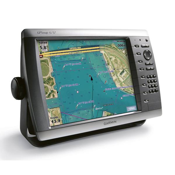
GPSMAP 4212 Chartplotter
The GPSMAP 4212 has preloaded BlueChart® g2 maps of the U.S. coast and displays them on a whopping 12.1 XGA display with crisp, video-quality resolution. The 4212 features highly-detailed BlueChart g2 marine cartography of the coastal United States, including Alaska, Hawaii and the Bahamas. This data provides detailed coastlines, shaded depth contours, navaids, port plans, wrecks, restricted areas and tide and current information. For other areas, the 4212 has a worldwide basemap with high-quality satellite images in place of more traditional maps. With the SD card slot, you can add additional maps without having to connect to a computer.
The 4212s high-speed processor draws maps quickly, and its simple intuitive interface makes navigating easy. To keep tabs on your engine room or other area of your boat, you can also connect a live video feed with the 4212s video input and output options.
With the optional BlueChart g2 Vision SD card, you can add more features such as: 3D mariners eye view or fish eye view above the waterline and below it; High-resolution satellite images and aerial photographs; Auto Guidance technology.
Connect to the Garmin Marine Network
The 4212 connects easily to the high-speed Garmin Marine Network, so you can interface with additional MFDs and add remote sensors. Once connected, you can share information between the 4212 and other chartplotters on your boat. You can also add high-powered radar, sonar and XM satellite weather and radio to your system.
GSD 22 Sonar
This black-box sounder connects to your chartplotter over the Garmin Marine network to provide high-speed data returns and super-crisp detail. Once connected, any plotter on the network can view the 22's detailed sonar data and overlay it on the map page. You can also use the GSD 22 with Garmin's CANet® to connect to non-network chartplotters.
The GSD 22's digital design provides extraordinary target definition and deep water performance and allows it to transmit at up to 2 kW, depending on your transducer. The 22 also adjust gain and transmit power automatically to optimize the returns for shallow water as well. It can connect to a dual-frequency transducer and works with everything from a standard 500 watt transom-mount transducer to a heavy-duty 2 kW thru-hull or in-hull transducer and can reach a depth of up to 5,000 feet.
GXM 51 XM Receiver


Specifications
Physical & Performance:
Unit dimensions, WxHxD: 14.8" x 9.5" x 4.6" (37.6 x 24.1 x 11.7 cm)
Display size, WxH: 9.7" x 7.3", 12.1" diagonal (24.6 x 18.5 cm, 30.7 cm diagonal)
Display resolution, WxH: 1024 x 768 pixels
Display type: XGA display
Weight: 10.0 lb (4.5 kg)
Battery: none
Battery life: none
Waterproof: yes (IPX7)
Antenna: external
NMEA input/output: NMEA 0183, NMEA 2000
Maps & Memory:
Basemap: yes
Preloaded maps: yes (coastal maps)
Ability to add maps: yes
Built-in memory: none (cannot load maps to internal memory)
Accepts data cards: SD card slot (BlueChart g2 Vision cards sold separately)
Waypoints/favorites/locations: 1,500
Routes: 20
Track log: 10,000 points; 20 saved tracks
Features:
Garmin radar compatible: yes
Garmin sonar compatible: yes
CANet® compatible: no
Garmin Marine Network compatible: yes
Touchscreen: no
Supports AIS (tracks target ships' position): yes
Supports DSC (displays position data from DSC capable VHF radio): yes
Audible alarms: yes
Tide tables: yes
Hunt/fish calendar: no
Sun and moon information: yes
3-D map view: yes (with optional BlueChart g2 Vision card)
Auto Guidance: yes (with optional BlueChart g2 Vision card)
Automatic routing (turn by turn routing on roads): no
XM WX Weather & Radio for U.S. compatible: yes
Voice prompts (e.g. "Turn right in 500 ft."): no
Speaks street names (e.g. "Turn right ON ELM STREET in 500 ft."): no
Remote control: yes (optional)
Headphone jack/audio line-out: no
Audio/video input/output: yes
Portable: no
Automotive/motorcycle-friendly: no
Item number: 010-00592-04
UPC: -
Package weight: 27 lb
Other Products in the Series:
| GARMIN Gpsmap 4008 NOH | |
| GARMIN Gpsmap 4008 | Add to comparison |
| GARMIN Gpsmap 4010 | Add to comparison |
| GARMIN Gpsmap 4010 NOH | |
| GARMIN Gpsmap 4012 | Add to comparison |
| GARMIN Gpsmap 4208 NOH | |
| GARMIN Gpsmap 4208 | Add to comparison |
| GARMIN GPSMAP 4208, GSD 22 Sonar and GXM 51 Network Bundle | Add to comparison |
| GARMIN Gpsmap 4210 | Add to comparison |
| GARMIN Gpsmap 4212 | Add to comparison |
| GARMIN Gpsmap 4212 NOH |