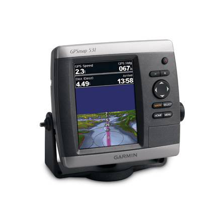
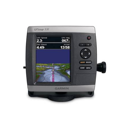
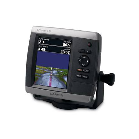
GARMIN GPSMAP 531s without transducer


GHP 10 Marine Autopilot System with GHC 20
GHP 10V Marine Autopilot System with GHC 20

GHP 10V Marine Autopilot System with GHC 10

GHP 12 Sailboat Autopilot System with GHC 10
GHP 20 Marine Autopilot System for Yamaha Helm Master with GHC 10
GHP 20 Marine Autopilot System with SmartPump and GHC 10

GHP 20 Marine Autopilot System for Steer-by-Wire with GHC 10

GHP 20 Marine Autopilot System for Viking with GHC 10

GHP Reactor Hydraulic Autopilot Corepack

GHP Reactor Mechanical Retrofit Solenoid Corepack

GHP Reactor Hydraulic Corepack with SmartPump

GHP Reactor Steer-by-wire Standard Corepack

GHP Reactor Steer-by-wire Corepack for Yamaha Helm Master

GHP Reactor Steer-by-wire Corepack for Viking VIPER

GHP Reactor Steer-by-wire Corepack for Volvo-Penta


20 ft. Extension cable for transducers, with ID 6-pin

10 ft. Extension cable for transducers, ID


Protective cover (replacement)
Ais 300
Ais 600
VHF 100i Black
VHF 100 Silver Grey
VHF 100i International
VHF 200 Silver Gray
VHF 200i Black
VHF 200i International
VHF 300 Silver Gray
VHF 300i International
VHF 300i Black
VHF 300i AIS Black
VHF 300 AIS Silver Gray
VHF 300i AIS International


Flush mounting kit


GBT 10 Bennett Trim Tab Adapter


Speed Sensor


GWind, GMI 20, DST800 Bundle


GWind, GMI 20, GNX 20, DST800 Bundle

GWind, GMI 20, DST800, GNX 20 Wireless Bundle

9-axis Heading Sensor
Gmi 10


GWS 10 Wind Sensor with GMI 20 Bundle

GWS 10 Wind Sensor with GMI 20 and DST800 Bundle

GWS 10 Wind Sensor with GMI 10 and Smart Triducer Bundle
GWS 10 Wind Sensor
GWS 10 Wind Sensor with GMI 10 Bundle

GWind, GMI 20, DST800 Wireless Bundle


P79-6G 200/50KHz 12/45deg plastic adjustable Transducer

M260-6G 1kW 200/50KHz Transducer In hull 6 pin f GSD22

M260-6BR 1kW 200/50KHz 6/19deg mounting tank transducer

B164 1kW 20 tilt 50/200 kHz bronze Transducer 6 pin

P319-6G Nylon 0-8 tilt 50/200 kHz Plastic Transducer

B117 0-8 tilt 50/200 kHz Bronze Transducer 6 pin

B60-12-6g 12 Tilt 50/200 kHz Transducer

B60-20-6g 20 Tilt 50/200 kHz Transducer

B744VL-6G Long STEM DTS 50 200 khz 600 w Bronze Thru Hull Transducer

B744V-6G DTS 50 200 khz 600 w Bronze Thru Hull Transducer

B164 1kW 12 tilt 200/50kHz Bronze Transducer 6pin
B164 1kW 0 tilt 200/50kHz bronze, Transducer 6 pin

B22 12 tilt 200KHZ Bronze Transducer

B258-6g 1kW 50/200 kHz thru-hull 6 pin transducer

B260-6BR 1KW 200/50KHz 6/19deg bronze Transducer

B260-6BR DT Cone 19/6 1kW 200/50KHz Bronze 6pin Transducer

B45-DT-6G Thru-Hull 50/200 kHz Bronz Narrow Stem 6pin Transducer


P72-8G 500W 77/200 kHz Transducer


B164 1kW 0 tilt 200/50kHz Bronze Transducer 8-pin
B45-DT-8G Thru-Hull 50/200 kHz Bronz Narrow Stem 8pin Transducer


SS164 0 deg tilt 1kW Transducer 8pin

SS164 12 deg tilt 1kW Transducer 8 pin

SS164 20 deg tilt 1kW Transducer 8 pin


P32-8G DST 77/200 Khz 45/15 beam Transom Mount 8pin Triducer


For Garmin TM258-8G DT Cone 3-21 1kW 200/50kHz Transom 8pin Transducer


Airmar Smart Triducer, Plastic Thru, NMEA 2000

Access, Smart Transducer, P39 Transom, Temp, NMEA 2000


DT800 12 tilt NMEA2000 Smart Transducer Plastic

Suggested Maps and Software:
 | Inland Lakes |
 | BlueChart g2, g3 Vision |
 | BlueChart g2, g3 on micro SD card with adapter |
 | Garmin Extras |
 | LakeVu HD |
Contents of the package
- GPSMAP 531s
- Tilt/swivel mount
- Protective front cover
- Power/data cable
- Documentation
- (transducer is NOT included)
Features
US Inland Lakes map5" diagonal screen, 234 x 320 pixel display, preloaded U.S. Inland Lakes maps, high-sensitivity GPS receiver, sonar, transducer
Specifications
Physical & Performance:
Unit dimensions, WxHxD: 5.9" x 6.4" x 2.9" (15.0 x 16.3 x 7.4 cm)
Display size, WxH: 3.0" x 4.0", 5.0" diagonal (7.6 x 10.2 cm, 12.7 cm diagonal)
Display resolution, WxH: 234 x 320 pixels
Display type: QVGA display
Weight: less than 1.75 lb (0.8 kg)
Battery: none
Battery life: none
Waterproof: yes (IPX7)
High-sensitivity receiver: yes
Antenna: internal
NMEA input/output: NMEA 0183 compatible
Maps & Memory:
Basemap: yes
Preloaded maps: yes (inland maps)
Ability to add maps: yes
Built-in memory: none (cannot load maps to internal memory)
Accepts data cards: SD card slot
Waypoints/favorites/locations: 3,000
Routes: 100
Track log: 10,000 points; 50 saved tracks
Features:
Garmin radar compatible: no
Garmin sonar compatible: yes
CANet® compatible: no
Garmin Marine Network compatible: no
Touchscreen: no
Supports AIS (tracks target ships' position): yes
Supports DSC (displays position data from DSC capable VHF radio): yes
Audible alarms: yes
Tide tables: yes
Hunt/fish calendar: no
Sun and moon information: yes
3-D map view: yes (with optional BlueChart g2 Vision card)
Auto Guidance: yes (with optional BlueChart g2 Vision card)
Automatic routing (turn by turn routing on roads): no
XM WX Weather & Radio for U.S. compatible: no
Voice prompts (e.g. "Turn right in 500 ft."): no
Speaks street names (e.g. "Turn right ON ELM STREET in 500 ft."): no
Remote control: no
Headphone jack/audio line-out: no
Audio/video input/output: no
Portable: no
Automotive/motorcycle-friendly: no
Item number: 010-00761-01W
UPC: 753759096021
Package weight: 8 lb
Other Products in the Series:
| GARMIN Gpsmap 420 | Add to comparison |
| GARMIN Gpsmap 420 NOH | |
| GARMIN GPSMAP 420s no transducer | |
| GARMIN GPSMAP 420s with transducer | |
| GARMIN GPSMAP 420s with transducer NOH | |
| GARMIN Gpsmap 421 | Add to comparison |
| GARMIN Gpsmap 421 NOH | |
| GARMIN GPSMAP 421s no transducer | Add to comparison |
| GARMIN GPSMAP 421s with transducer | Add to comparison |
| GARMIN GPSMAP 421s with transducer NOH | |
| GARMIN Gpsmap 430 NOH | |
| GARMIN Gpsmap 430 | |
| GARMIN GPSMAP 430s with transducer | |
| GARMIN GPSMAP 430s with transducer NOH | |
| GARMIN Gpsmap 431 | Add to comparison |
| GARMIN Gpsmap 431 NOH | |
| GARMIN GPSMAP 431s with transducer | Add to comparison |
| GARMIN GPSMAP 431s with US Lake maps and transducer NOH | |
| GARMIN GPSMAP 431s with US Lake maps, without transducer NOH | |
| GARMIN Gpsmap 440 | |
| GARMIN Gpsmap 440 NOH | |
| GARMIN GPSMAP 440s no transducer | |
| GARMIN GPSMAP 440s with transducer | |
| GARMIN GPSMAP 440s with transducer NOH | |
| GARMIN Gpsmap 441 | Add to comparison |
| GARMIN GPSMAP 441s no transducer | Add to comparison |
| GARMIN GPSMAP 441s with transducer | Add to comparison |
| GARMIN Gpsmap 520 NOH | |
| GARMIN Gpsmap 520 | |
| GARMIN GPSMAP 520s no transducer | |
| GARMIN GPSMAP 520s no transducer NOH | |
| GARMIN GPSMAP 520s with transducer | |
| GARMIN GPSMAP 520s with transducer NOH | |
| GARMIN Gpsmap 521 | Add to comparison |
| GARMIN Gpsmap 521 NOH | |
| GARMIN GPSMAP 521s no transducer | Add to comparison |
| GARMIN GPSMAP 521s with transducer | Add to comparison |
| GARMIN Gpsmap 525 NOH | |
| GARMIN Gpsmap 525 | |
| GARMIN GPSMAP 525s no transducer NOH | |
| GARMIN GPSMAP 525s no transducer | Add to comparison |
| GARMIN GPSMAP 525s with transducer | Add to comparison |
| GARMIN GPSMAP 525s with transducer NOH | |
| GARMIN Gpsmap 526 | Add to comparison |
| GARMIN Gpsmap 526 NOH | |
| GARMIN GPSMAP 526s no transducer NOH | |
| GARMIN GPSMAP 526s no transducer | Add to comparison |
| GARMIN GPSMAP 526s with transducer | Add to comparison |
| GARMIN GPSMAP 526s with transducer NOH | |
| GARMIN Gpsmap 527 | Add to comparison |
| GARMIN GPSMAP 527xs with Canada LakeVu HD and without transducer | Add to comparison |
| GARMIN GPSMAP 527xs with transducer | Add to comparison |
| GARMIN GPSMAP 527xs without transducer | Add to comparison |
| GARMIN Gpsmap 530 | |
| GARMIN Gpsmap 530 NOH | |
| GARMIN GPSMAP 530s with transducer | |
| GARMIN Gpsmap 531 | Add to comparison |
| GARMIN Gpsmap 531 NOH | |
| GARMIN GPSMAP 531s with transducer NOH | |
| GARMIN GPSMAP 531s with transducer | Add to comparison |
| GARMIN Gpsmap 535 NOH | |
| GARMIN Gpsmap 535 | |
| GARMIN GPSMAP 535s with transducer | |
| GARMIN GPSMAP 535s with transducer NOH | |
| GARMIN GPSMAP 535s without transducer NOH | |
| GARMIN Gpsmap 536 | Add to comparison |
| GARMIN GPSMAP 536s with transducer | Add to comparison |
| GARMIN Gpsmap 540 | |
| GARMIN GPSMAP 540s no transducer | |
| GARMIN GPSMAP 540s with transducer | |
| GARMIN Gpsmap 541 | Add to comparison |
| GARMIN GPSMAP 541s no transducer | Add to comparison |
| GARMIN GPSMAP 541s with transducer | Add to comparison |
| GARMIN Gpsmap 545 | |
| GARMIN Gpsmap 545 NOH | |
| GARMIN GPSMAP 545s no transducer | Add to comparison |
| GARMIN GPSMAP 545s with transducer | Add to comparison |
| GARMIN GPSMAP 545s with transducer NOH | |
| GARMIN GPSMAP 545s without transducer NOH | |
| GARMIN Gpsmap 546 NOH | |
| GARMIN Gpsmap 546 | Add to comparison |
| GARMIN GPSMAP 546s no transducer | Add to comparison |
| GARMIN GPSMAP 546s no transducer NOH | |
| GARMIN GPSMAP 546s with transducer NOH | |
| GARMIN GPSMAP 546s with transducer | Add to comparison |
| GARMIN Gpsmap 547 | Add to comparison |
| GARMIN GPSMAP 547xs with transducer | Add to comparison |
| GARMIN GPSMAP 547xs without transducer | Add to comparison |
| GARMIN Gpsmap 550 | |
| GARMIN GPSMAP 550s no transducer | |
| GARMIN Gpsmap 555 | |
| GARMIN GPSMAP 555s no transducer - UK | |
| GARMIN GPSMAP 555s with transducer - AUS |