GARMIN GPSMAP 741xs


This item is brand new
$756.95
This item ships within 2 days
|cw|sw


GXM 52 - SiriusXM Marine Receiver
GHP 10 Marine Autopilot System with GHC 20
GHP 10V Marine Autopilot System with GHC 20
GHP 20 Marine Autopilot System for Yamaha Helm Master with GHC 10
GHP 20 Marine Autopilot System with SmartPump and GHC 10

GHP 20 Marine Autopilot System for Steer-by-Wire with GHC 10

GHP 20 Marine Autopilot System for Viking with GHC 10

GHP Reactor Hydraulic Autopilot Corepack

GHP Reactor Mechanical Retrofit Solenoid Corepack

GHP Reactor Hydraulic Corepack with SmartPump

GHP Reactor Steer-by-wire Standard Corepack

GHP Reactor Steer-by-wire Corepack for Yamaha Helm Master

GHP Reactor Steer-by-wire Corepack for Viking VIPER

GHP Reactor Steer-by-wire Corepack for Volvo-Penta

GHP Compact Reactor Hydraulic Autopilot Starter Pack


GCV 10 SideVu DownVu CHIRP Scanning Sonar


MotorGuide Adapter Cable 8-pin


VHF 300 Black
VHF 300 AIS Black
VHF 100 Black
VHF 100i Black
Vhf 110
VHF 200 Black
VHF 200i Black
VHF 210 AIS Marine Radio
VHF 300i Black
VHF 300i AIS Black


Flush Mount Kit


Flat Mount Kit


SPOD sail pod uncut small MFD display


Panoptix PS31 Forward Transducer
Panoptix PS60 Thru-hull Down Transducer
Panoptix PS21 LiveVu Forward Transducer
Panoptix PS21-TM Forward Transom Mount Transducer


NMEA 2000 Transducer Adapter Kit
GMR 18 xHD Radar
GMR 24 xHD Radar

GMR 18 HD Plus Radar

GMR 424 xHD2 Open Array Radar and Pedestal

GMR 624 xHD2 Open Array Radar and Pedestal

GMR 626 xHD2 Open Array Radar and Pedestal

GMR 1224 xHD2 Open Array Radar and Pedestal

GMR 1226 xHD2 Open Array Radar and Pedestal


GWind, GMI 20, DST800 Bundle


GWind, GMI 20, GNX 20, DST800 Bundle

GWind, GMI 20, DST800, GNX 20 Wireless Bundle

9-axis Heading Sensor


GNX Wind Wireless Sail Pack

GNX Wind Wired Sail Pack

GWS 10 Wind Sensor with GMI 20 Bundle

GWS 10 Wind Sensor with GMI 20 and DST800 Bundle
GWS 10 Wind Sensor
GWS 10 Wind Sensor with GMI 10 Bundle

GWS 10 Wind Sensor with GMI 10 and Smart Triducer Bundle

GWind, GMI 20, DST800 Wireless Bundle


GWind Wireless Transducer


M260-8G 1kW 200/50kHz In-Hull Plastic Transducer


M265LH DO 42 210 kHz 1kW CHIRP In-hull/Pocket Plastic Transducer


R599LH 2-3kW CHIRP Transducer


B175L no connector 1kW 12 tilt CHIRP Bronze Transducer
B175H no connector 1kW 20 tilt CHIRP Bronze Transducer

P72-8G 500W 77/200 kHz Transducer


B75H 0 deg tilt CHIRP Transducer


B75L 12 deg tilt CHIRP Transducer


B164 1kW 0 tilt 200/50kHz Bronze Transducer 8-pin

Wide beam bare wires 0 Tilt 150-250 kHz 1kW CHIRP Bronze Transducer
Wide beam bare wires 12 Tilt 150-250 kHz 1kW CHIRP Bronze Transducer
Wide beam bare wires 20 Tilt 150-250 kHz 1kW CHIRP Bronze Transducer
B175H no connector 1kW 0 tilt CHIRP Bronze Transducer
B175H no connector 1kW 12 tilt CHIRP Bronze Transducer
B175L 8pin 1kW 0 tilt CHIRP Bronze Transducer
B175L no connector 1kW 20 tilt CHIRP Bronze Transducer
B175M no connector 1kW 0 tilt CHIRP Bronze Transducer
B175M no connector 1kW 12 tilt CHIRP Bronze Transducer
B175M no connector 1kW 20 tilt CHIRP Bronze Transducer

B265LH CHIRP Transducer
B45-DT-8G Thru-Hull 50/200 kHz Bronz Narrow Stem 8pin Transducer

CM599 LH 2-3kW CHIRP Transducer

CM599 LM 2-3kW CHIRP Pocket Mount Transducer


PM265LM DT 42-135 kHz 1kW CHIRP Poket Bronze Transducer

R109LH 38-210 kHz 2kW CHIRP Urethane Thru-Hull Transducer

R509LH DT 28-210 kHz 2-3kW CHIRP Epoxy Thru-Hull Transducer

R509LM DT 28-130 kHz 2-3kW CHIRP Epoxy Thru-Hull Transducer

SS164 0 deg tilt 1kW Transducer 8pin

SS164 12 deg tilt 1kW Transducer 8 pin

SS164 20 deg tilt 1kW Transducer 8 pin


P32-8G DST 77/200 Khz 45/15 beam Transom Mount 8pin Triducer

TM150M 95-155 kHz Trunsom mount Plastic CHIRP 8pinTransducer


TM265LH DT 42-210 Khz 1kW CHIRP Urth Transom Transducer

For Garmin TM258-8G DT Cone 3-21 1kW 200/50kHz Transom 8pin Transducer


Airmar Smart Triducer, Plastic Thru, NMEA 2000


Wireless Remote Control

Meteor 300 Marine Audio System

Meteor 300 Marine Audio System with Speakers
Suggested Maps and Software:
 | Inland Lakes |
 | BlueChart g2, g3 Vision |
 | BlueChart g2, g3 on micro SD card with adapter |
 | Garmin Extras |
 | LakeVu HD Ultra |
 | LakeVu HD |
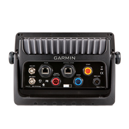
Contents of the package
- GPSMAP 741xs
- Power/data cable
- Bail mount and knobs
- Flush mount kit
- Protective cover
- Documentation
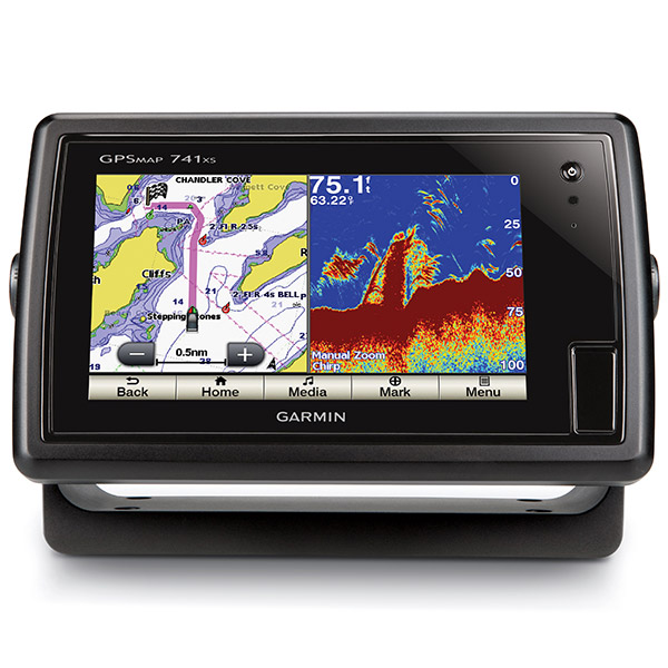
Features
The Garmin GPSMAP 741xs combination chartplotter/sounder features a 7-inch WVGAtouchscreen display with pinch-to-zoom functionality, 60 percent more processing
power than the previous generation, and HD-ID sonar and CHIRP technology. The
built-in high-sensitivity 10 Hz Garmin GPS/GLONASS receiver gives you position and
heading updates 10 times each second and shows fluid vessel movement, dramatically
improving your ability to mark and navigate your way to 5,000 waypoints. The GPSMAP
741xs includes full wireless connectivity, media integration, autopilot
compatibility, radar support and NMEA 2000 connectivity. Oh, and it also comes
preloaded with both US offshore and US lakes cartography.
When you bundle the GPSMAP 741xs with the GMR 18HD Radar with advanced echo pulse
optimizing technology, you can bring higher definition and improved target separation
to your digital radar picture. With 4 kW of power output and a beamwidth of 5
degrees, this compact network compatible 18" radome can scan up to 36 nm.
Powerful
The new GPSMAP combo gives you 60 percent more processing power than the previous
generation, which lets you zoom and pan even faster.
Vivid HD-ID sonar
With Garmins exclusive HD-ID target tracking technology, you get better separation
and definition of images, giving you a clear picture of whats below.
The CHIRP advantage
Youve been waiting for CHIRP technology, and here it is, built into the GPSMAP
741xs. CHRIP sweeps multiple frequencies, allowing better focus on fish at certain
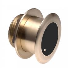
depths. The CHIRP transducer is sold separately.
Capture sonar recording
Sonar recording coordinates the timing of the sonar return with your boat's position
and saves digital information on the map.
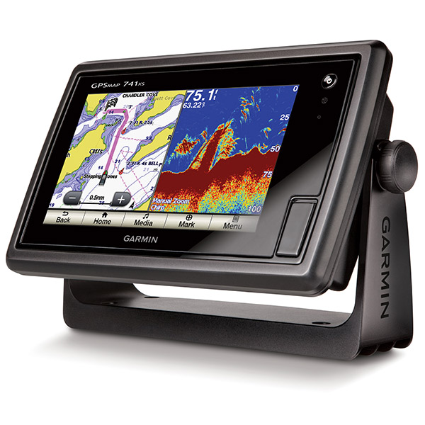
Mount three different ways
You can mount your device with the bail mount, flush mount or flat mount, which means
youll always be able to see your GPSMAP 741xs.
Specifications
Physical & Performance:Unit dimensions, WxHxD: 9.0" x 5.6" x 2.4" (22.9 x 14.2 x 6.1 cm)
Display size, WxH: 6.0" x 3.6", 7.0" diagonal (15.2 x 9.1 cm, 17.8 cm diagonal)
Display resolution, WxH: 800 x 480 pixels
Display type: multi-touch touchscreen WVGA display
Weight: 2.3 lb (1.0 kg)
Waterproof: yes (IPX7)
Maps and Memory:
Basemap: yes
Preloaded maps: yes
Ability to add maps: yes
Accepts data cards: dual microSD card slots
Waypoints/favorites/locations: 5,000
Routes: 100
Track log: 50,000 points; 50 saved tracks
Features and Benefits:
CANet® compatible: no
Supports AIS (tracks target ships' position): yes
Supports DSC (displays position data from DSC capable VHF radio): yes
Audible alarms: yes
Tide tables: yes
Sun and moon information: yes
3-D map view: yes (with optional BlueChart g2 maps)
Dual-frequency sonar capable: yes
Dual-beam sonar capable : yes
Split-screen zoom: yes
Split-screen sonar/gps: yes
Ultrascroll® (displays fish targets at higher boat speeds): yes
See-thru® technology (exposes fish hidden in cover): yes
Fish Symbol ID (helps identify fish targets): yes
AutoGain Technology (minimizes clutter, maximizes targets): yes
Whiteline (indicates hard or soft bottom): yes
Adjustable depth line (measures depth of underwater objects): yes
A-scope (real time display of fish passing through transducer beam): yes
Bottom lock (shows return from the bottom up): yes
Water temperature log and graph: yes
Water temperature sensor included: yes
Other:
Frequency: 25-210 kHz (dependent on transducer)
Transmit power: 1kW (RMS) / 8,000W (peak to peak)
Voltage range: 10V-32V input
Maximum depth: 2,000 ft salt water (depth capacity is dependent on water bottom type and other water conditions)
Additional:
Wi-Fi connectivity: yes
HD-ID tracking technology: yes
Sonar recording: yes
1 video input for onboard camera: yes
Connects to a compatible Fusion media system: yes
Bluetooth® wireless technology: yes
Item number: 010-01102-01
UPC: 753759993863
Package weight: 4.8 lb
Other Products in the Series: