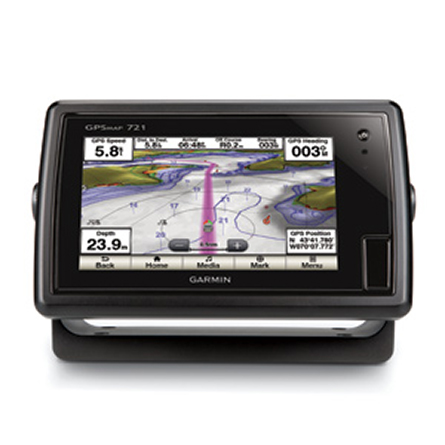
GARMIN Gpsmap 721


GXM 52 - SiriusXM Marine Receiver
GHP 10 Marine Autopilot System with GHC 20
GHP 10V Marine Autopilot System with GHC 20
GHP 20 Marine Autopilot System for Yamaha Helm Master with GHC 10
GHP 20 Marine Autopilot System with SmartPump and GHC 10

GHP 20 Marine Autopilot System for Steer-by-Wire with GHC 10

GHP 20 Marine Autopilot System for Viking with GHC 10

GHP Reactor Hydraulic Autopilot Corepack

GHP Reactor Mechanical Retrofit Solenoid Corepack

GHP Reactor Hydraulic Corepack with SmartPump

GHP Reactor Steer-by-wire Standard Corepack

GHP Reactor Steer-by-wire Corepack for Yamaha Helm Master

GHP Reactor Steer-by-wire Corepack for Viking VIPER

GHP Reactor Steer-by-wire Corepack for Volvo-Penta

GHP Compact Reactor Hydraulic Autopilot Starter Pack


GCV 10 SideVu DownVu CHIRP Scanning Sonar


VHF 300 Black
VHF 300 AIS Black
VHF 100 Black
VHF 100i Black
Vhf 110
VHF 200 Black
VHF 200i Black
VHF 210 AIS Marine Radio
VHF 300i Black
VHF 300i AIS Black


Flush Mount Kit


Flat Mount Kit

SP2S1 rail pod - uncut 11 x 6.125 inch


Panoptix PS31 Forward Transducer
Panoptix PS60 Thru-hull Down Transducer
Panoptix PS21 LiveVu Forward Transducer
Panoptix PS21-TM Forward Transom Mount Transducer


NMEA 2000 Transducer Adapter Kit
GMR 18 xHD Radar
GMR 24 xHD Radar

GMR 18 HD Plus Radar

GMR 424 xHD2 Open Array Radar and Pedestal

GMR 624 xHD2 Open Array Radar and Pedestal

GMR 626 xHD2 Open Array Radar and Pedestal

GMR 1224 xHD2 Open Array Radar and Pedestal

GMR 1226 xHD2 Open Array Radar and Pedestal

GWind, GMI 20, DST800 Bundle


GWind, GMI 20, GNX 20, DST800 Bundle

GWind, GMI 20, DST800, GNX 20 Wireless Bundle


GNX Wind Wired Sail Pack
GWS 10 Wind Sensor
GWS 10 Wind Sensor with GMI 10 Bundle

GWS 10 Wind Sensor with GMI 10 and Smart Triducer Bundle

GWS 10 Wind Sensor with GMI 20 Bundle

GWS 10 Wind Sensor with GMI 20 and DST800 Bundle

GWind, GMI 20, DST800 Wireless Bundle


Meteor 300 Marine Audio System

Meteor 300 Marine Audio System with Speakers
Suggested Maps and Software:
 | Inland Lakes |
 | BlueChart g2, g3 Vision |
 | BlueChart g2, g3 on micro SD card with adapter |
 | Garmin Extras |
 | LakeVu HD Ultra |
 | LakeVu HD |
Contents of the package
- GPSMAP 721
- Power/data cable
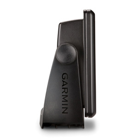
- Bail mount and knobs
- Flush mount kit
- Protective cover
- Documentation
Features
The Garmin GPSMAP 721 chartplotter features a 7-inch touchscreen display and 60percent more processing power than the previous generation, which means faster
zooming and panning. The built-in high-sensitivity 10 Hz Garmin GPS/GLONASS receiver
gives you position and heading updates 10 times each second, and shows fluid vessel
movement, dramatically improving your ability to mark and navigate your way to 5,000
waypoints. The GPSMAP 721 includes full wireless connectivity, media integration,
autopilot compatibility, radar support and NMEA 2000 connectivity. Oh, and it also
comes preloaded with a worldwide basemap.
Powerful
The new GPSMAP combo gives you 60 percent more processing power than the previous
generation, which lets you zoom and pan even faster.
Like a flash
The new GPSMAP 721 features 10 Hz GARMIN GPS, which gives you the upper hand as you
navigate your way back to awesome fishing spots youve marked as a waypoint. The
powerful GPS receiver updates your position 10 times each second, which is 10 times
more often than the 1 Hz GPS found in many devices. As a result, your plotter screen
shows more fluid vessel movement. And, at low speeds, youll have a big advantage.
Mount three different ways
You can mount your device with the bail mount, flush mount or flat mount, which means
youll always be able to see your GPSMAP 721.
Specifications
Physical & Performance:Unit dimensions, WxHxD: 9.0" x 5.6" x 2.4" (22.9 x 14.2 x 6.1 cm)
Display size, WxH: 6.0" x 3.6", 7.0" diagonal (15.2 x 9.1 cm, 17.8 cm diagonal)
Display resolution, WxH: 800 x 480 pixels
Display type: multi-touch touchscreen WVGA display
Weight: 2.1 lb (0.9 kg)
Battery: none
Battery life: none
Waterproof: yes (IPX7)
High-sensitivity receiver: yes
Antenna: internal
NMEA input/output: NMEA 0183 compatible and NMEA 2000® certified
Power consumption: 0.6A at 12V; 0.3A at 24V
0.8A at 12V; 0.4A at 24V (with sonar)
Maps and Memory:
Basemap: yes
Preloaded maps: no
Ability to add maps: yes
Built-in memory: none (cannot load maps to internal memory)
Accepts data cards: dual microSD card slots
Waypoints/favorites/locations: 5,000
Routes: 100
Track log: 50,000 points; 50 saved tracks
Features and Benefits:
Garmin radar compatible: yes
Garmin sonar compatible: no
Garmin Marine Network compatible: no
Touchscreen: yes
Supports AIS (tracks target ships' position): yes
Supports DSC (displays position data from DSC capable VHF radio): yes
Audible alarms: yes
Tide tables: yes
Hunt/fish calendar: no
Sun and moon information: yes
3-D map view: yes (with optional BlueChart g2 Vision card)
Auto Guidance: yes (with optional BlueChart g2 Vision card)
XM WX Weather & Radio for U.S. & Canada compatible: yes
Automatic routing (turn by turn routing on roads): no
Voice prompts (e.g. "Turn right in 500 ft."): no
Speaks street names (e.g. "Turn right ON ELM STREET in 500 ft."): no
Headphone jack/audio line-out: no
Audio/video input/output: no
Portable: no
Automotive/motorcycle-friendly: no
Additional:
Wi-Fi connectivity: yes
HD-ID tracking technology: yes
Sonar recording: yes
Bluetooth® wireless technology: yes
Item number: 010-01101-00
UPC: 753759993832
Package weight: 5.3 lb
Following reviews were written by actual customers.
Every GPS4US customer has a chance to live a feedback after receiving a product.
 by DMITRI P, , 5/14/2016
Very good product, and fast shipping!
Other Products in the Series: