GARMIN GPSMAP 8212 MFD Display Only


This item is brand new
$4,299.95
This item ships within 9 days


GPS 17x NMEA 2000 GPS Receiver
GPS 17x GPS Receiver

GPS 19x NMEA 2000 GPS Receiver

GXM 52 - SiriusXM Marine Receiver
Gdl 30A
GDL 40 Weather Receiver
GXM 51 - Weather and Audio XM Receiver
GHP 10 Marine Autopilot System with GHC 20
GHP 10 Marine Autopilot System with GHC 10

GHP 10V Marine Autopilot System with GHC 10
GHP 10V Marine Autopilot System with GHC 20

GHP 12 Sailboat Autopilot System with GHC 10

GHP 20 Marine Autopilot System for Steer-by-Wire with GHC 10

GHP 20 Marine Autopilot System for Viking with GHC 10
GHP 20 Marine Autopilot System for Yamaha Helm Master with GHC 10
GHP 20 Marine Autopilot System with SmartPump and GHC 10

GHP Reactor Hydraulic Autopilot Corepack

GHP Reactor Mechanical Retrofit Solenoid Corepack

GHP Reactor Hydraulic Corepack with SmartPump

GHP Reactor Steer-by-wire Standard Corepack

GHP Reactor Steer-by-wire Corepack for Yamaha Helm Master

GHP Reactor Steer-by-wire Corepack for Viking VIPER

GHP Reactor Steer-by-wire Corepack for Volvo-Penta

GHP Compact Reactor Hydraulic Autopilot Starter Pack


GSD 26 Digital Sonar
GCV 10 SideVu DownVu CHIRP Scanning Sonar

GSD 22 Digital Sonar


Trim Piece Snap Cover (GRID)

Trim Piece Snap Cover (Card Reader)
Ais 300
Ais 600
VHF 300 Black
VHF 300 AIS Black
VHF 100 Black
VHF 100i Black
VHF 100 Silver Grey
VHF 100i International
Vhf 110
VHF 200 Black
VHF 200i Black
VHF 200 Silver Gray
VHF 200i International
VHF 210 AIS Marine Radio
VHF 300 Silver Gray
VHF 300i International
VHF 300i Black
VHF 300i AIS Black
VHF 300 AIS Silver Gray
VHF 300i AIS International


Surface Mount


Bail Mount (GPSMAP 8012/8212)

SPOD sail pod box uncut for large MFD display


Split Connector 50 ft Right Angle RJ45 Plug


Panoptix PS31 Forward Transducer
Panoptix PS60 Thru-hull Down Transducer
Panoptix PS21 LiveVu Forward Transducer
Panoptix PS21-TM Forward Transom Mount Transducer


NMEA 2000 Transducer Adapter Kit

GNT 10 NMEA 2000 - ANT Transceiver
GMR 18 HD Radar

GMR 604 xHD Open Array and Pedestal

GMR 606 xHD Open Array and Pedestal

GMR 1204 xHD Open Array and Pedestal

GMR 1206 xHD Open Array and Pedestal

GMR 404/406 Radar Pedestal
GMR 404 Open Array Radar
GMR 406 Open Array Radar
GMR 18 Radar

GMR 24 Radar
GMR Fantom 18 Solid-state Radar
GMR Fantom 24 Solid-state Radar
GMR Fantom 4
GMR Fantom 6

GMR 18 HD Plus Radar
GMR 24 HD Radar
GMR 404 xHD Open Array Radar and Pedestal
GMR 406 xHD Open Array Radar and Pedestal

GMR 424 xHD2 Open Array Radar and Pedestal

GMR 624 xHD2 Open Array Radar and Pedestal

GMR 626 xHD2 Open Array Radar and Pedestal

GMR 1224 xHD2 Open Array Radar and Pedestal

GMR 1226 xHD2 Open Array Radar and Pedestal

GBT 10 Bennett Trim Tab Adapter


GC 10 NTSC Marine Camera
GC 10 NTSC Reverse Marine Camera

GWind, GMI 20, DST800 Bundle


GWind, GMI 20, GNX 20, DST800 Bundle

GWind, GMI 20, DST800, GNX 20 Wireless Bundle

9-axis Heading Sensor

GC 12 Marine Camera
GC 10 PAL Marine Camera
GC 10 PAL Reverse Marine Camera
GCL 20 NTSC Low-light Imaging Camera
GCT 20 QVGA 30Hz Thermal Imaging Camera
GCT 30 VGA 9Hz Thermal Imaging Camera
GCL 20 PAL Low-light Imaging Camera
GCT 20 QVGA 9Hz Thermal Imaging Camera
GCT 30 VGA 30Hz Thermal Imaging Camera
Gmi 10


GNX Wind Wired Sail Pack

GWS 10 Wind Sensor with GMI 20 Bundle

GWS 10 Wind Sensor with GMI 20 and DST800 Bundle

GWS 10 Wind Sensor with GMI 10 and Smart Triducer Bundle
GWS 10 Wind Sensor
GWS 10 Wind Sensor with GMI 10 Bundle


GWind Wireless Transducer


GWind, GMI 20, DST800 Wireless Bundle


Airmar Smart Triducer, Plastic Thru, NMEA 2000

Access, Smart Transducer, P39 Transom, Temp, NMEA 2000


DT800 12 tilt NMEA2000 Smart Transducer Plastic


GRID (Remote Input Device)


Meteor 300 Marine Audio System

Meteor 300 Marine Audio System with Speakers
Suggested Maps and Software:
 | Inland Lakes |
 | BlueChart g2, g3 Vision |
 | BlueChart g2, g3 on micro SD card with adapter |
 | Garmin Extras |
 | LakeVu HD Ultra |
 | LakeVu HD |
Contents of the package
- GPSMAP 8212
- Bail mount and knobs
- Protective cover
- Flush mount gasket and hardware
- Power cable
- NMEA 0183 cable
- NMEA 2000 2 m backbone/drop cable
- NMEA 2000 power cable
- NMEA 2000 T-connector & terminator kit
- Manual case with documentation
Features
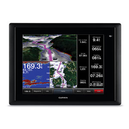
The GPSMAP 8212 is Garmins fully-integrated 12-inch touchscreen multifunctiondisplay (MFD) that gives you an amazing marine user interface. Simply put, the GPSMAP
8212 may be Garmins most technologically-advanced, user-friendly MFD ever.
A touching experience
The GPSMAP 8212 gives you an XGA touchscreen that features pinch-to-zoom technology
and plenty other intuitive touch features. It also comes preloaded with BlueChart g2
maps of the coastal US, including Alaska, Hawaii and the Bahamas, which youll have
no problem reading thanks to the anti-glare and LED backlighting. And, when the sun
goes down, auto-dimming is there to help you out.
Fully integrated
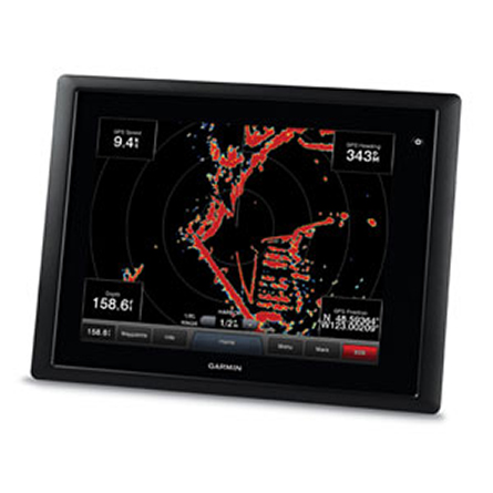
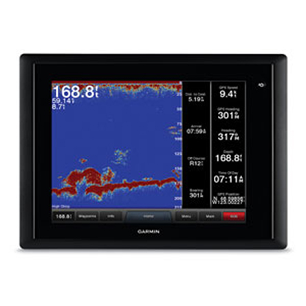
You can use the GPSMAP 8212 with just about everything, including various sonar
technologies, integrated autopilot, connectivity apps, engine data and multi-media.
With SmartMode control, you can switch all monitors in sync from one mode to another
without manually switching each monitor separately. Your GPSMAP 8212 features
customizable layouts, data and gauges to make sure you have all the information you
need, right when you need it.
A high performer
With the external GPS19x smart antenna, which features a 10 Hz GPS/GLONASS receiver,
your GPSMAP 8212 updates your position and heading 10 times each second, showing you
a more fluid vessel movement and giving you easy and accurate navigation to 5,000
waypoints. And the new processor gives you 40 percent more processing power than
previous Garmin series, so your screen will refresh seamlessly when you pan or
navigate.
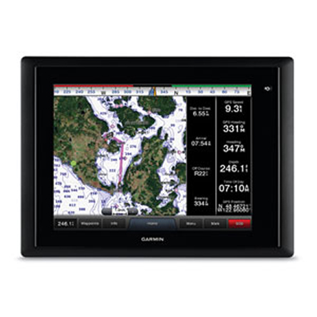
The BlueChart g2 advantage
Your GPSMAP 8212 gives you BlueChart g2 marine maps with vivid labeling and smooth
presentation on your display. Not only do you get basic charts, you also get tidal
stations, currents, depth contours, IALA symbols and included fishing charts.
BlueChart g2 features smooth transitions between zoom levels, and amazing continuity
across chart boundaries. Plus, its covered by Garmins exclusive New Chart Guarantee.
On the GRID
GRID stands for Garmin Remote Input Device, and it gives you full control of all
GPSMAP 8212 Glass Helm series units. It features a rotary knob and joystick controls
that help you navigate through menus and lets you easily toggle between monitors at a
station. You can control multiple monitors with one device. Plus, you can integrate a
small footprint into a captains chair (sold separately).
So many ways to mount
Mount your GPSMAP 8212 with the traditional bail mount or the low-profile flush
mount. But, if you want to really show off your device, try Garmins exclusive
flat-mount glass helm.
Specifications
Physical & Performance:Unit dimensions, WxHxD: 13.1" x 9.7" x 3.8" (33.2 cm x 24.7 cm x 9.6 cm)
Display size, WxH: 9.7" x 7.3", 12.1" diagonal (24.6 x 18.4 cm, 30.7 cm diagonal)
Display resolution, WxH: 1024 x 768 pixels
Display type: Touchscreen XGA display (anti-glare finish)
Weight: 11.4 lb (5.2 kg)
Battery: none
Battery life: none
Waterproof: yes (IPX7)
High-sensitivity receiver: yes
Antenna: GPS19x Smart Antenna
NMEA input/output: 4 NMEA 0183 inputs, 2 NMEA 0183 outputs, 1 NMEA 2000 port
Power consumption: 1.6A at 12V; 0.8A at 24V
Maps and Memory:
Basemap: yes
Preloaded maps: yes (coastal maps)
Ability to add maps: yes
Built-in memory: 64 GB
Accepts data cards: external Garmin Card Reader (accepts SD cards)
Waypoints/favorites/locations: 5,000
Routes: 100
Track log: 50,000 points; 50 saved tracks
Features and Benefits:
Garmin radar compatible: yes
Garmin sonar compatible: yes
Garmin Marine Network compatible: yes
Touchscreen: yes
Supports AIS (tracks target ships' position): yes
Supports DSC (displays position data from DSC capable VHF radio): yes
Audible alarms: yes
Tide tables: yes
Hunt/fish calendar: no
Sun and moon information: yes
3-D map view: yes (with optional BlueChart g2 maps)
Auto Guidance: yes
XM WX Weather & Radio for U.S. & Canada compatible: yes
Automatic routing (turn by turn routing on roads): no
Voice prompts (e.g. "Turn right in 500 ft."): no
Speaks street names (e.g. "Turn right ON ELM STREET in 500 ft."): no
Headphone jack/audio line-out: no
Audio/video input/output: yes
Portable: no
Automotive/motorcycle-friendly: no
Additional:
Interface Inputs/Outputs: 1 House CAN port, 1 Engine CAN port, 4 Garmin Marine Network ports, 2 composite BNC video inputs for onboard cameras, 1 DVI-I monitor video output
Garmin SmartMode compatible: yes
Multi-touch: yes
Series Comparison
| GPSMAP | 8000/8200 | 8400/8600 |
| Full HD widescreen display | | |
| Sunlight readable multi-touch display | | |
| Display type/resolution (pixels) | GPSMAP 8015/8215, XGA - 1024 x 768 GMM 170, SXGA - 1280 x 1024 GMM 190, SXGA - 1280 x 1024 | GPSMAP 8417/8617, WUXGA - 1920 x 1200 GPSMAP 8422/8622, FHD - 1920 x 1080 GPSMAP 8424/8624, WUXGA - 1920 x 1200 |
| Preloaded maps | 8000: Worldwide Basemap 8200: U.S. BlueChart g2 | 8400: Worldwide Basemap 8600: U.S., Canada and Bahamas BlueChart g2 & U.S. LakeVü HD |
| J1939 support | | |
|
Accepts data cards - For optional mapping and user data storage | Requires Garmin Card | Reader Requires Garmin Card Reader (sold separately) |
| Panoptix support | | |
| Network chart sharing | | |
|
Garmin radar compatible - Control radar via GPSMAP display | | |
|
Garmin autopilot compatible - Control autopilot via GPSMAP display | | |
|
Sounder support - GSD 24, 25, 26 and GCV 10 | | |
| Garmin SmartMode controls | | |
|
FUSION-Link support - Control audio via GPSMAP display | | |
| SiriusXM weather & radio compatible | | |
|
Camera support - FLIR thermal cameras - Axis IP cameras | | |
|
Apps - BlueChart Mobile and Garmin Helm | | |
| Wireless connectivity | Wi-Fi (Wi-Fi adapter kit required, sold separately) | Built-in Wi-Fi and ANT |
| NMEA 2000 | | |
| NMEA 0183 | 4 input 2 output | 4 input 2 output |
| Garmin Marine Network | 4 ports | 4 ports |
| Video inputs | 4 BNC composite 1 BNC component 1 DVI-I | 1 BNC composite 1 HDMI (HDCP compliant) Both video sources are shared across the network |
| Video outputs | 1 DVI-I | 1 HDMI |
| Video sharing via marine network | View only | View and share |
| Mounting options | Flat or Flush | Flat or Flush |
Item number: 010-01017-21
UPC: 753759108052
Package weight: 18 lb
Other Products in the Series: