GARMIN Gpsmap 7012


This item is brand new
$2,639.95
This item ships within 3 days


GPS 17x NMEA 2000 GPS Receiver
GPS 17x GPS Receiver

GPS 19x NMEA 2000 GPS Receiver

GXM 52 - SiriusXM Marine Receiver
Gdl 30A
GDL 40 Weather Receiver
GXM 51 - Weather and Audio XM Receiver
GHP 10 Marine Autopilot System with GHC 20
GHP 10 Marine Autopilot System with GHC 10

GHP 10V Marine Autopilot System with GHC 10
GHP 10V Marine Autopilot System with GHC 20

GHP 12 Sailboat Autopilot System with GHC 10

GHP 20 Marine Autopilot System for Steer-by-Wire with GHC 10

GHP 20 Marine Autopilot System for Viking with GHC 10
GHP 20 Marine Autopilot System for Yamaha Helm Master with GHC 10
GHP 20 Marine Autopilot System with SmartPump and GHC 10

GHP Reactor Hydraulic Autopilot Corepack

GHP Reactor Mechanical Retrofit Solenoid Corepack

GHP Reactor Hydraulic Corepack with SmartPump

GHP Reactor Steer-by-wire Standard Corepack

GHP Reactor Steer-by-wire Corepack for Yamaha Helm Master

GHP Reactor Steer-by-wire Corepack for Viking VIPER

GHP Reactor Steer-by-wire Corepack for Volvo-Penta

GHP Compact Reactor Hydraulic Autopilot Starter Pack


GSD 26 Digital Sonar
GSD 22 Digital Sonar


Ais 300
Ais 600
VHF 300 Black
VHF 300 AIS Black
VHF 100 Black
VHF 100i Black
VHF 100 Silver Grey
VHF 100i International
Vhf 110
VHF 200 Black
VHF 200i Black
VHF 200 Silver Gray
VHF 200i International
VHF 210 AIS Marine Radio
VHF 300 Silver Gray
VHF 300i International
VHF 300i Black
VHF 300i AIS Black
VHF 300 AIS Silver Gray
VHF 300i AIS International


Surface Mount


SPOD sail pod box uncut for large MFD display


Split Connector 50 ft Right Angle RJ45 Plug
Panoptix PS21-TM Forward Transom Mount Transducer


NMEA 2000 Transducer Adapter Kit

GNT 10 NMEA 2000 - ANT Transceiver
GMR 18 HD Radar
GMR 18 xHD Radar
GMR 24 xHD Radar

GMR 604 xHD Open Array and Pedestal

GMR 606 xHD Open Array and Pedestal

GMR 1204 xHD Open Array and Pedestal

GMR 1206 xHD Open Array and Pedestal

GMR 404/406 Radar Pedestal
GMR 404 Open Array Radar
GMR 406 Open Array Radar
GMR 18 Radar

GMR 24 Radar

GMR 18 HD Plus Radar
GMR 24 HD Radar
GMR 404 xHD Open Array Radar and Pedestal
GMR 406 xHD Open Array Radar and Pedestal

GMR 424 xHD2 Open Array Radar and Pedestal

GMR 624 xHD2 Open Array Radar and Pedestal

GMR 626 xHD2 Open Array Radar and Pedestal

GMR 1224 xHD2 Open Array Radar and Pedestal

GMR 1226 xHD2 Open Array Radar and Pedestal

GBT 10 Bennett Trim Tab Adapter


GC 10 NTSC Marine Camera
GC 10 NTSC Reverse Marine Camera

GWind, GMI 20, DST800 Bundle


GWind, GMI 20, GNX 20, DST800 Bundle

GWind, GMI 20, DST800, GNX 20 Wireless Bundle

9-axis Heading Sensor

GC 12 Marine Camera
GC 10 PAL Marine Camera
GC 10 PAL Reverse Marine Camera
GCL 20 NTSC Low-light Imaging Camera
GCT 20 QVGA 30Hz Thermal Imaging Camera
GCT 30 VGA 9Hz Thermal Imaging Camera
GCL 20 PAL Low-light Imaging Camera
GCT 20 QVGA 9Hz Thermal Imaging Camera
GCT 30 VGA 30Hz Thermal Imaging Camera
Gmi 10


GNX Wind Wired Sail Pack

GWS 10 Wind Sensor with GMI 20 Bundle

GWS 10 Wind Sensor with GMI 20 and DST800 Bundle

GWS 10 Wind Sensor with GMI 10 and Smart Triducer Bundle
GWS 10 Wind Sensor
GWS 10 Wind Sensor with GMI 10 Bundle


GWind Wireless Transducer


GWind, GMI 20, DST800 Wireless Bundle


Airmar Smart Triducer, Plastic Thru, NMEA 2000

Access, Smart Transducer, P39 Transom, Temp, NMEA 2000


DT800 12 tilt NMEA2000 Smart Transducer Plastic


Meteor 300 Marine Audio System

Meteor 300 Marine Audio System with Speakers
Suggested Maps and Software:
 | Inland Lakes |
 | BlueChart g2, g3 Vision |
 | BlueChart g2, g3 on micro SD card with adapter |
 | Garmin Extras |
 | LakeVu HD |
Contents of the package
Features
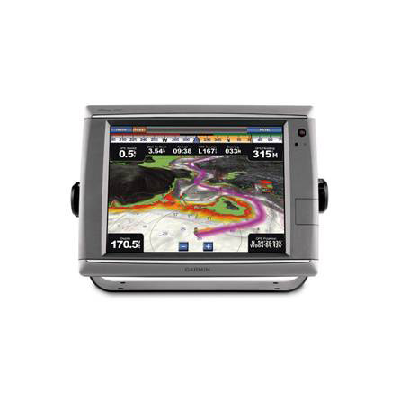
The GPSMAP 7012 touchscreen chartplotter is the flagship of Garmins line of
full-features marine products. You get everything you need to enhance your boats
navigation power. The GPSMAP 7012 comes standard with a worldwide, satellite-enhanced
basemap, along with a giant 12.1-inch XGA display that shows you video-quality
resolution. You also get complete system integration, as the GPSMAP 7012 supports
your additional sonar, radar, weather and more. And, if thats not enough, you can
use the options BlueChart g2 Vision card to add even more features.
The ultimate guide
Garmin G Motion technology means your GPSMAP 7012 is the ultimate navigation machine.
It redraws and refreshes maps at an alarmingly fast rate, so youll be guided by near
real-time data. You can navigate with confidence on the open seas or in a crowded
harbor. Your device also works with an optional remote control and computer mouse,
and it gives you a stylish design that can withstand almost anything Mother Nature
throws at it.
See everything
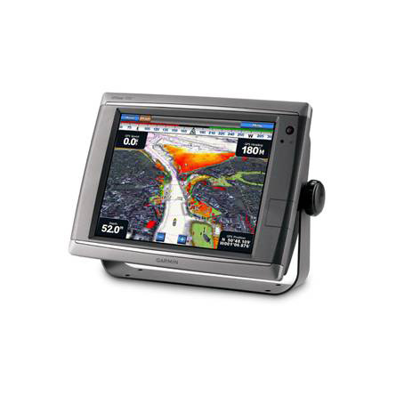
Your GPSMAP 7012s worldwide basemap uses high-quality satellite images instead of
traditional maps. If thats not enough, you can add your own maps with the SD card
slot, all without even connecting to a computer. The GPSMAP 7012 features a
high-speed processor that draws your maps in a flash, and the user-friendly interface
takes the stress out of navigation. You can easily adjust the readability with a
wide-range of brightness options that help make your device perfect for reading in
bright sun or low light. And, if you need to keep an eye on your engine room or any
other part of your boat, use the GPSMAP 7012s input and output feature to connect a
live video feed.
Customize your features
The optional BlueChart g2 Vision card gives you total control of your chartplotters
features.
3D Mariners and Fish Eye view give you a 3D perspective of map information above
and below the surface.
High-resolution satellite images and aerial photographs help you familiarize
yourself in new areas.
Auto Guidance technology searches through all relevant charts to create a route
that avoids obstacles, shallow water, buoys and other obstructions.
Get on the network
The GPSMAP 7012 connects effortlessly to the high-speed Garmin Marine Network. That
means you can interface with additional MFDs, and add remote sensors, high-powered
radar, sonar and XM satellite weather and radio. You can share information between
your GPSMAP 7012 and other chartplotters on your boat.


Specifications
Physical & Performance:
Unit dimensions, WxHxD: 13.3" x 9.9" x 5.8" (33.7 x 25.1 x 14.9 cm)
Display size, WxH: 9.7" x 7.3", 12.1" diagonal (24.6 x 18.4 cm, 30.7 cm diagonal)
Display resolution, WxH: 1024 x 768 pixels
Display type: Touchscreen XGA display
Weight: 15.3 lb (6.9 kg)
Battery: none
Battery life: none
Waterproof: yes (IPX7)
High-sensitivity receiver: yes
Antenna: external
NMEA input/output: NMEA 0183, NMEA 2000
Maps & Memory:
Basemap: yes
Preloaded maps: no
Ability to add maps: yes
Built-in memory: none (cannot load maps to internal memory)
Accepts data cards: SD card slot (BlueChart g2 Vision cards sold separately)
Waypoints/favorites/locations: 5,000
Routes: 100
Track log: 50,000 points; 50 saved tracks
Features:
Garmin radar compatible: yes
Garmin sonar compatible: yes
Garmin Marine Network compatible: yes
Touchscreen: yes
Supports AIS (tracks target ships' position): yes
Supports DSC (displays position data from DSC capable VHF radio): yes
Audible alarms: yes
Tide tables: yes
Hunt/fish calendar: no
Sun and moon information: yes
3-D map view: yes (with optional BlueChart g2 Vision card)
Auto Guidance: yes (with optional BlueChart g2 Vision card)
XM WX Weather & Radio for U.S. & Canada compatible: yes
Automatic routing (turn by turn routing on roads): no
Voice prompts (e.g. "Turn right in 500 ft."): no
Speaks street names (e.g. "Turn right ON ELM STREET in 500 ft."): no
Headphone jack/audio line-out: no
Audio/video input/output: yes
Portable: no
Automotive/motorcycle-friendly: no
Additional: Interface Inputs/Outputs: 4 NMEA 0183 inputs, 2 NMEA 0183 outputs; 2 video inputs for onboard cameras, 1 PC monitor video output
Item number: 010-00749-00
UPC: 753759099350
Package weight: 22 lb
Other Products in the Series: