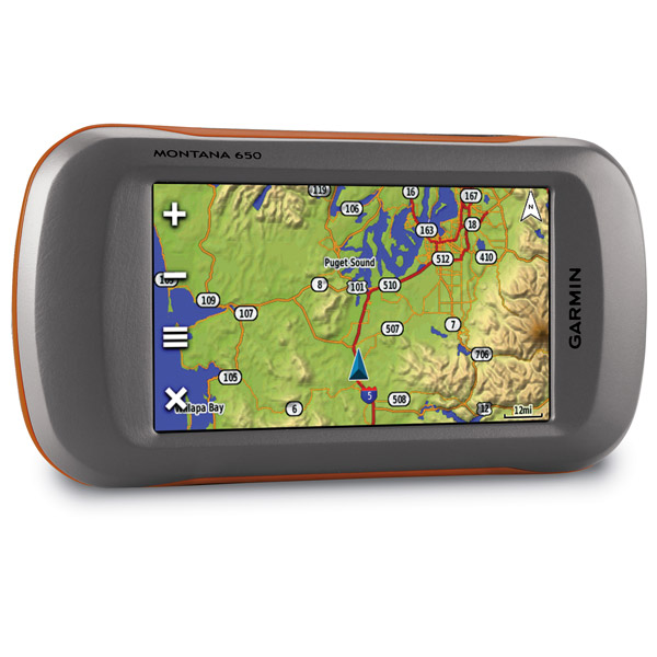
GARMIN Montana 650


GA 25MCX low profile remote GPS antenna


Lithium-Ion Battery Charger

Lithium-Ion Battery Charger


Speed/Cadence bike sensor (GSC 10)
Heart rate monitor

Premium Heart rate monitor Soft Strap

Tempe Wireless Temperature Sensor


HRM-Pro Heart Rate Monitor with Bluetooth and Running Dynamics

HRM-Pro Plus Heart Rate Monitor


Marine Mount with Power Cable


Friction Mount Kit with Speaker


Cup Holder Universal Mount RAM-A-CAN II with 6 in Flex Arm


Chirp Wireless geocaching beacon

BirdsEye Satellite Imagery Retail Card
Virb X
Virb Xe
NOH Virb XE
VIRB XE Cycling Bundle
VIRB XE Auto Racing Bundle
VIRB XE Aviation Bundle
VIRB Ultra 30
VIRB Camera
VIRB Elite Camera Dark
VIRB Elite Camera
BirdsEye Satellite Imagery US and Canada
Suggested Maps and Software:
 | Inland Lakes |
 | BlueChart g2, g3 on micro SD card with adapter |
 | Garmin Street Maps and City Navigation |
 | Garmin Topographic Maps |
 | Garmin Extras |
 | LakeVu HD |
Contents of the package
- Montana 650
- Lithium-ion battery pack
- USB cable
- AC charger
- Quick start manuals
- Owner's manual on disk
Features
No matter what youre doing, if youre outdoors, the Montana 650 will be your guide. The 4-inch color touchscreen has a dual orientation displayand supports several mapping options like BirdsEye Satellite Imagery, and it comes with a 5-megapixel camera. Plus, Montana 650 boasts a 3-axis
tilt-compensated compass and barometric altimeter, so youll always know your altitude and direction. And, when youre using the Montana 650 in
your car with the separate auto mount and City Navigator NT maps, you get spoken turn-by-turn directions.
Crystal clear
Youll see everything with the Montanas 4-inch sunlight-readable touchscreen display. That means vivid colors, and amazing high-resolution
images. The interface is easy to use, so youll spend more time admiring nature and less time with your head buried in your GPS. Of course, the
Montana 650 is waterproof and durable enough to withstand almost anything Mother Nature can throw at it. So no matter if youre on your boat,
RV, ATV or just your hiking boots, the Montana is there for you.
Capture the moment
With the 5-megapixel digital camera, you can capture all the important highlights of your trip. Each photo is automatically geotagged with its
location, so you can always get back to that spot. Your camera gives you the option of portrait or landscape mode. And you can track your photos
on a map by connecting your Montana 650 to your computer with a USB and use Garmins free basecamp software. If you need more storage, dont
worry. Just use a microSD card, which also lets you see pictures from other devices with Montanas picture viewer.
Versatile, just for you
The Montana 650 is compatible with a variety of mounts, so you can use it on your ATV, in your boat, in your car or in your hand. For
turn-by-turn directions in your car, use the auto mount with City Navigator maps. Use the rugged mount for your motorcycle or ATV. Above all,
dont shy away from the terrain. The Montana 650 has the maps and mounts to get you where you need to go.
Customize your maps
Youll have zero problems adding Garmins variety of detailed topographic, marine and road maps to your Montana 650. The microSD card slot makes
sure of that. The load TOPO 24k maps and get going, or insert BlueChart g2 preloaded cards and hit your boat. If youre driving, City Navigator
map data will make your road trip easier. The Montana 650 supports subscription-based BirdsEye Satellite Imagery, so you can download satellite
images and integrate them with your maps. Plus, Montana 650 works with Custom Maps, free software that turns paper and electronic maps into
downloadable gold mines.
Go social
The Montana 650 lets you share routes, tracks, waypoints and geocaches with other compatible Garmin users. Just press send to give your
friends your favorite hikes or caches.
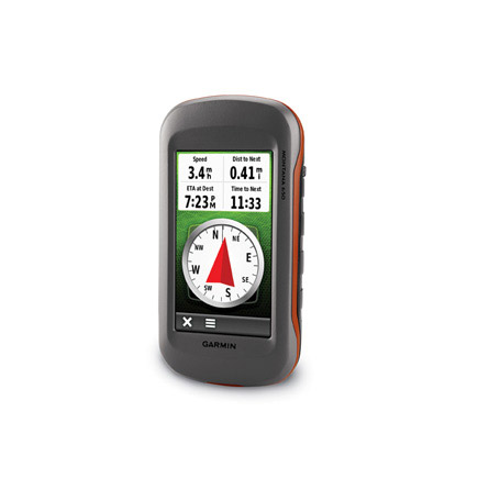
Know where you are
The high-sensitivity, WAAS-enabled GPS receiver and HotFix satellite prediction means the Montana 650 can tell you where you are quickly and
accurately. And, no matter your surrounding terrain, it keeps your fix.
Know your position
With a 3-axis tilt-compensated electronic compass, the Montana 650 shows your heading even when youre not moving or holding it level. Plus, the
barometric altimeter tracks changes in pressure to give you an accurate altitude. You can even use it to plot barometric pressure over time,
which helps you anticipate changes in the weather.
Twice the power
When it comes to batteries, you have options. The Montana 650 features a dual battery system that uses a rechargeable lithium-ion pack or
regular AA batteries.
A geocachers dream
Your Montana 650 supports GPX files, so you can download geocaches to your unit. Just visit OpenCaching.com to start. The Montana stores and
displays key information like difficulty, terrain, hints and descriptions.


Specifications
Installed languages: English,
Spanish, French, Deutsch, Italiano, Portugues, Cesky, Dansk,
Nederlands, Norsk, Suomi, Hrvatski, Magyar, Polski, Russian, Svenska,
Turkse, Latvian, Slovak, Slovenian, Greek, Arabic, Farsi, Bulgarian, Romana.
More languages may be available through Garmin web updater.
Unit dimensions, WxHxD: 2.9" x 5.7" x 1.4" (7.48 x 14.42 x 3.64 cm)
Display size, WxH: 2"W x 3.5"H (5.06 x 8.93 cm); 4" diag (10.2 cm)
Display resolution, WxH: 272 x 480 pixels
Display type: bright, transflective 65k color TFT, dual-orientation touchscreen; sunlight readable
Weight: 10.2 oz (289 g) with included lithium-ion battery pack; 11.7 oz (333 g) with 3 AA batteries (not included)
Battery: rechargeable lithium-ion (included) or 3 AA batteries (not included); NiMH or Lithium recommended
Battery life: up to 16 hours (lithium-ion); up to 22 hours (AA batteries)
Waterproof: yes (IPX7)
Floats: no
High-sensitivity receiver: yes
Interface: high-speed USB and NMEA 0183 compatible
Maps & Memory:
Basemap: yes
Ability to add maps: yes
Built-in memory: 3.0 GB
Accepts data cards: microSD card (not included)
Waypoints/favorites/locations: 2000
Routes: 200
Track log: 10,000 points, 200 saved tracks
Features:
Automatic routing (turn by turn routing on roads): yes (with optional mapping for detailed roads)
Electronic compass: yes (tilt-compensated, 3-axis)
Touchscreen: yes
Barometric altimeter: yes
Camera: yes (5 megapixel with autofocus; automatic geo-tagging)
Geocaching-friendly: yes (paperless)
Custom maps compatible: yes
Photo navigation (navigate to geotagged photos): yes
Outdoor GPS games: no
Hunt/fish calendar: yes
Sun and moon information: yes
Tide tables: yes
Area calculation: yes
Custom POIs (ability to add additional points of interest): yes
Unit-to-unit transfer (shares data wirelessly with similar units): yes
Picture viewer: yes
Garmin Connect compatible (online community where you analyze, categorize and share data): yes
Item number: 010-00924-01
UPC: 753759975753
Package weight: 2 lb
 | Video by GPS4US |
 | Video by GPS4US |
 | Video by GPS4US |
 | Video by GPS4US |
 | Video by GPS4US |
 | Video by GPS4US |
 | Video by GARMIN |
 | Video by Garmin |
View latest videos by GPS4US
Visit GPS4US
 Channel.
Following reviews were written by actual customers.
Every GPS4US customer has a chance to live a feedback after receiving a product.
TOP 20 DISPLAYED
 by Ken M, , 7/31/2015
Really eats batteries, FAST! I use vehicle 12V power, batteries not a problem.
 by Jun Yeong K, , 2/19/2014
Very nice.
by Jun Yeong K, , 2/7/2014Very Nice!
by Atanas P, , 2/13/2013Good product
by EDUARD P, , 9/4/2012excellent
by Cesar F Arriaga G, , 5/15/2012perfec..tk
by Galin P, , 4/16/2012good GPS, very popular among my customers
by Cesar F Arriaga G, , 3/23/2012perfect!
by Galin P, , 1/11/2012This is another Montana i am buying for my friend overseas as it has almost every international language selection and works in Europe out of the box
by matte M, , 12/22/2011really good
by Galin P, , 11/21/2011The Montana is designed to work on the boat, in the car, could be installed on the bike, or serve as handheld GPS navigator for any type of outdoor activity, with universal design and ability to get extended into the voice activated GPS device, it became my primary travel assistant everywhere I go.
by Galin P, , 10/26/2011as always
by Galin P, , 10/21/2011Great GPS, huge screen
by Jozef S, , 10/10/2011The Montana 650 is a bit bulkier and heavier than I expected, but it feels very rugged. The user interface is much improved from earlier Garmin handheld units, as is responsiveness (map panning is quick). GPS4US shipped same day (order placed around 5pm ET).
by POKROVSKY K, , 10/9/2011Отличный навигатор. Основные функции на 5. Из мелких недочетов, все так же плохая камера, нет пешеходной навигации городским транспортом.
by POKROVSKY K, , 10/8/2011Навигатор прекрасный. Жаль, камера стала лучше только на бумаге :(. Грустно что нет навигации общественным транспортом. В остальном все отлично.
by Rune A, , 10/7/2011Excellent and the fastest delivery I have seen!!!Can´t be better!!!
by Barbara T, , 10/7/2011Awesome GPS! (buggy firmware though w/ frequent updates)
by OMAR A, , 10/3/2011ok
by Rick M, , 9/6/2011Great turn around time for shipping!
Read all
Other Products in the Series: