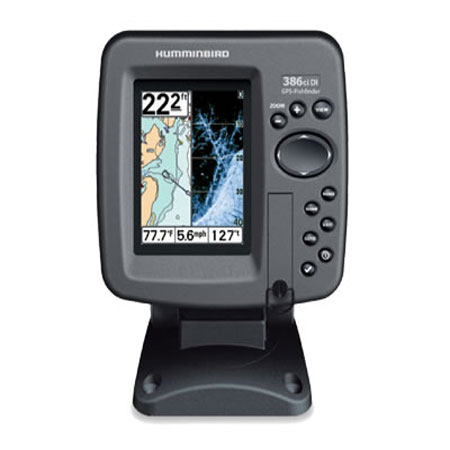
HUMMINBIRD 386ci Combo, 3.5 inch Color, 83/200KHz
Item: 409030-1
This item is brand new
$299.95
This item ships within 8 days


This item is brand new
$299.95
This item ships within 8 days
Cables

720003-1
EC W10 Transducer Ext. Cable, 7 pin, 10 ft
EC W10 Transducer Ext. Cable, 7 pin, 10 ft
No Longer Available

700030-1
AS-HHGPS Handheld GPS Connection Kit
AS-HHGPS Handheld GPS Connection Kit
No Longer Available

720003-2
EC-W30 30 ft Transducer Extension cable
EC-W30 30 ft Transducer Extension cable
No Longer Available
Cases and Covers

406900-1
PTC U Portable Soft Sided Case w/Battery, Charger
PTC U Portable Soft Sided Case w/Battery, Charger
No Longer Available
Mounts


Marine Networking

720002-1
PC10 Power Cable
PC10 Power Cable
No Longer Available
Sensors and Boards

730021-1
SW Speed Sensor, MFG 730021-1, Transom mount, with 20 ft cable
SW Speed Sensor, MFG 730021-1, Transom mount, with 20 ft cable
No Longer Available

730000-1
TS-W Temp/Speed Sensor
TS-W Temp/Speed Sensor
No Longer Available
Transducers Humminbird


710161-1
P72 XPT 9 20 T Depth transducer w temp
P72 XPT 9 20 T Depth transducer w temp
Out of stock

710166-1
XTH 9 20 Depth transducer
XTH 9 20 Depth transducer
No Longer Available

710167-1
XTH 9 20 P Depth transducer
XTH 9 20 P Depth transducer
No Longer Available

710181-1
XFM 9 20 Depth transducer
XFM 9 20 Depth transducer
Out of stock


710214-1
XNT 9 20 Depth Transducer, MFG 710214-1, 83 200KHz, 6020 beam angle
XNT 9 20 Depth Transducer, MFG 710214-1, 83 200KHz, 6020 beam angle
No Longer Available
Other

406900-1NB
PTC U NB Portable Soft Sided Case
PTC U NB Portable Soft Sided Case
No Longer Available
Compatible maps
Suggested Maps and Software:
 | Navionics Marine Charts |
Contents of the package
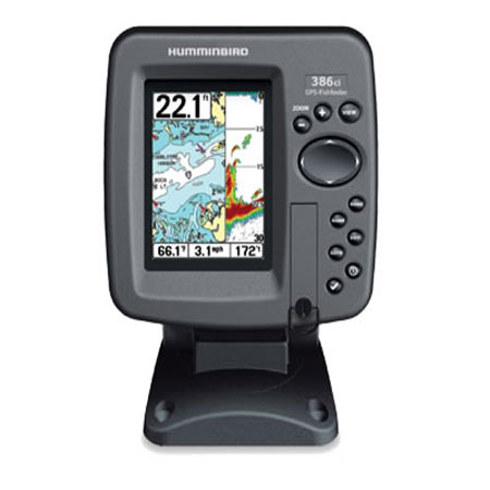
In the box:
- 386ci DI Display
- Mounting bracket
- Transom mount transducer
- Installation hardware
- Owner's manual
Features
Model 386ci Color Fishfinder/Chartplotter with Internal GPSThe 386ci Combo features a brilliant color 320V x 240H 3.5" display with LED backlight, advanced DualBeam sonar with 300 Watts RMS power output, and GPS Chartplotting with built-in UniMap. OPTIONAL: Navionics® Gold/HotMaps | LakeMaster
Humminbird UniMap
The built-in UniMap covers the contiguous U.S.A. coastline and inland lakes and rivers at 30 meters per pixel resolution. On the coast, this clearly shows features as small as canals, and many coastal navigation lights. Inland, the UniMap features virtually all recreational lakes and rivers, plus hundreds of thousands of small lakes that dont appear on other charts. In other words, your lake is likely to be there! The detail of these charts can be seen right on this page. With the UniMap, you have a chart virtually anywhere you travel in the United States.
Advanced Sonar Features
- Switchfire Sonar
- Real Time Sonar RTS Window
- Instant Image update
- Selective Fish ID
- Sonar Echo Enhancement
- Split Screen Zoom
- TrueArch technology
- Wide/narrow cone split screen
- Custom Digital Readout Selection
- Custom View Selections
- Large Digits View
- Selectable background
- Temperature alarm
- Triplog
- X Press Menu System
Specifications
Display3.5" diag. color LCD
Resolution
320 x 240 pixels
Dimensions
5.25"W x 7.4"H x 4"D
Mapping
Built-in UniMap, optional Navionics Gold/HotMaps, LakeMaster
Antenna
Internal GPS antenna included
Waypoints/Routes
2,500 waypoints, 50 routes, 20,000 trackpoionts, 50 saved tracks
Frequency
83/200 KHz dual beam
Power
500 Watts
Transducer
Transom mount transducer included
Interface
NMEA 0183 in/out
Other Functions
None
Warranty
One Year
Item number: 409030-1
UPC: 082324038532
Package weight: 4 lb
Other Products in the Series: