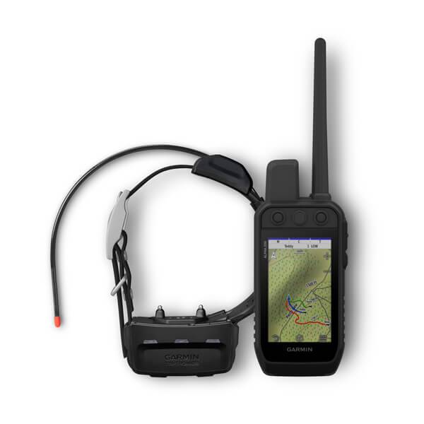
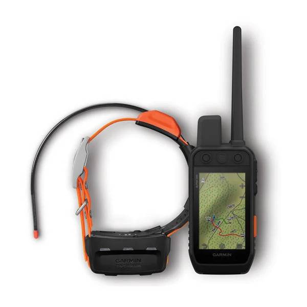
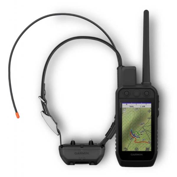
GARMIN Alpha 200 and TT 15X Dog Tracking and Training Bundle TT15X


Item: 010-02616-5TT15
This item is brand new
$1,049.99
This item ships within 1 day
st


This item is brand new
$1,049.99
This item ships within 1 day
st
Adapters Chargers


Antennas


010-10856-60
VHF antenna (2-pack)
VHF antenna (2-pack)
Out of stock


Batteries


Cables

Cases and Covers


Kits


Memory


Mounts


RAM Mounts Build your own


RAP-299-2U
Cup Holder Universal Mount RAM-A-CAN II with 6 in Flex Arm
Cup Holder Universal Mount RAM-A-CAN II with 6 in Flex Arm
No Longer Available


Straps, Holsters, Clips


013-00052-00
Lanyard 17 inch
Lanyard 17 inch
No Longer Available


010-12897-01
Carabiner clip
Carabiner clip
Out of stock

010-12668-02
Lanyard Carabiner
Lanyard Carabiner
Out of stock
T 5 Collars


Alpha TT 25 Collars


T 5X Collars


Alpha T 20 Collars


TT 15 Collars

TT 15X Collars

Other

010-11092-20
Chirp Wireless geocaching beacon
Chirp Wireless geocaching beacon
Out of stock

010-11543-00
BirdsEye Satellite Imagery Retail Card
BirdsEye Satellite Imagery Retail Card
No Longer Available

010-01363-01
Virb X
Virb X
Out of stock
010-01363-11
Virb Xe
Virb Xe
No Longer Available
010-01363-11
NOH Virb XE
NOH Virb XE
Out of stock

010-01529-03
VIRB Ultra 30
VIRB Ultra 30
No Longer Available
010-01363-20
VIRB XE Cycling Bundle
VIRB XE Cycling Bundle
No Longer Available
010-01363-40
VIRB XE Auto Racing Bundle
VIRB XE Auto Racing Bundle
No Longer Available
010-01363-30
VIRB XE Aviation Bundle
VIRB XE Aviation Bundle
No Longer Available
010-01088-00
VIRB Camera
VIRB Camera
No Longer Available
010-01088-15
VIRB Elite Camera Dark
VIRB Elite Camera Dark
No Longer Available
010-01088-10
VIRB Elite Camera
VIRB Elite Camera
No Longer Available
010-11753-00
BirdsEye Satellite Imagery US and Canada
BirdsEye Satellite Imagery US and Canada
No Longer Available

010-01696-00
DriveTrack 70LMT
DriveTrack 70LMT
No Longer Available

010-01982-00
DriveTrack 71
DriveTrack 71
Out of stock

010-02133-00
Montana 700
Montana 700
No Longer Available

010-02347-10
Montana 700i
Montana 700i
Out of stock

010-02347-00
Montana 750i
Montana 750i
No Longer Available
Compatible maps
Also available


Suggested Maps and Software:
 | Inland Lakes |
 | BlueChart g2, g3 on micro SD card with adapter |
 | Garmin Street Maps and City Navigation |
 | Garmin Topographic Maps |
 | Garmin Extras |
Contents of the package
Alpha 200 010-02616-50
Alpha 200 handheld with a rechargeable Li-ion battery pack
Belt clip
AC adapter
microUSB cable
Documentation
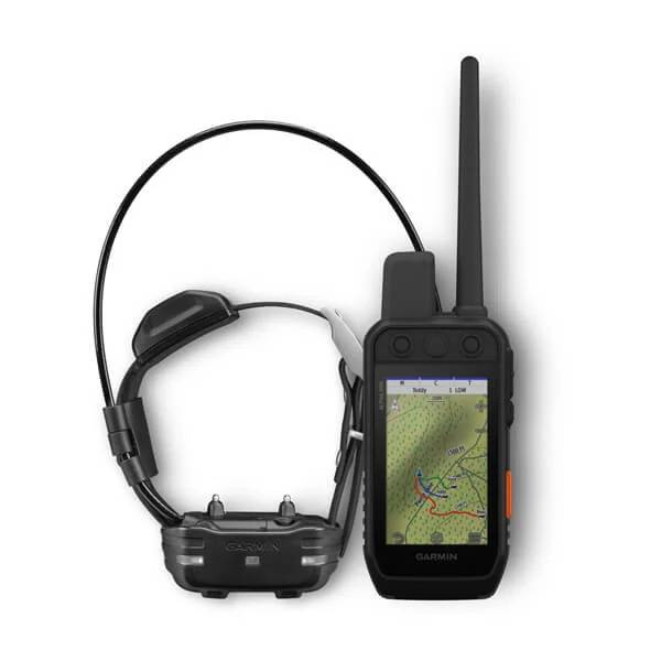
TT15X 010-02755-80
TT 15X dog collar with a rechargeable Li-ion battery pack
18.5" standard antenna
AC adapter
Vehicle power cable
Charging cable
Contacts kit
Documentation
Alpha 200 handheld with a rechargeable Li-ion battery pack
Belt clip
AC adapter
microUSB cable
Documentation
TT15X 010-02755-80
TT 15X dog collar with a rechargeable Li-ion battery pack
18.5" standard antenna
AC adapter
Vehicle power cable
Charging cable
Contacts kit
Documentation
Features
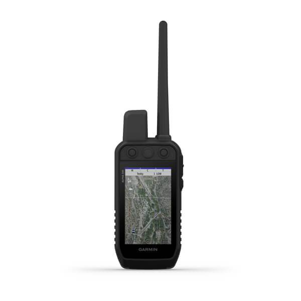
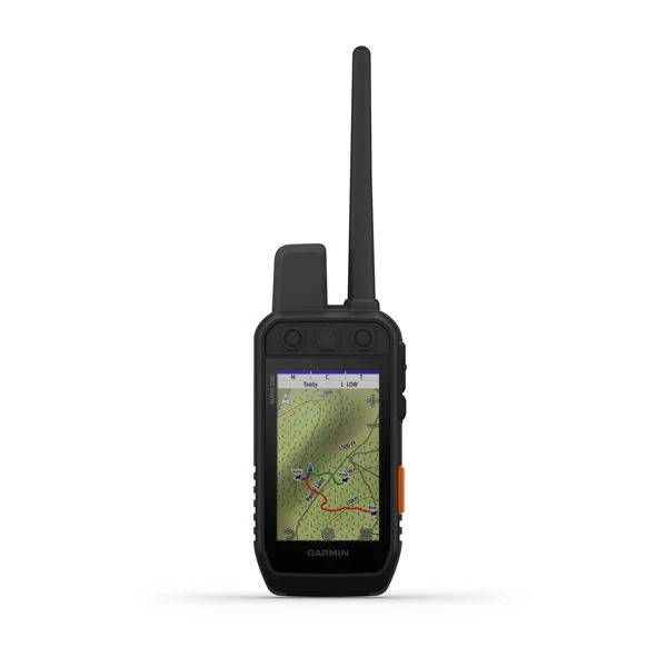
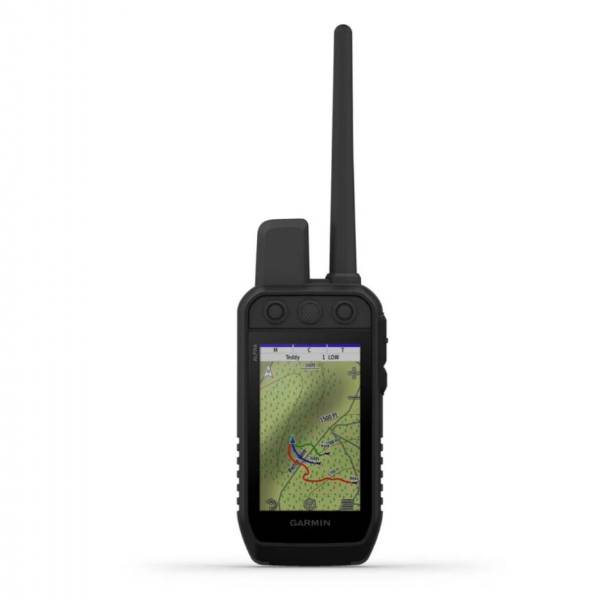
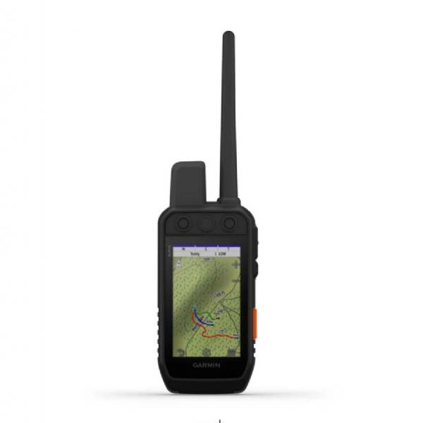
Track and train your dogs with the Alpha 200 handheld, featuring a sunlight-readable 3.5 capacitive touchscreen and user-friendly six-button design1.This handheld is designed to help make tracking and training simple, accessible and fast.
Track and train your pack while theyre out in the field.
Keep inactive dogs in the system for easier setup and management.
Navigate every hunt with the best in Garmin mapping and sensors.
User-replaceable battery lasts up to 20 hours.
Take dog tracking and training to the next level.
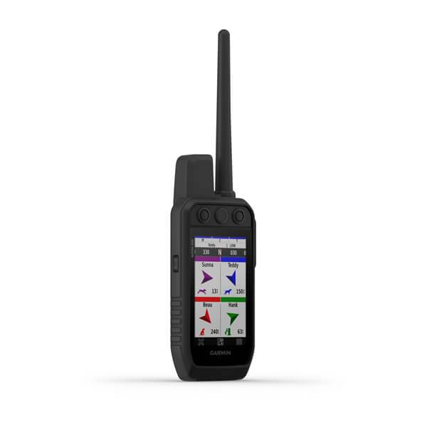
TRACK YOUR PACK
Monitor up to 20 dogs with your compatible dog collars from up to 9 miles with a 2.5-second update rate.
DOG LIST/GROUP MANAGEMENT
Keep inactive dogs in your dog list, and manage active groups so you dont have to add and remove dogs for every hunt1.
PUBLIC LAND BOUNDARIES
Optional display of public land boundaries on topographical maps helps you know that youre venturing where youre supposed to be.
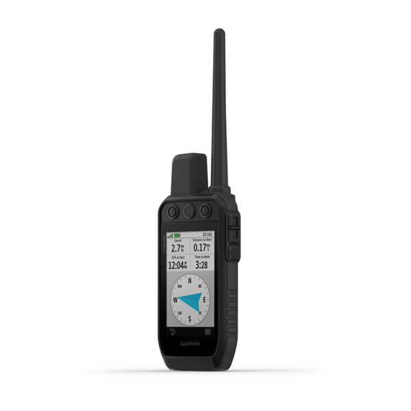
HUNT METRICS
See each dogs daily hunting patterns, distance and speed so you can monitor performance and help prevent overheating. Pair with compatible Garmin dog collars (sold separately).
SIX-BUTTON DESIGN
Use dedicated buttons for fast training cues and minor adjustments in the field.
18 LEVELS OF STIMULATION
Momentary and continuous stimulation options let you customize training for each dog when used with a compatible training enabled collar.
TONE/VIBRATION
Issue different levels of audible tone or vibration commands for quick adjustments to individual dogs when used with a compatible training enabled collar.
GARMIN EXPLORE APP
Pair with the Garmin Explore smart-device app to see real-time dog tracking information, save collections of dog tracks and replay tracks to see exactly what happened during your hunt.
PRO VIEW COMPASS
The pro view compass mode gives you simple, at-a-glance tracking that shows which direction and how far away your dogs are, plus you will see when a dog is Treed or OnPoint.
MULTI-GNSS SUPPORT
Access multiple global navigation satellite systems (GPS and Galileo) to track your pack with greater accuracy than GPS alone.
TOPOACTIVE MAPS
Our preloaded TopoActive mapping provides detailed views of terrain contours, topographic elevations, summits, parks, coastlines, rivers, lakes and geographical points.
BIRDSEYE DIRECT
Download BirdsEye Satellite Imagery directly to the handheld via Wi-Fi® connectivity for better-than-real-life views of your route, trailheads, clearings and more.
NAVIGATION SENSORS
A barometric altimeter helps you accurately monitor ascent and descent and see short-term trends in air pressure, and the built-in tilt-compensated 3-axis electronic compass keeps your bearing whether youre moving or not.
SEE IT ALL
The sunlight-readable 3.5 capacitive touchscreen display makes it easy to see and interact with your maps, dog data and more even while wearing gloves.
STAY ON THE MOVE
The replaceable battery lasts up to 20 hours, giving you plenty of hunt time with your dogs in the field.
ADDITIONAL MAPPING
The microSD card slot allows you to load more mapping options, such as TOPO U.S. 24K and HuntView maps (each sold separately).
IN-VEHICLE TRACKING
If youre using a vehicle to follow and retrieve your dogs, the rugged Tread® off-road powersport navigator or Garmin DriveTrack 71 car navigator (each sold separately) provide an easy-to-watch big picture solution. The moving map display shows dog positions overlaid on TOPO contours or satellite image views along with navigation cues that help point you to your dogs current location.
1 Requires compatible dog collars (sold separately)
Specifications
GeneralDIMENSION 2.7 x 6.4 x 1.3 (6.8 x 16.2 x 3.4 cm) *dimensions do not include antenna
TOUCHSCREEN
DISPLAY SIZE 1.8" W x 3.0" H (4.7 x 7.7 cm); 3.5" diag (88.9 mm)
DISPLAY RESOLUTION 282 x 470 pixels
DISPLAY TYPE transflective, color TFT touchscreen
WEIGHT 9.9 oz (280 g) with standard antenna and battery
BATTERY TYPE rechargeable lithium-ion (included)
BATTERY LIFE up to 20 hours
WATERPROOF IPX7
INTERFACE high-speed USB
MEMORY/HISTORY 16 GB
Maps & Memory
PRELOADED MAPS
yes (TopoActive)
ABILITY TO ADD MAPS
BASEMAP
AUTOMATIC ROUTING (TURN BY TURN ROUTING ON ROADS) FOR OUTDOOR ACTIVITIES Yes (with optional mapping for detailed roads)
BIRDSEYE yes, direct to device (no annual subscription required)
EXTERNAL MEMORY STORAGE microSD card (not included)
WAYPOINTS/FAVORITES/LOCATIONS 10000
TRACKS up to 20 dogs (TT and T series collars) and buddies (Alpha 100 and Alpha 200) simultaneously
NAVIGATION TRACK LOG 20,000 points, 200 saved gpx tracks, 300 saved fit activities
NAVIGATION ROUTES 250
STORED CONTACTS 250 dogs
GROUP MANAGEMENT
Sensors
HIGH-SENSITIVITY RECEIVER
BAROMETRIC ALTIMETER
COMPASS Yes (tilt-compensated 3-axis)
Outdoor Recreation
SUN AND MOON INFORMATION
CUSTOM MAPS COMPATIBLE
Two-way Radio Features
FREQUENCY BAND MURS
RANGE TT and T series, 9 miles; TT mini and T mini series, 4 miles
Outdoor Applications
COMPATIBLE WITH GARMIN EXPLORE APP
GARMIN EXPLORE WEBSITE COMPATIBLE
Connections
CONNECTIONS WIRELESS CONNECTIVITY
yes (Wi-Fi®, BLUETOOTH® and ANT+®)
Item number: 010-02616-5TT15
UPC: 753759294786
Package weight: 5.2 lb
Other Products in the Series:
 | GARMIN Alpha 10 Handheld only | Add to comparison |
 | GARMIN Alpha 200 and TT 15 Mini Dog Tracking and Training Bundle TT15 | Add to comparison |
 | GARMIN Alpha 200 Handheld and TT 25 Dog Tracking and Training Collar | Add to comparison |
 | GARMIN Alpha 200 Handheld GPS, Refurbished, LIMITED FUNCTIONALITY - Training only NOH | |
| GARMIN Alpha 200 Handheld only | Add to comparison |
| GARMIN Alpha 200 Plus Handheld only | Add to comparison |
 | GARMIN Alpha 200i and T 5 mini Dog Tracking Bundle T5 mini | |
 | GARMIN Alpha 200i and T 5X Dog Tracking Bundle T5X | Add to comparison |
 | GARMIN Alpha 200i and TT 15 mini Dog Tracking and Training Bundle TT15 mini | Add to comparison |
 | GARMIN Alpha 200i and TT 15X Dog Tracking and Training Bundle TT15X | |
 | GARMIN Alpha 200i Handheld only | Add to comparison |
 | GARMIN Alpha 300 Handheld and TT 25 Dog Tracking and Training Collar | Add to comparison |
 | GARMIN Alpha 300 Handheld only | Add to comparison |
 | GARMIN Alpha 300i with inReach Handheld only | Add to comparison |
 | GARMIN Alpha XL | Add to comparison |