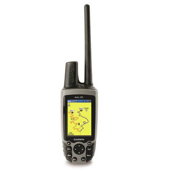
GARMIN Astro 320 with Hard Carrying Case


VHF antenna (2-pack)


Field Bag


Back Casing Cover for Astro 320 repairs
Gasket Seal for Astro casing


Cup Holder Universal Mount RAM-A-CAN II with 6 in Flex Arm


Lanyard 17 inch


Lanyard Carabiner
DC 50 Blue GPS Dog Tracking Collar with 90 day wty


Chirp Wireless geocaching beacon

BirdsEye Satellite Imagery Retail Card
Virb X
Virb Xe
NOH Virb XE

VIRB Elite Camera Dark
VIRB XE Cycling Bundle
VIRB XE Auto Racing Bundle
VIRB XE Aviation Bundle
VIRB Ultra 30
VIRB Elite Camera
DC 20 GPS Dog Tracking Transmitter with Harness
BirdsEye Satellite Imagery US and Canada

DC 40 GPS Dog Tracking Collar

DriveTrack 71

Montana 700

Montana 700i

Montana 750i


Suggested Maps and Software:
 | Inland Lakes |
 | BlueChart g2, g3 on micro SD card with adapter |
 | Garmin Street Maps and City Navigation |
 | Garmin Topographic Maps |
 | Garmin Extras |
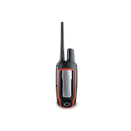
Contents of the package
- Astro 320
- Extended range antenna
- USB cable
- Carabiner clip
- Manuals
- Hard plastic carrying case
Features
Want to know where your dog is? Well, the Astro 320 dog tracking system will tell you, pinpointing your dogs location. It doesnt matter if you cant see or hear your dog, youll know its exact location on your Astro 320. Hunters, you have Garmins ear. Thats why the Astro 320 has so many features youve been asking for, including increased range, a simplified user interface and mapping capability.Further, your Astro 320 comes with 12 languages installed, including English, Spanish, French, Deutsch, Italiano, Portugues, Dansk, Norsk, Suomi, Russian, Svenska and Greek.
Know your dogs location
With the Astro system, you get the redesigned Astro 320 handheld and the DC 40 and DC 50 transmitter collar. Because the DC 40 or DC 50 works with most e-collar receivers, you wont need to put more than one collar on your dog. The DC 40's and DC 50's Collar Lock lets you create a 4-digit PIN number that prevents others from tracking your dog.
And its easy to get started. Just take your Astro outside, turn on the handheld and transmitter to acquire GPS satellite signals, and attach the DC 40 or DC 50 to your dogs.
An improved Astro
Dog tracking takes a giant step forward with the intuitive Astro. New features like enhanced map drawing, subscription-based BirdsEye Satellite Imagery capability, vibrating alerts and a 3-axis tilt-compensated compass make Astro easier to use.
And, with the redesigned antenna, your maximum dog tracking range increases nearly 30 percent, up to 9 miles in flat, unobstructed terrain.
The Astro 320 is compatible with any Garmin DC series transmitter. Plus, your Astro 320 can stand up to the weather. Whether its dust, dirt, humidity or water, its no match for this perfect hunting tool.
An easy upgrade
Now, you can easily take care of your hunting needs. You can purchase the entire Astro bundle or as many collars as you need. And your Astro 320 works with every DC series collar.
Get all the mapping you need
Astro 320s microSD card slot lets you buy and load TOPO US 24K maps for land elevation contours or City Navigator NT map data. With your Astro 320, you can also use subscription-based BirdsEye Satellite Imagery, allowing you to download satellite images and integrate them with your maps. With all of this mapping technology, youll know immediately if your dog has crossed a creek or is nearing a dangerous road.
Astro 320 is also compatible with Garmin Custom Maps, the free software that allows you to download maps into your unit.
A powerful dog tracking tool
The DC 40 transmits your dogs location as often as every 5 seconds, so youll always know where he is. The Dog Tracker page shows you a compass pointing to your dogs location and his current status, whether running, standing, or treeing quarry. Astro can instantly sound an alarm if your dog goes on point.
The Astro 320s map page also shows your dogs precise distance, and you can auto zoom the map so you can see the location of all of your dogs at any time. If your dog is out of range, youll see it notated in the display margin. You can also choose how long the map displays each dogs location, or turn it off completely for a less cluttered display.
The Astro 320 possesses a high-sensitivity GPS receiver that can track up to 10 dogs at once from up to 9 miles away, depending on terrain. Youll get information by line-of-sight, so it reaches farthest in flat, open terrain.
Count your coveys
Use Astros Covey Counter to mark the spot you captured your game. Covey Counter tells you the exact location, time and elevation where you found your quarry, and tells you how many birds you flushed and took from that location. You can also use your Astro 320 to mark other special waypoints, such as Truck and Lodge. Astro gives you special waypoint icons to represent food plots, tree stands and other hunting-related points of interest.
Specifications
Physical & Performance:
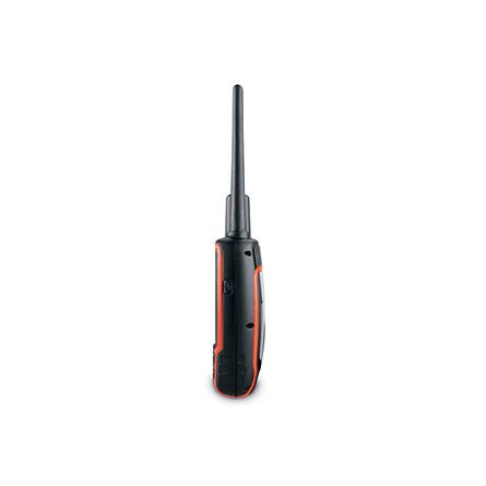
Unit dimensions, WxHxD: 2.4" x 6.3" x 1.4" (6.1 x 16.0 x 3.6 cm)
Display size, WxH: 1.6" x 2.2" (4.1 x 5.6 cm); 2.6" diag (6.6 cm)
Display resolution, WxH: 160 x 240 pixels
Display type: transflective, 65-K color TFT
Weight: 9.2 oz (260.1 g) with batteries
Battery: 2 AA batteries (not included); NiMH or Lithium recommended
Battery life: up to 20 hours
Waterproof: yes (IPX7)
Floats: no
High-sensitivity receiver: yes
Interface: USB
Maps & Memory:
Basemap: yes
Ability to add maps: yes
Built-in memory: 1.7 GB
Accepts data cards: microSD card (not included)
Waypoints/favorites/locations: 2000
Routes: 200
Track log: 10,000 points, 200 saved tracks
Features:
Automatic routing (turn by turn routing on roads): yes (with optional mapping for detailed roads)
Electronic compass: yes (tilt-compensated, 3-axis)
Touchscreen: no
Barometric altimeter: yes
Camera: no
Geocaching-friendly: yes (paperless)
Custom maps compatible: yes
Photo navigation (navigate to geotagged photos): yes
Outdoor GPS games: no
Hunt/fish calendar: yes
Sun and moon information: yes
Tide tables: yes
Area calculation: yes
Custom POIs (ability to add additional points of interest): yes
Unit-to-unit transfer (shares data wirelessly with similar units): yes
Picture viewer: no
Garmin Connect compatible (online community where you analyze, categorize and share data): yes
Additional: Range: DC-40, DC-50: 9 miles (line of sight)
Frequency band: MURS
Vibration mode: yes
Tracks up to 10 dogs simultaneously
Item number: 010-00976-1C
UPC: 753759975951
Package weight: 5 lb
 | Video by GPS4US |
 | Video by GPS4US |
 | Video by GPS4US |
 | Video by GPS4US |
 | Video by GPS4US |
 | Video by GPS4US |
 | Video by GPS4US |
 | Video by GPS4US |
 | Video by GPS4US |
View latest videos by GPS4US
Visit GPS4US
 Channel.
Following reviews were written by actual customers.
Every GPS4US customer has a chance to live a feedback after receiving a product.
 by Andrew K, , 6/11/2014
Really good product. Thank you for the quick postage
by mike K, , 12/31/2012Would recommend
by FAURE G, , 8/20/2012produit tres performant rapport qualite prix:excellent;livraison tres rapide.
by ä¿æ¬¡ Å, , 1/11/2012good
Other Products in the Series:
| GARMIN Astro 220 bundle (Astro 220 and DC 30) | Add to comparison |
| GARMIN Astro 220 bundle (Astro 220 and DC 40) | Add to comparison |
 | GARMIN Astro 220, no battery cover NOH | Add to comparison |
| GARMIN Astro 320 and DC 30 Bundle | Add to comparison |
| GARMIN Astro 320 and DC 40 Bundle | Add to comparison |
| GARMIN Astro 320 and DC 50 Bundle with 90 day wty | |
| GARMIN Astro 320 and T 5 mini Bundle T5 | |
 | GARMIN Astro 320 Pre-owned | Add to comparison |
| GARMIN Astro 320 T5 Orange T 5 Bundle | |
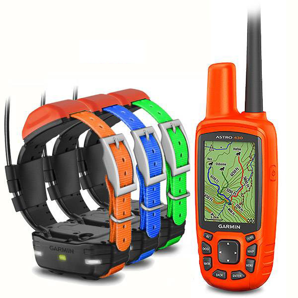
| GARMIN Astro 430 and 2 x T5 Collars Bundle | |
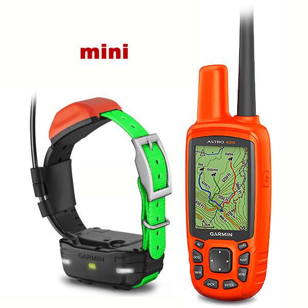
 | GARMIN Astro 430 and 2 x T5 mini Collars | Add to comparison |
| GARMIN Astro 430 and 3 x T5 Collars Bundle | |
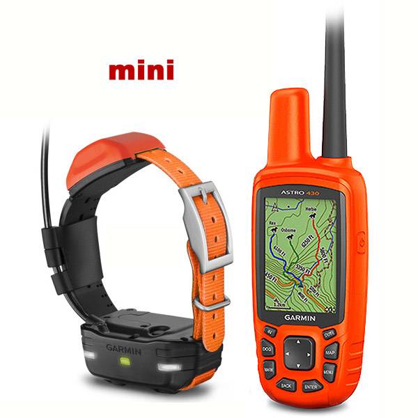
 | GARMIN Astro 430 and 3 x T5 mini Collars | Add to comparison |
| GARMIN Astro 430 and 4 x T5 Collars Bundle | |
| GARMIN Astro 430 and 5 x T5 Collars Bundle | |
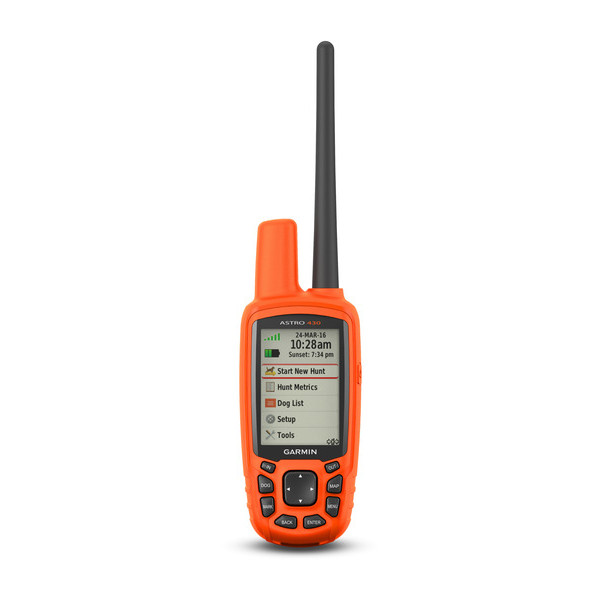 | GARMIN Astro 430 Handheld Only | Add to comparison |
| GARMIN Astro 430 Handheld Only, Pre-owned | Add to comparison |
| GARMIN Astro 430 Handheld, Refurbished NOH | Add to comparison |
| GARMIN Astro 430 Handheld, Used, no accessories NOH | |
| GARMIN Astro 430 Refurbished and T5 mini Dog Tracking Bundle T 5 NOH | Add to comparison |
| GARMIN Astro 430 Refurbished T5 mini Dog Tracking, Basic Accessories Bundle NOH | Add to comparison |
 | GARMIN Astro 430 T5 Black Dog Tracking Bundle T 5 | |
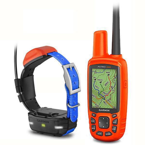
 | GARMIN Astro 430 T5 Blue Dog Tracking Bundle T 5 | |
 | GARMIN Astro 430 T5 Blue Dog Tracking Bundle T 5 Refurbished NOH | |
 | GARMIN Astro 430 T5 Blue Dog Tracking, Refurbished, Basic Accessories Bundle NOH | |
| GARMIN Astro 430 T5 Blue Dog Tracking, Refurbished, Warranty replacement Service NOH | |
 | GARMIN Astro 430 T5 Burgundy Dog Tracking Bundle T 5 | |
 | GARMIN Astro 430 T5 Dark Green Dog Tracking Bundle T 5 | |
 | GARMIN Astro 430 T5 Gray Dog Tracking Bundle T 5 | |
 | GARMIN Astro 430 T5 Light Green Dog Tracking Bundle T 5 | |
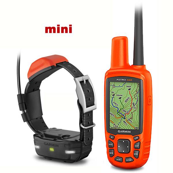 | GARMIN Astro 430 T5 mini Black T 5 Bundle | Add to comparison |
 | GARMIN Astro 430 T5 mini Blue T 5 Bundle | Add to comparison |
 | GARMIN Astro 430 T5 mini Light Green T 5 Bundle | Add to comparison |
 | GARMIN Astro 430 T5 mini Orange T 5 Bundle | Add to comparison |
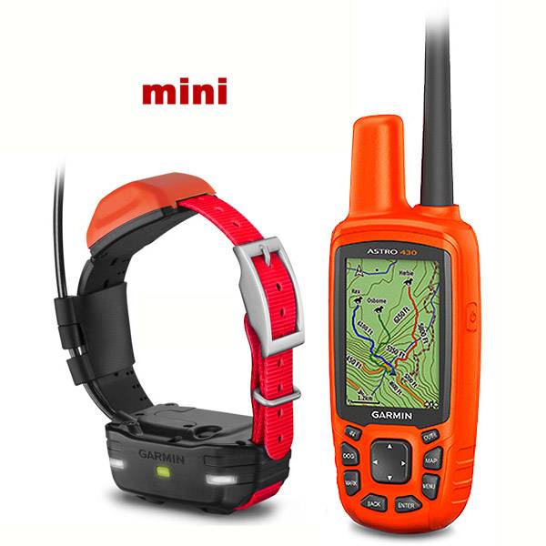 | GARMIN Astro 430 T5 mini Red T 5 Bundle | Add to comparison |
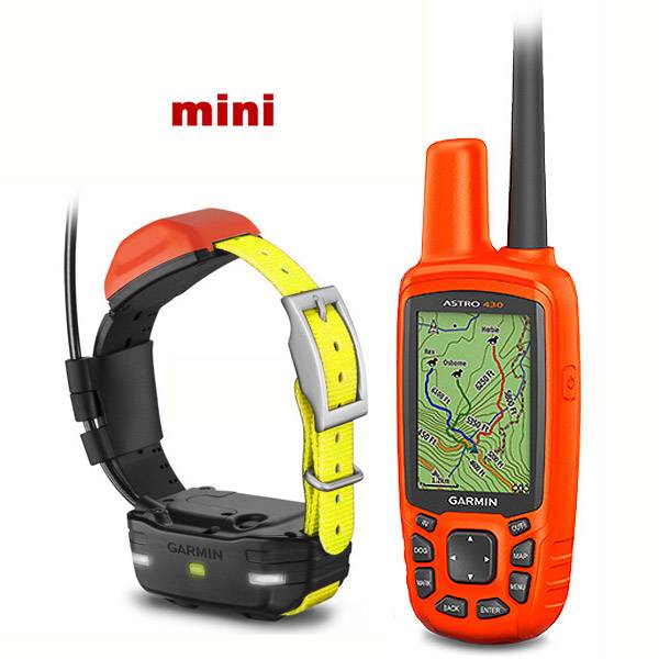 | GARMIN Astro 430 T5 mini Yellow T 5 Bundle | Add to comparison |
 | GARMIN Astro 430 T5 Orange Dog Tracking Bundle T 5 | |
 | GARMIN Astro 430 T5 Pink Dog Tracking Bundle T 5 | |
 | GARMIN Astro 430 T5 Purple Dog Tracking Bundle T 5 | |
 | GARMIN Astro 430 T5 Red Dog Tracking Bundle T 5 | |
 | GARMIN Astro 430 T5 White Dog Tracking Bundle T 5 | |
 | GARMIN Astro 430 T5 Yellow Dog Tracking Bundle T 5 | |
 | GARMIN Astro 430 T5 Yellow School Bus Dog Tracking Bundle T 5 | |
| GARMIN Astro bundle (Astro 220 and DC 20) NOH | |
| GARMIN DC 20 GPS Dog Tracking Transmitter with Harness | Add to comparison |
| GARMIN DC 30 GPS Dog Tracking Collar, Without Accessories NOH | |
 | GARMIN USED Astro 430 T5 Blue Dog Tracking, Refurbished, Used, no Accessories Bundle NOH | |
 | GARMIN Xero C1 Pro Chronograph | Add to comparison |
| GARMIN Xero C2 Chronograph | Add to comparison |