GARMIN GPSMAP 8612xsv Combo with G3 BlueChart
This item is brand new
$3,394.95
This item ships within 1 day
|cw|sw|wi|ln


GHP 10 Marine Autopilot System with GHC 20
GHP 10 Marine Autopilot System with GHC 10

GHP 10V Marine Autopilot System with GHC 10
GHP 10V Marine Autopilot System with GHC 20

GHP 12 Sailboat Autopilot System with GHC 10

GHP 20 Marine Autopilot System for Steer-by-Wire with GHC 10

GHP 20 Marine Autopilot System for Viking with GHC 10
GHP 20 Marine Autopilot System for Yamaha Helm Master with GHC 10
GHP 20 Marine Autopilot System with SmartPump and GHC 10

GHP Reactor Hydraulic Autopilot Corepack

GHP Reactor Mechanical Retrofit Solenoid Corepack

GHP Reactor Hydraulic Corepack with SmartPump

GHP Reactor Steer-by-wire Standard Corepack

GHP Reactor Steer-by-wire Corepack for Yamaha Helm Master

GHP Reactor Steer-by-wire Corepack for Viking VIPER

GHP Reactor Steer-by-wire Corepack for Volvo-Penta

GSD 26 Digital Sonar
GCV 10 SideVu DownVu CHIRP Scanning Sonar

GSD 21 Analog Sonar
GSD 22 Digital Sonar


Ais 300
Ais 600
VHF 300 Black
VHF 300 AIS Black
VHF 100 Silver Grey
VHF 100i International
Vhf 110
VHF 200 Black
VHF 200 Silver Gray
VHF 200i International
VHF 300 Silver Gray
VHF 300i International
VHF 300 AIS Silver Gray
VHF 300i AIS International


Split Connector 50 ft Right Angle RJ45 Plug


Panoptix PS31 Forward Transducer
Panoptix PS60 Thru-hull Down Transducer
Panoptix PS21 LiveVu Forward Transducer
Panoptix PS21-TM Forward Transom Mount Transducer


NMEA 2000 Transducer Adapter Kit

GNT 10 NMEA 2000 - ANT Transceiver
GMR 18 HD Radar
GMR 18 xHD Radar
GMR 24 xHD Radar

GMR 604 xHD Open Array and Pedestal

GMR 606 xHD Open Array and Pedestal

GMR 1204 xHD Open Array and Pedestal

GMR 1206 xHD Open Array and Pedestal

GMR 404/406 Radar Pedestal
GMR 404 Open Array Radar
GMR 406 Open Array Radar
GMR 18 Radar

GMR 24 Radar
GMR 24 HD Radar
GMR 404 xHD Open Array Radar and Pedestal
GMR 406 xHD Open Array Radar and Pedestal

GMR 424 xHD2 Open Array Radar and Pedestal

GMR 624 xHD2 Open Array Radar and Pedestal

GMR 626 xHD2 Open Array Radar and Pedestal

GMR 1224 xHD2 Open Array Radar and Pedestal

GMR 1226 xHD2 Open Array Radar and Pedestal

GBT 10 Bennett Trim Tab Adapter


GC 10 NTSC Marine Camera
GC 10 NTSC Reverse Marine Camera

GWind, GMI 20, DST800 Bundle


GC 10 PAL Marine Camera
GC 10 PAL Reverse Marine Camera
GCL 20 NTSC Low-light Imaging Camera
GCT 20 QVGA 30Hz Thermal Imaging Camera
GCT 30 VGA 9Hz Thermal Imaging Camera
GCL 20 PAL Low-light Imaging Camera
GCT 20 QVGA 9Hz Thermal Imaging Camera
GCT 30 VGA 30Hz Thermal Imaging Camera
Gmi 10


GWS 10 Wind Sensor with GMI 20 Bundle

GWS 10 Wind Sensor with GMI 20 and DST800 Bundle

GWS 10 Wind Sensor with GMI 10 and Smart Triducer Bundle
GWS 10 Wind Sensor
GWS 10 Wind Sensor with GMI 10 Bundle


GWind Wireless Transducer


GWind, GMI 20, DST800 Wireless Bundle


Airmar Smart Triducer, Plastic Thru, NMEA 2000

Access, Smart Transducer, P39 Transom, Temp, NMEA 2000


DT800 12 tilt NMEA2000 Smart Transducer Plastic

Xdcr, Panoptix PS22-TR, LiveVu Fwd/Down


Panoptix LiveScope System GLS 10 and LVS32

Panoptix LiveScope LVS 12


Suggested Maps and Software:
 | Inland Lakes |
 | BlueChart g2, g3 Vision |
 | BlueChart g2, g3 on micro SD card with adapter |
 | Garmin Extras |
 | LakeVu HD Ultra |
 | LakeVu HD |
Contents of the package
- GPSMAP 8612xsv
- Power cable
- NMEA 2000® drop cable
- NMEA 2000 T-connector
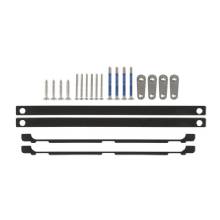
- Bail mount with knobs
- Flush mount kit
- Sun cover
- Trim piece snap covers
- Documentation
Features
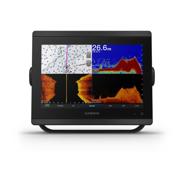
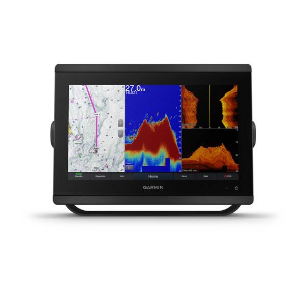
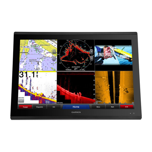
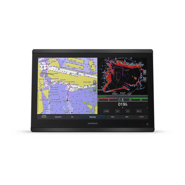
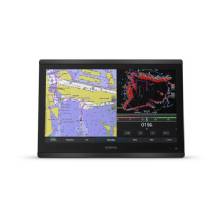
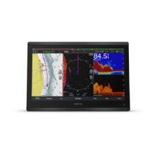
Garmin GPSMAP8612xsv 12" Chartplotter/Sonar Combo with Full HD In-plane Switching (IPS) Touchscreen
Model: 010-02092-03- Features a 12" full HD IPS touchscreen display preloaded with both BlueChart® g3 U.S. coastal and LakeVü HD maps featuring Navionics® data and Auto Guidance technology
- Fully network capable with NMEA 2000® connectivity and the Garmin Marine Network
- Built-in support for the full suite of Garmin sonar capabilities
- Includes Bluetooth® connectivity, ANT® technology and Wi-Fi® networking
- SmartMode station controls enable quick, one-touch access to the information you need
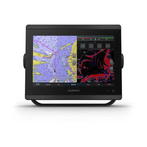
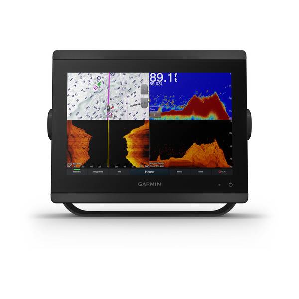
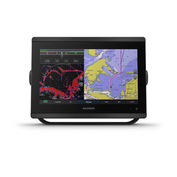
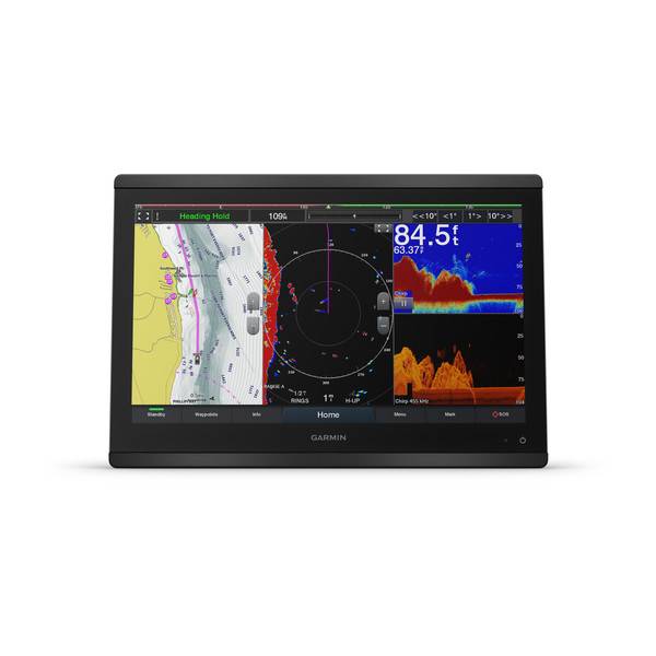
Serious sport fishermen, cruisers, sailors and sail racers demand serious equipment. The easy-to-use, easy-to-install GPSMAP 8612xsv chartplotter/sonar combo delivers MFD performance in a combo-size package. It features a 12" full HD IPS touchscreen display for wider viewing angles, superior clarity and sunlight readability, even with polarized sunglasses. Multiple displays can be flat mounted edge-to-edge to create a sleek glass helm look or can be mounted flush.
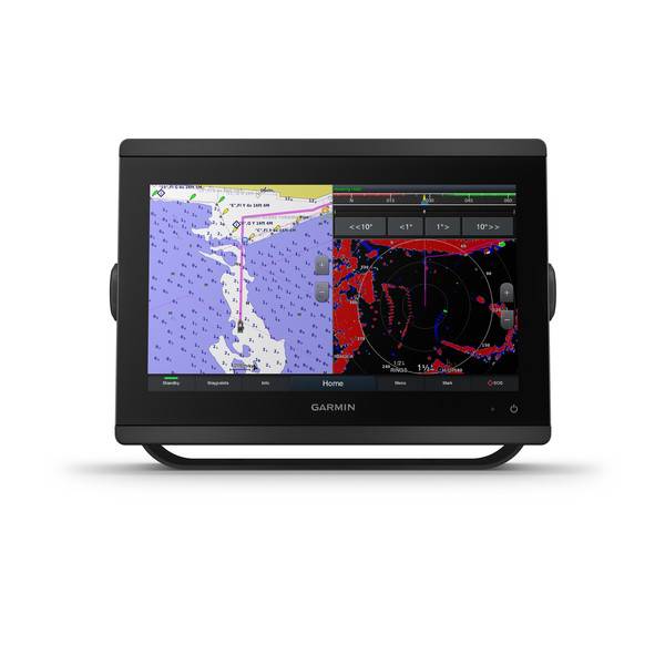
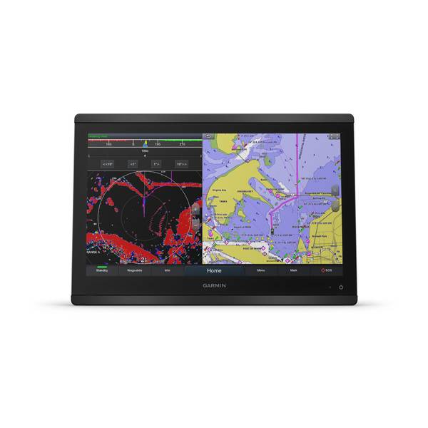
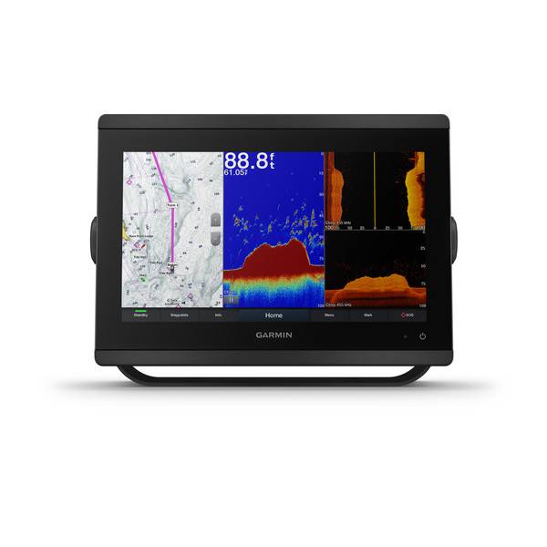
The GPSMAP 8612xsv chartplotter/sonar combo offers built-in support for our industry-leading sonar, including dual-channel 1 kW traditional CHIRP, CHIRP ClearVü and CHIRP SideVü scanning sonars plus built-in support for Ultra High-Definition scanning sonar (no black box required). It also supports the entire Panoptix all-seeing sonar line (transducers sold separately).
For the most detailed, clear and concise charts and maps, this chartplotter is preloaded with BlueChart g3 coastal cartography and LakeVü g3 inland mapping featuring Navionics data. The charts and maps also include our Auto Guidance technology, which shows a suggested route to a destination , based on your boats specifications. The expandable memory allows you to upgrade your maps with accessory map purchases, such as BlueChart® g3 Vision and LakeVü g3 Ultra.
NMEA 2000 networking and the Garmin Marine Network allow you to easily build your full marine electronics suite from radar and autopilots to cameras, instruments and forward-looking sonar controlled from your chartplotter and shared across multiple screens. In addition, our exclusive OneHelm system coordinates many third-party manufactured onboard marine products to bring full control of systems such as digital switching, lighting, stabilization and more conveniently to your chartplotter screen.
The GPSMAP 8612xsv chartplotter has a premium-performance processor that enables fast map drawing, superior networking, video distribution and more. Built-in Wi-Fi technology lets you pair with the free ActiveCaptain® app for access to OneChart, smart notifications , Garmin Quickdraw community data and more. You can also control video streaming from our GC 100 wireless camera and VIRB® action cameras. In addition, built-in ANT wireless technology connects you directly to our quatix® marine watch, gWind Wireless 2 transducer and wireless remote controls.
Networked sonar, radar, cameras, media and digital switching can be independent or incorporated into SmartMode station controls. With SmartMode, everything is designed to give you quick, one-touch access to the information you need to ease high-stress situations such as docking.
The Garmin SailAssist feature provides data, displays and prerace guidance to help you gain a competitive edge. Other sailing features include laylines, enhanced wind rose, heading and course-over-ground lines, true wind data fields and tide/current/time slider. Gauge displays provide need-to-know information at a glance, including true and apparent wind angle, set and drift, true or apparent wind speed, horizontal or vertical graphs and a data bar with customizable fields.
Download the ActiveCaptain app to your smartphone or tablet to manage your marine experience from anywhere from trip planning and prefishing to updating software and purchasing maps.
Specifications
| General | |
| Physical dimensions | 11.9" x 8.5" x 3" (30.3 cm x 21.6 cm x 7.6 cm) |
| Weight | 6.0 lbs. |
| Water rating | IPX6 and IPX7 |
| Display type | touchscreen IPS display (anti-glare finish) |
| Display size | 10.1" x 5.7" (25.7 cm x 14.5 cm) |
| Display resolution | FHD; 1920 x 1200 pixels |
| Power consumption | 3.1 A |
| Antenna | Internal or external over NMEA 2000 |
| Mounting options | Bail, flat or flush (Garmin do not offer any hardware or accessories for a flat-mount installation. Professional tools and knowledge is required.) |
| Receiver | 10 Hz GPS/GLONASS/Galileo |
| Garmin Marine Network ports | 2 |
| Maps & Memory | |
| Accepts data cards | 2 microSD cards (on back) |
| Waypoints | 5,000 |
| Routes | 100 (250 waypoints each) |
| Track log | 50,000 points; 50 saved tracks |
| pre-loaded maps | BlueChart® g3 and LakeVü g3 |
| Outdoor Recreation Features | |
| Tide tables | Yes |
| Chartplotter Features | |
| Garmin Radar compatible | Yes |
| Garmin Sonar compatible | Yes |
| Garmin SmartMode compatible (customizable monitor presets) | Yes |
| Supports AIS (tracks target ships position) | Yes |
| Supports DSC (displays position data from DSC-capable VHF radio) | Yes |
| Supports FUSION-Link compatible radios | Yes |
| GSD Black Box sonar support | Yes |
| GCV Black Box sonar support | Yes |
| ActiveCaptain compatible | Yes |
| Garmin Helm compatible | Yes |
| GRID (Garmin Remote Input Device) compatible | Yes |
| Wireless remote compatible | Yes |
| Sonar Features & Specifications | |
| Dual-frequency (50/200 kHz) sonar capable | Yes |
| Dual-beam (77/200 kHz) sonar capable | Yes |
| Frequencies supported Regular | Traditional: 50/200, 77/200, 83/200 Single Channel CHIRP: 40-250 Dual Channel CHIRP: 40-250 SideVü/ClearVü: CHIRP 260/455/800 (dependent on transducer) |
| Frequencies supported Ultra High Definition | Ultra High-Definition ClearVü: 0.8 MHz (800 kHz), CHIRP range: 760-880 kHz Ultra High-Definition SideVü: 1.2 MHz (1,200 kHz), CHIRP range: 1,060-1,170 kHz (dependent on transducer) |
| Transmit power | 1 kW traditional; 1 kW CHIRP |
| CHIRP sonar technology | Yes (Built-in) |
| ClearVü | Yes |
| SideVü | Yes |
| Maximum depth | 5,000 ft at 1kW (depth capacity is dependent on water bottom type and other water conditions) |
| Connections | |
| NMEA 2000® compatible | Yes |
| Transducer pin numbers | 1 LVS sonar, 1 12 pin scanning sonar, 1- 8 pin sonar |
| NMEA 0183 input ports | 1 differential |
| NMEA 0183 output ports | 1 differential |
| Video input ports | 1 - BNC composite 1 - HDMI (HDCP compliant) |
| Video output ports | 1 HDMI |
| Wireless connectivity | Yes |
Item number: 010-02092-03
UPC: 753759213497
Package weight: 12.60 lb
Other Products in the Series: