GARMIN Gpsmap 8417 Chartplotter


This item is brand new
$7,699.99
Backorder, ships in 3 - 4 weeks
|sw|wi


GPS 17x NMEA 2000 GPS Receiver
GPS 17x GPS Receiver

GPS 19x NMEA 2000 GPS Receiver

GXM 52 - SiriusXM Marine Receiver
Gdl 30A
GDL 40 Weather Receiver
GXM 51 - Weather and Audio XM Receiver
GHP 10 Marine Autopilot System with GHC 20
GHP 10 Marine Autopilot System with GHC 10

GHP 10V Marine Autopilot System with GHC 10
GHP 10V Marine Autopilot System with GHC 20

GHP 12 Sailboat Autopilot System with GHC 10

GHP 20 Marine Autopilot System for Steer-by-Wire with GHC 10

GHP 20 Marine Autopilot System for Viking with GHC 10
GHP 20 Marine Autopilot System for Yamaha Helm Master with GHC 10
GHP 20 Marine Autopilot System with SmartPump and GHC 10

GHP Reactor Hydraulic Autopilot Corepack

GHP Reactor Mechanical Retrofit Solenoid Corepack

GHP Reactor Hydraulic Corepack with SmartPump

GHP Reactor Steer-by-wire Standard Corepack

GHP Reactor Steer-by-wire Corepack for Yamaha Helm Master

GHP Reactor Steer-by-wire Corepack for Viking VIPER

GHP Reactor Steer-by-wire Corepack for Volvo-Penta

GHP Compact Reactor Hydraulic Autopilot Starter Pack


GSD 26 Digital Sonar
GCV 10 SideVu DownVu CHIRP Scanning Sonar

GSD 22 Digital Sonar


Power Cable (Right Angle)


Ais 300
Ais 600
VHF 300 Black
VHF 300 AIS Black
VHF 100 Black
VHF 100i Black
VHF 100 Silver Grey
VHF 100i International
Vhf 110
VHF 200 Black
VHF 200i Black
VHF 200 Silver Gray
VHF 200i International
VHF 210 AIS Marine Radio
VHF 300 Silver Gray
VHF 300i International
VHF 300i Black
VHF 300i AIS Black
VHF 300 AIS Silver Gray
VHF 300i AIS International

Nautix In-view Display


Surface Mount


Flush Mount Kit 8x17


Split Connector 50 ft Right Angle RJ45 Plug


Panoptix PS31 Forward Transducer
Panoptix PS60 Thru-hull Down Transducer
Panoptix PS21 LiveVu Forward Transducer
Panoptix PS21-TM Forward Transom Mount Transducer


NMEA 2000 Transducer Adapter Kit

GNT 10 NMEA 2000 - ANT Transceiver
GMR 18 HD Radar

GMR 604 xHD Open Array and Pedestal

GMR 606 xHD Open Array and Pedestal

GMR 1204 xHD Open Array and Pedestal

GMR 1206 xHD Open Array and Pedestal

GMR 404/406 Radar Pedestal
GMR 404 Open Array Radar
GMR 406 Open Array Radar
GMR 18 Radar

GMR 24 Radar
GMR Fantom 18 Solid-state Radar
GMR Fantom 24 Solid-state Radar
GMR Fantom 4
GMR Fantom 6

GMR 18 HD Plus Radar
GMR 24 HD Radar
GMR 404 xHD Open Array Radar and Pedestal
GMR 406 xHD Open Array Radar and Pedestal

GMR 424 xHD2 Open Array Radar and Pedestal

GMR 624 xHD2 Open Array Radar and Pedestal

GMR 626 xHD2 Open Array Radar and Pedestal

GMR 1224 xHD2 Open Array Radar and Pedestal

GMR 1226 xHD2 Open Array Radar and Pedestal

GBT 10 Bennett Trim Tab Adapter


GC 10 NTSC Marine Camera
GC 10 NTSC Reverse Marine Camera

GWind, GMI 20, DST800 Bundle


GWind, GMI 20, GNX 20, DST800 Bundle

GWind, GMI 20, DST800, GNX 20 Wireless Bundle

9-axis Heading Sensor


GC 12 Marine Camera

GC 10 PAL Marine Camera
GC 10 PAL Reverse Marine Camera
GCL 20 NTSC Low-light Imaging Camera
GCT 20 QVGA 30Hz Thermal Imaging Camera
GCT 30 VGA 9Hz Thermal Imaging Camera
GCL 20 PAL Low-light Imaging Camera
GCT 20 QVGA 9Hz Thermal Imaging Camera
GCT 30 VGA 30Hz Thermal Imaging Camera

Gmi 10


GNX Wind Wired Sail Pack

GNX Wind Wireless Sail Pack

GWS 10 Wind Sensor with GMI 20 Bundle

GWS 10 Wind Sensor with GMI 20 and DST800 Bundle

GWS 10 Wind Sensor with GMI 10 and Smart Triducer Bundle
GWS 10 Wind Sensor
GWS 10 Wind Sensor with GMI 10 Bundle


GWind Wireless Transducer


GWind, GMI 20, DST800 Wireless Bundle


GNX gWind Wireless Pack


Airmar Smart Triducer, Plastic Thru, NMEA 2000

Access, Smart Transducer, P39 Transom, Temp, NMEA 2000


DT800 12 tilt NMEA2000 Smart Transducer Plastic


GRID (Remote Input Device)


Meteor 300 Marine Audio System

Meteor 300 Marine Audio System with Speakers
VIRB Ultra 30


Suggested Maps and Software:
 | Inland Lakes |
 | BlueChart g2, g3 Vision |
 | BlueChart g2, g3 on micro SD card with adapter |
 | Garmin Extras |
 | LakeVu HD Ultra |
 | LakeVu HD |
Contents of the package
- GPSMAP 8417
- Trim piece snap covers
- GPS 19x NMEA 2000 (with pole mount, flush mount and under deck mount adapters)
- Protective cover
- Flush mount hardware
- Power cable
- NMEA 2000 2 m backbone/drop cable
- NMEA 2000 6 m backbone cable
- NMEA 2000 power cable
- NMEA 2000 T-connector & terminator kit
- Documentation
Features
Take Control of a Beautiful HelmPremium 17-inch full HD display with pinch-to-zoom touchscreen control has highest resolution on the marine market
Configure the full system to provide 1-touch setting access for docking, cruising, fishing, anchoring and more
Beautiful glass helm look with ability to install multiple displays either flush or flat mounted edge-to-edge
High-performance processor delivers our fastest map drawing ever and enhanced video processing
Provides a superior user experience across your entire network for radar, sonar and multimedia
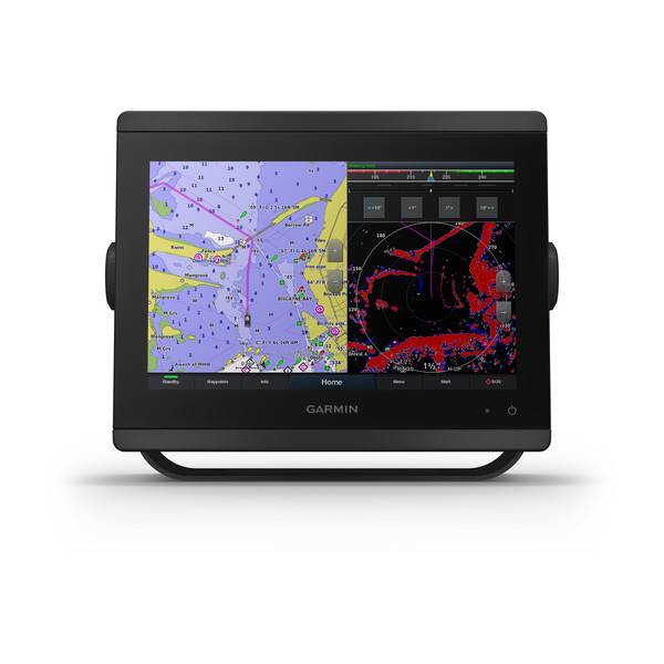
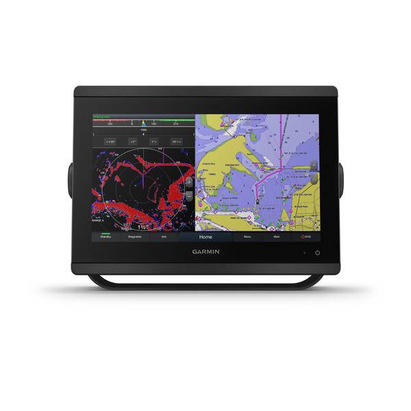
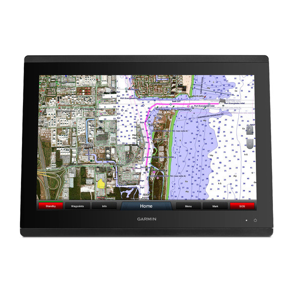
GPSMAP 8417 large-format multifunction display features a 17-inch full HD screen with touch control. Sunlight-readable, anti-glare display is exceptionally easy to view and also includes auto-dimming feature for use in low light or at night. New maximum glass design enables you to experience a beautifully powerful, completely networked helm at your fingertips. In-plane switching (IPS) LCD display an industry first for this class provides consistent, accurate colors from all viewing angles. It also provides standard USB touch output for use as a touchscreen monitor for Windows® and Mac® operating systems. Install multiple displays with the industrys lowest flush-mount profile or flat mount them edge-to-edge to create a sleek glass helm look. Quick, 1-touch access to the information you need makes boating easier.
Full System Integration
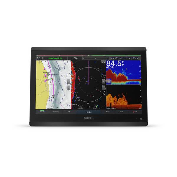
GPSMAP 8417 integrates various sonar technologies as well as autopilot, connectivity, apps, engine data and multi-media. User data can be automatically synced for all networked networked 8400/8600 series chartplotters across multiple helms everything you need is at your fingertips, all on 1 screen. A full digital switching system uses CZone technology. You can power up your boat while away from the dock, switch on pumps and control lights even underwater lights. Nearly all of your controls are available right at your fingertips either at the helm or programmed into a remote key fob or an app on your tablet provided by CZone by Mastervolt.
New High-performance Processor
Experience the fluidity of our fastest map drawing ever and enhanced video processing. Add up to 4 IP camera streams and simultaneous Garmin Helm support. In addition, all your added sensors, such as radar, sonar, multimedia and more, will benefit from the increased performance to provide a premium experience across your boats entire network.
Customize Layouts with SmartMode Control
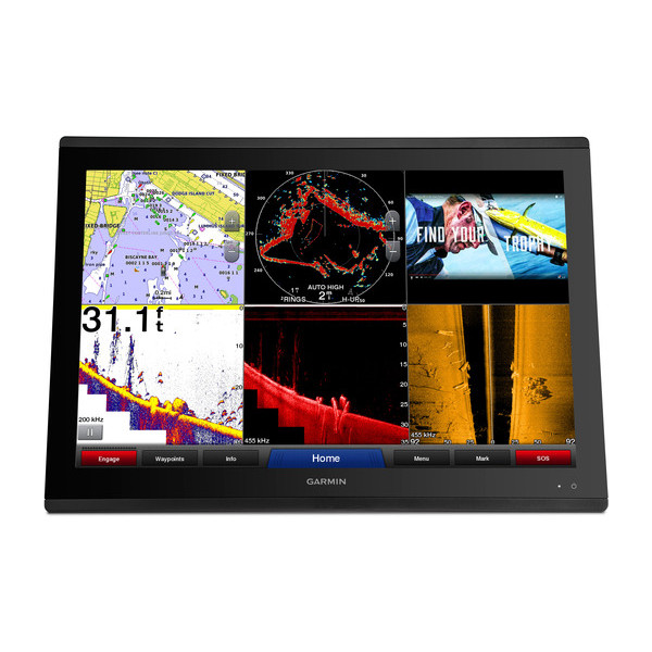
To make boating easier, GPSMAP 8417 includes presets for sonar, radar, cameras, media and digital switching, which can be independent or incorporated into SmartMode. With SmartMode control, you can quickly change all screens at a helm in sync to a preset mode, for example, fishing, docking, night cruising, etc. One-touch access allows you to switch all monitors in sync from 1 mode to another without manually switching each monitor separately. Fully customizable layouts, data and gauges allow you to place the information you need to see right where you want it.
Garmin Marine Network and NMEA 2000® Network Support
Full-network compatibility allows you to add more to your boat. GPSMAP 8417 supports radar, autopilot, instruments, multiple screens, FUSION-Link entertainment system, sensors, remote sonar modules, digital switching, weather, thermal cameras, GRID remote device and more. Its also FLIR camera compatible and provides SiriusXM support.
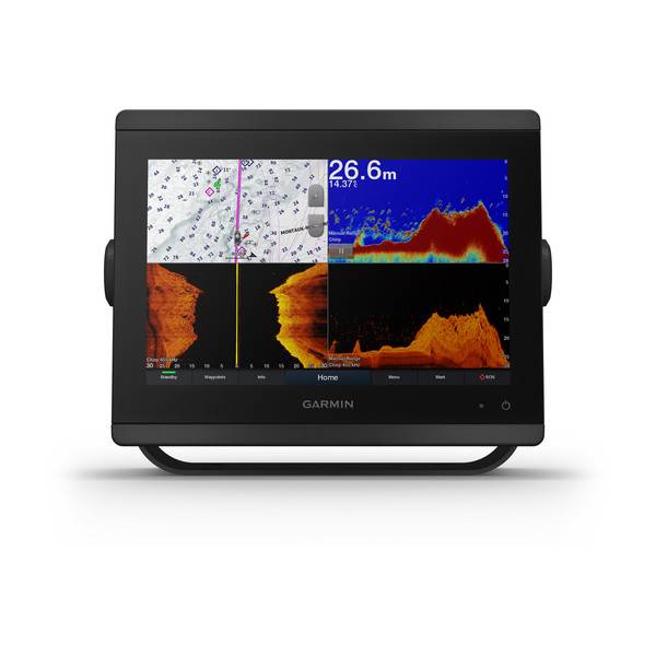
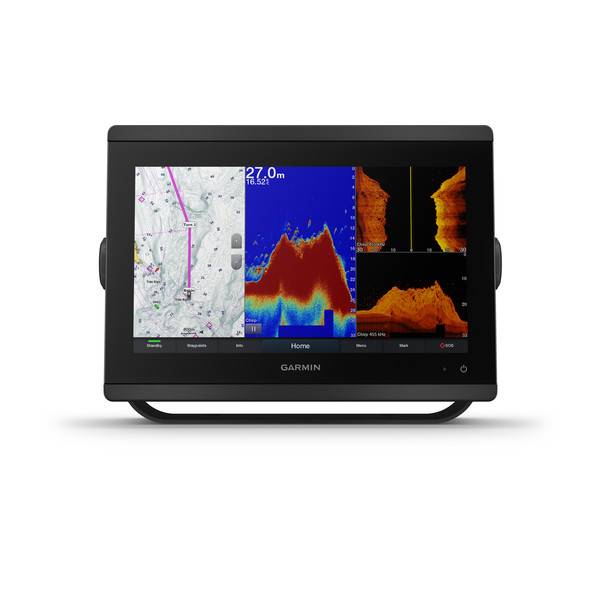
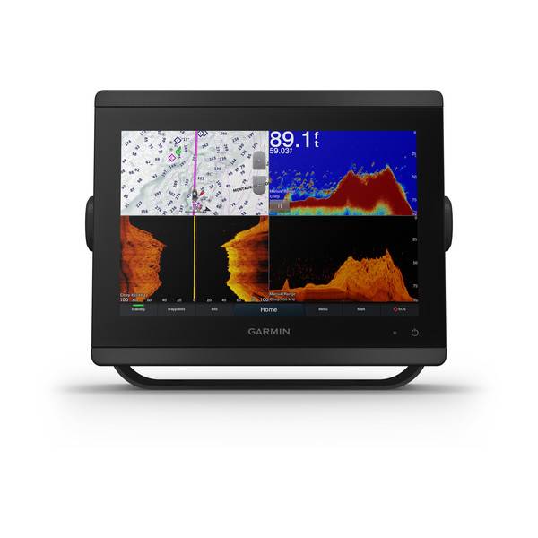
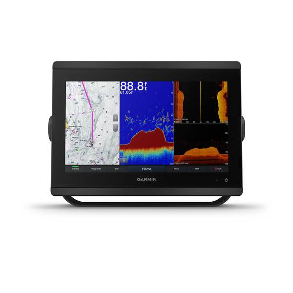
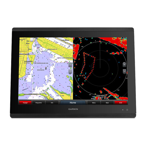
View Multiple Sonar Sources Simultaneously
GSD 26 CHIRP professional sonar, GSD 24 advanced sonar, and GCV 10 or GSD 25 DownVü and SideVü scanning sonar, even Garmin Panoptix all-seeing sonar, can exist on the same system. You can view various sonars together on 1 monitor or across multiple monitors in multi-display systems.
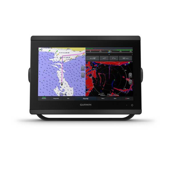
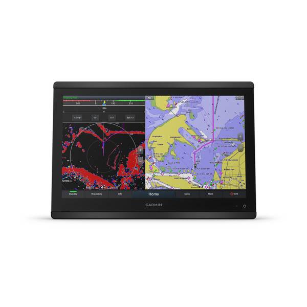
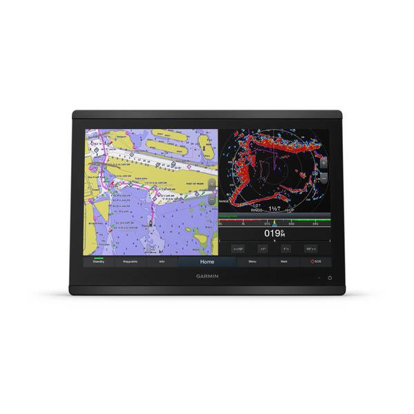
Add Array or Dome Radar
You can add your choice of Garmin marine radar, including our powerful xHD2 open-array radars, GMR Fantom open-array radars with MotionScope technology or xHD dome radars that pair ease of use with advanced open-array features.
Network Sharing
GPSMAP 8417 allows you to share features with other compatible GPSMAP units such as radar, supplemental maps and user data, including waypoints, routes and tracks. You can also share images from Garmin VIRB® action cameras, GC 10 marine cameras and FLIR cameras. User data entered into 1 chartplotter can be automatically synced with other chartplotters in a network.
Heading, Position Refreshed 10 Times per Second
Fast, responsive built-in 10 Hz GPS refreshes your position and heading 10 times each second to make your movement on the screen more fluid. Now, its quick and easy to drop up to 5,000 accurate waypoints and find your way back to them.
SailAssist Features
Supported sailing features include laylines, enhanced wind rose, heading and course-over-ground lines, true wind data fields and tide/current/time slider. Racing features include pre-race guidance, synchronized race timer, virtual starting line, time to burn and layline data fields. Gauge displays are designed to provide important, need-to-know information at a glance, including true and apparent wind angle, set and drift, true or apparent wind speed, horizontal or vertical graphs and a data bar with customizable data fields.
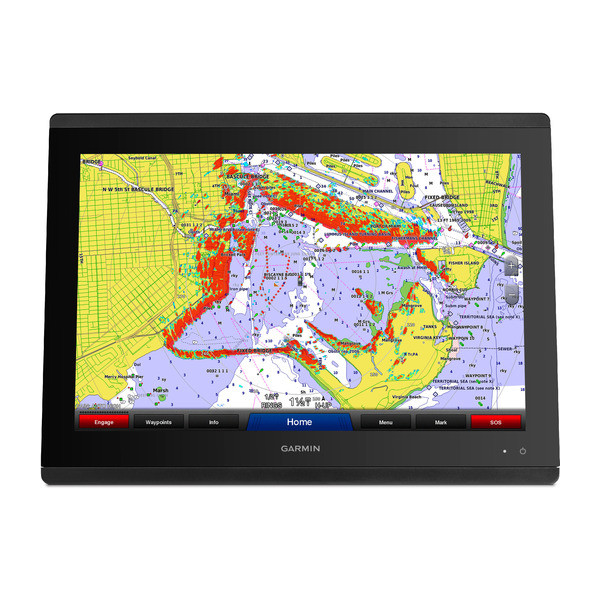
Create Your Own HD Maps
Quickdraw Contours is a free, easy-to-use software feature that is already installed on your GPSMAP 8417. It instantly creates your very own personalized HD fishing maps with 1-foot contours. Tailor them to fit your needs. They are your maps. You own them. Keep the data to yourself or share it with Garmin or your friends. Theres no special surveying expertise required. You just fish while it creates maps. You dont have to wait around or send your files away like other mapping software requires your results appear instantly. Use with any Garmin Panoptix, any HD-ID, any CHIRP-enabled, Garmin DownVü transducer or NMEA 2000-compatible depth transducer. Have more than 1 sonar device installed onboard? Quickdraw Contours automatically selects the most capable sonar device to provide the very best results for you!
Upgrade to Our Best Maps on the Water
Add a Garmin Card Reader that provides convenient remote mounting and a single access point for 2 SD card slots for accessory map purchases such as LakeVü HD Ultra with MaxDef Lakes, BlueChart g2 HD or BlueChart® g2 Vision® HD, which add Garmin-patented Auto Guidance 3.0 and other great features. You can add multiple card readers for additional access points. Waterproof magnetic door allows card reader to be mounted horizontally or vertically (sold separately).
FUSION-Link Entertainment System
Enjoy the ability to control all compatible FUSION-Link-enabled audio systems directly from your compatible chartplotter display.
Built-in Connectivity
Its easy to connect to peripheral devices with built-in Wi-Fi® connectivity, ANT® technology, 4 wired Ethernet ports, NMEA 2000, HDMI and USB ports with complete network compatibility. Its easier than ever to enjoy the full range of features provided by Garmin Helm and BlueChart® Mobile apps.
View, Control Your Device from a Smartphone or Tablet
Garmin Helm allows you to view and control your compatible chartplotter from a compatible smartphone or tablet while providing enhanced situational awareness for the mariner. Easily switch between portrait and landscape modes to accommodate mounting preferences. When using an iPhone® or iPad®, you can even record a movie of your chartplotter screen to share with friends and family.
Get Onboard with BlueChart Mobile
With BlueChart Mobile 2.0, a free app downloaded from the App Store, you can get reliable weather information while you plan marine routes on your iPad or iPhone then wirelessly transfer them to your boats compatible networked Garmin chartplotter. Continue to acquire current weather information from your cellular-based Apple® device, and stream that data onto your chartplotter screen. Even if you dont have a Garmin chartplotter, you can still take advantage of the tremendous features of BlueChart Mobile on your compatible Apple device.
Multiple Depth Range Shading
Designate up to 10 different depth ranges each with its own color. Makes it easier to view target depths at a glance.
Commission Autopilot from Chartplotter
To make commissioning easier and more convenient, you can handle the entire autopilot commissioning process from your chartplotter screen.
Specifications
Physical & Performance | |
| Physical dimensions | 16.5" x 12.1" x 2.8" (41.9 cm x 30.7 cm x 7.1 cm) |
| Display size, WxH | 14.4" x 9.1" (36.6 x 23.1 cm) |
| Display resolution, WxH | 1920 x 1200 pixels |
| Display type | Touchscreen IPS display (anti-glare finish) |
| Weight | 11.48 lbs (5.21 kg) |
| Water rating | IPX7 |
| Antenna | External only |
| NMEA 2000® compatible | |
| NMEA 0183 compatible | |
| SiriusXM Weather & Radio compatible | |
| Power consumption | Max power usage at 10 Vdc: 40 W Typical current draw at 12 Vdc: 2.8 A Max current draw at 12 Vdc: 3.5 A |
| Mounting options | Flush or Flat |
| Garmin Marine Network ports | 4 |
Maps & Memory | |
| Preloaded maps | None |
| Accepts data cards | 2 SD Cards (with Garmin SD card reader accesory) |
| Waypoints | 5,000 |
| Routes | 100 (250 waypoints each) |
| Track log | 50,000 points; 50 saved tracks, with 5000 points each |
Chartplotter Features | |
| Garmin Radar compatible | |
| Garmin Sonar compatible | Yes |
| Garmin SmartMode compatible (customizable monitor presets) | |
| Supports AIS (tracks target ships position) | |
| Supports DSC (displays position data from DSC-capable VHF radio) | |
| Tide tables | |
| Supports Fusion-Link compatible marine radios | |
| GSD Black Box sonar support | |
| GCV Black Box sonar support | |
| BlueChart® Mobile (planning) compatible | Yes |
| Garmin Helm compatible | Yes |
| GRID (Garmin Remote Input Device) compatible | |
Sonar Features & Specifications | |
| Dual-frequency (50/200 kHz) sonar capable | Yes (with compatible black box sonar) |
| Dual-beam (77/200 kHz) sonar capable | Yes (with compatible black box sonar) |
| CHIRP sonar technology | Yes (with external black box) |
| DownVü | Yes (with GCV black box, sold separately) |
| SideVü | Yes (with GCV black box, sold separately) |
Connections | |
| NMEA 0183 input ports | 4 |
| NMEA 0183 output ports | 2 |
| Video input ports | 1 - BNC composite 1 - HDMI (HDCP compliant) |
| Video output ports | 1 - HDMI |
| Wireless connectivity | Yes |
Additional | |
| Additional | Additional connections:
HDMI and composite video inputs are encoded and shared across the Garmin Marine Network to other comaptible chartplotters. |
Series Comparison
| GPSMAP | 8000/8200 | 8400/8600 |
| Full HD widescreen display | | |
| Sunlight readable multi-touch display | | |
| Display type/resolution (pixels) | GPSMAP 8015/8215, XGA - 1024 x 768 GMM 170, SXGA - 1280 x 1024 GMM 190, SXGA - 1280 x 1024 | GPSMAP 8417/8617, WUXGA - 1920 x 1200 GPSMAP 8422/8622, FHD - 1920 x 1080 GPSMAP 8424/8624, WUXGA - 1920 x 1200 |
| Preloaded maps | 8000: Worldwide Basemap 8200: U.S. BlueChart g2 | 8400: Worldwide Basemap 8600: U.S., Canada and Bahamas BlueChart g2 & U.S. LakeVü HD |
| J1939 support | | |
| Accepts data cards - For optional mapping and user data storage | Requires Garmin Card | Reader Requires Garmin Card Reader (sold separately) |
| Panoptix support | | |
| Network chart sharing | | |
| Garmin radar compatible - Control radar via GPSMAP display | | |
| Garmin autopilot compatible - Control autopilot via GPSMAP display | | |
| Sounder support - GSD 24, 25, 26 and GCV 10 | | |
| Garmin SmartMode controls | | |
| FUSION-Link support - Control audio via GPSMAP display | | |
| SiriusXM weather & radio compatible | | |
| Camera support - FLIR thermal cameras - Axis IP cameras | | |
| Apps - BlueChart Mobile and Garmin Helm | | |
| Wireless connectivity | Wi-Fi (Wi-Fi adapter kit required, sold separately) | Built-in Wi-Fi and ANT |
| NMEA 2000 | | |
| NMEA 0183 | 4 input 2 output | 4 input 2 output |
| Garmin Marine Network | 4 ports | 4 ports |
| Video inputs | 4 BNC composite 1 BNC component 1 DVI-I | 1 BNC composite 1 HDMI (HDCP compliant) Both video sources are shared across the network |
| Video outputs | 1 DVI-I | 1 HDMI |
| Video sharing via marine network | View only | View and share |
| Mounting options | Flat or Flush | Flat or Flush |
Item number: 010-01510-00
UPC: 753759143121
Package weight: 21 lb
Other Products in the Series: